
Displaying items by tag: Earth observation
SpaceTech GmbH

SpaceTech undertakes a wide spectrum of space activities in the field of scientific and Earth observation missions.
The scope of activities covers design and engineering work on mission and satellite system level, the development and production of space equipments such as solar generators, high precision mechanisms, attitude sensors and the launch services support. The company is also active in terrestrial applications and provides project management support to the implementation of Tsunami Warning Systems and delivers land and ocean based sensor stations.
European Association of Remote Sensing Companies (EARSC)

The European Association of Remote Sensing Companies (EARSC) is a non-profit-making organisation which is actively involved in coordinating and strengthening the Earth-observation (EO) chain and promoting the European geo-information industry.
EARSC is open to corporative and observer members with deeply interest in providing services delivering information based on observations of the Earth and its environment.
Since 1989, EARSC has provided its Members technical expertise and policy guidance. The Association maintains close links with key European Institutions, including Industry, ESA and National Space Agencies, providing a key unified voice on wider European issues.
Institute for Global Environmental Strategies (IGES)

The Institute for Global Environmental Strategies (IGES) is an American organisation dedicated to Earth & space science education. It is fostering national & international cooperation in global Earth observations.
RazakSAT
RazakSAT is a Malaysian satellite carrying a high-resolution camera.
It was launched into low Earth orbit by a Falcon 1 rocket on July 14, 2009. It was placed into a near-equatorial orbit that presents many imaging opportunities for the equatorial region. It weighs over three times a much as TiungSAT-1 and carries a high resolution Earth observation camera. Developed in conjunction with Satrec Initiative, the satellite's low inclination orbit (9 degrees) brought it over Malaysia a dozen or more times per day. This was intended to provide greatly increased coverage of Malaysia, compared to most other Earth observation satellites.
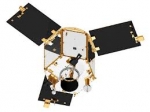
Pleiades (satellite)
The Pléiades constellation is composed of two very-high-resolution optical Earth-imaging satellites. Pléiades 1 and Pléiades 2 will provide coverage of Earth’s surface with a repeat cycle of 26 days . Designed as a dual civil/military system, Pléiades will meet the space imagery requirements of European defence as well as civil and commercial needs.
The Pléiades system was designed under the French-Italian ORFEO program (Optical & Radar Federated Earth Observation) between 2001 and 2003.
The Pléiades programme was launched in October 2003 with CNES (the French space agency) as the overall system prime contractor and EADS Astrium as the prime contractor for the space segment. Pléiades-1 was launched via a Russian Soyuz ST rocket out of French Guiana on December 16, 2011. Pléiades 2 will launch in December 2012.
Spot Image is the official and exclusive worldwide distributor of Pléiades products.
TOPEX/Poseidon satellite
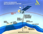
Launched on August 10, 1992, TOPEX/Poseidon was a joint satellite mission between NASA, the U.S. space agency, and CNES, the French space agency, to map ocean surface topography. The first major oceanographic research vessel to sail into space, TOPEX/Poseidon helped revolutionize oceanography by proving the value of satellite ocean observations.
The satellite operations ended on January 2006.
Jason-1 was launched in 2001 to continue the on-going measurements of sea surface topography.
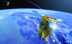
Swarm (spacecraft)
Swarm is a European Space Agency (ESA) mission to study the Earth's magnetic field.
The Swarm concept consists of a constellation of three satellites in three different polar orbits between 450 and 550 km altitude.
The launch is currently planned for mid-November 2013; in 2010, ESA awarded the contract to Eurockot.
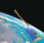
TerraSAR-X
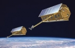
TerraSAR-X, a German Earth observation satellite, is a joint venture being carried out under a public-private-partnership between the German Aerospace Center (DLR) and EADS Astrium; the exclusive commercial exploitation rights are held by the geo-information service provider Infoterra. TerraSAR-X was launched on June 15, 2007 and has been in operational service since January 2008. Following the launch of a second sister satellite, TanDEM-X in early 2010, the two satellites act as a pair.
IceBridge
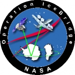
IceBridge, a six-year NASA mission, is the largest airborne survey of Earth's polar ice ever flown. It will yield an unprecedented three-dimensional view of Arctic and Antarctic ice sheets, ice shelves and sea ice. These flights will provide a yearly, multi-instrument look at the behavior of the rapidly changing features of the Greenland and Antarctic ice.
Data collected during IceBridge will help scientists bridge the gap in polar observations between NASA's Ice, Cloud and Land Elevation Satellite (ICESat) -- in orbit since 2003 -- and ICESat-2, planned for early 2016. ICESat stopped collecting science data in 2009, making IceBridge critical for ensuring a continuous series of observations.
IceBridge will use airborne instruments to map Arctic and Antarctic areas once a year. IceBridge flights are conducted in March-May over Greenland and in October-November over Antarctica. Other smaller airborne surveys around the world are also part of the IceBridge campaign.
ICESat-2
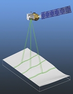
ICESat-2 (Ice, Cloud, and land Elevation Satellite 2), part of NASA's Earth Observing System, is a planned (year of writting: 2012) satellitemission for measuring ice sheet mass elevation, sea ice freeboard as well as land topography and vegetation characteristics. ICESat-2 is a planned follow-on to the ICESat mission. It will be launched in 2016 from Vandenberg Air Force Base in California into a near-circular, near-polar orbit with an altitude of approximately 496 km. It is being designed to operate for 3 years, and will carry enough propellant for 7 years.
The ICESat-2 mission is designed to provide elevation data needed to determine ice sheet mass balance as well as vegetation coverage information. It provides topography and vegetation data around the globe, in addition to the polar-specific coverage over the polar regions.
The ICESat-2 project is being managed by NASA Goddard Space Flight Center. The sole instrument is being designed and built by NASA Goddard Space Flight Center, and the bus is being provided by Orbital Sciences Corporation.