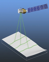
ICESat-2 (Ice, Cloud, and land Elevation Satellite 2), part of NASA's Earth Observing System, is a planned (year of writting: 2012) satellitemission for measuring ice sheet mass elevation, sea ice freeboard as well as land topography and vegetation characteristics. ICESat-2 is a planned follow-on to the ICESat mission. It will be launched in 2016 from Vandenberg Air Force Base in California into a near-circular, near-polar orbit with an altitude of approximately 496 km. It is being designed to operate for 3 years, and will carry enough propellant for 7 years.
The ICESat-2 mission is designed to provide elevation data needed to determine ice sheet mass balance as well as vegetation coverage information. It provides topography and vegetation data around the globe, in addition to the polar-specific coverage over the polar regions.
The ICESat-2 project is being managed by NASA Goddard Space Flight Center. The sole instrument is being designed and built by NASA Goddard Space Flight Center, and the bus is being provided by Orbital Sciences Corporation.


