Galileo is a joint initiative of the European Commission (EC) and the European Space Agency (ESA). Galileo will be Europe’s own global navigation satellite system, providing a highly accurate, guaranteed global positioning service under civilian control. It will be inter-operable with GPS and GLONASS, the two other GNSS (Global Navigation Satellite Systems). The complete system consists of:
• A space segment of 30 MEO satellites in 3 planes inclined at 56º
• A launch segment to place the satellites into their operational orbits
• A control ground segment for monitoring and control of the satellites
• A mission ground segment managing all mission specific data
• A user ground segment of equipment capable of receiving and using Galileo signals

Figure 1: The Galileo constellation of 30 spacecraft (image credit: ESA)
The Galileo program has been structured into two phases:
1) IOV (In-Orbit Validation) phase: IOV consists of tests and the operation of four satellites and their related ground infrastructure. The first two IOV satellites were launched on Oct. 21, 2011. The second pair of IOV satellites, IOV-3 and IOV-4, were launched on Oct. 12, 2012.
2) FOC (Full Operational Capability) phase: FOC consists of the deployment of the remaining ground and space infrastructure. It includes an initial operational capability phase of 18 operational satellites. The full system will consist of 30 satellites, control centers located in Europe and a network of sensor stations and uplink stations installed around the globe.
|
On July 1, 2008, the EC and ESA launched the procurement process of Galileo. Political decisions made by the European Parliament and the Council in 2007 resulted in the allocation of a budget for the European satellite navigation programs EGNOS and Galileo and provided for an agreement on the governance structure of the programs. This framework provides for the deployment of the FOC (Full Operational Capability) of Galileo under a public procurement scheme, entirely financed out of the European Community budget. The European Commission (EC) acts as program manager and contracting authority, and ESA acts as its procurement and design agent. The procurement initiated includes six WPs (Work Packages). In this setup, ESA functions in its role as the designated procurement agent on behalf of the European Union: 1) • WP1 deals with system support services. • WP2 is dedicated for the ground mission. • WP3 covers the ground control. • WP4 covers the development of the spacecraft. • WP5 deals with the launch services of the constellation. • WP6 is dedicated to the preparation activities as well as all the operations services of the fully-deployed Galileo system. - WP6 Work Order 1 covers all activities related to the completion of the IOV (Galileo In Orbit Validation) activities – the first four Galileo satellites are due for launch in 2011. - WP6 Work Order 2 is dedicated to the implementation and activities of an integrated engineering team supporting ESA for system operations. - WP6 Work Order 3 deals with the completion of deployment of operations for Galileo’s FOC, scheduled for 2014. - WP6 Work Order 4 covers the full deployment of the two Galileo Ground Control Centers, in Germany at Oberpfaffenhofen and in Italy at Fucino. |
Table 1: Overview of the Galileo program Work Packages 1) 2) 3)
Contract kick-off with OHB as the prime of the FOC space segment WP1 (Work Package 1) took place in late January 2010; two years later, again after highly competitive bidding and based on the performance in WP1, OHB was also able win the space segment Work Order 2 contract, thus increasing the total number of satellites to be built to 22. The Galileo FOC project is characterized by an extremely challenging schedule, which foresees a delivery of a finalized satellite every six weeks. 4)
Development of the Galileo Satellites
For the Galileo FOC development phase, OHB System of Bremen, Germany teamed with SSTL (Surrey Satellite Technology Ltd.), UK. Within this team, OHB-System is the prime contractor and is responsible for the development of the 22 spacecraft. SSTL is fully responsible for the satellite payloads. The system level activities will be led by OHB-System, making use of the experience gained by SSTL through its GIOVE-A activities. 5)
ESA is already procuring 4 satellites from Astrium through its IOV (In-Orbit Validation) program which brings the number of operational Galileo satellites now under contract to 18.

Figure 2: Illustration of the Galileo FOC spacecraft (image credit: OHB System)
Spacecraft of the FOC series:
The production of the spacecraft series, with a delivery schedule of each pair of satellites in periods of 3 months, requires an assembly line production technique to meet the time table. This can only be achieved by implementing a modular satellite design.
The FOC satellites, 22 in total, provide the same operational services as their predecessors, but they are built by a new industrial team: OHB in Bremen, Germany build the satellites with Surrey Satellite Technology Ltd in Guildford, UK contributing the navigation payloads.

Figure 3: Galileo FOC solar wing deployment being checked at ESA/ESTEC (image credit: ESA)
Legend to Figure 3: The navigation satellite’s pair of 1 m x 5 m solar wings, carrying more than 2500 state-of-the-art gallium arsenide solar cells, will power the satellite during its 12 year working life. 6)
The design of the 22 Galileo FOC satellites is quite different with respect to that of their four Galileo IOV (In-orbit Verification) counterparts. For technical and cost reasons, only half of the units aboard were re-used from IOV. Part of the rationale are also more demanding requirements for FOC compared with IOV, e.g. an increased RF signal output power level, tougher radiation requirements, and harsher launch load requirements to name a few. Hence, qualification on subsystem and system level had to be done from scratch (Ref. 4).
Fulfilment of ESA's FOC satellite requirements was achieved through a simple and robust design, leading to a satellite of ~720 kg with a provided power production of 1.9 kW (end of life), which provides navigation signals in L1, E5, and E6 bands, as well as Search-and-Rescue services. The FOC satellite design is depicted in Figure 4.

Figure 4: Galileo FOC satellite design with “plug-in” propulsion module (image credit: OHB System)
A lot of OHB's development work went into optimizing the design for series production. It was identified that in order to meet the production cadence requirement of six weeks, parallelization of work on each satellite would have to be achieved. As this is very hard to achieve at late stages of integration and testing of a satellite, the focus was put in particular on the early stages of MAIT (Manufacturing, Assembly, Integration, and Testing).
The satellites are integrated in seven modules, depicted also in Figure 5:
• the propulsion module (integrated at the propulsion supplier, Moog Inc.)
• the solar generator module (integrated at the solar generator supplier)
• clock, antenna, and payload core module (integrated at SSTL, OHB's co-prime, responsible for the payload, located in Guildford, UK)
• the center and the platform core modules (integrated at OHB's premises in Bremen, Germany).
Work on these seven modules can be executed independently from each other and in parallel to each other. A good example for that is the propulsion module. While in most satellites, the propulsion system is distributed over the entire spacecraft, the modularity intended for Galileo FOC let OHB designers to mount all the propulsion-related systems on one panel, which can be integrated and replaced also late in the MAIT process (as depicted in Figure 4). The big access panel in the launch dispenser-facing side of the satellite increases the ease of access into the satellite, also at late stages of the assembly.
In the next step of integration after module integration, the seven modules form the platform and the payload (see Figure 2), which also can be treated independently from each other and in parallel to each other (payload at SSTL, platform at OHB). Final integration of payload and platform and system level tests are then also carried out at OHB. Subsequently, the integrated and tested satellites are shipped to ETS (European Test Services) in Noordwijk, The Netherlands, for the environmental test campaigns.
Development work was based on early availability of functional models of the board computers. These were used in subsystem breadboards to facilitate software development with hardware in the loop as early on as possible. Further development work was carried out in two thermal development models that focussed on the two thermally critical areas: firstly, the clock panel, where clock temperature stability was demonstrated, and secondly the area of the travelling wave tubes, where sufficient high dissipation on limited radiator area was validated.
On system level, a flat-sat engineering model was employed to check out inter-subsystem compatibility and interaction. A further payload-only engineering model was employed by SSTL at their premises for payload-level development work.

Figure 5: Illustration of satellite modules (image credit: OHB System)
MAIT (Manufacturing, Assembly, Integration, and Testing): The MAIT approach picks up on the design of the satellite and focuses on the series production and the production cadence as well. The production is based on an island mode, while the check-out equipment and ground support equipment stays in place, it is the satellites that move from station to station. The activities that are executed at a given station are trimmed to give all stations more or less the same stay duration. After that duration, all satellites move forward one station. Primary goal is to keep the flow of satellites going, meaning to avoid “clogging” the production pipeline, as this would have impact on all previous islands, which cannot turn to the next satellite in line, whereas all succeeding islands or stations would “run dry”. Hence margin for trouble shouting must be taken into account. For larger issues in the production pipeline, there is a so-called “recovery island” foreseen, which is equipped with all types of ground support equipment which can handle problems that take several days or even weeks to resolve while the rest of the pipeline continues normally.
|
Spacecraft launch mass |
730 kg (including 63 kg of fuel and 30 kg margin) |
|
Spacecraft body size, span |
2.5 m x 1.2 m x 1.1 m |
|
Spacecraft span |
14.67 m |
|
Overall size at launch |
2.91 m 1.70 mx 1.40 m |
|
Spacecraft design life |
≥12 years in space, ≥ 5 years ground storage |
|
Orbit |
MEO, r=29800 km, inclination = 56º, 3 orbital planes with RAAN spacing of 120º, at EOL transfer to graveyard orbit |
|
Clock frequency stability |
PHM (Passive Hydrogen Maser):<4.5 x 10⁻¹⁴ at 30000 s |
|
Navigation signal |
3 bands (E5, E6, L1) |
|
Design approach |
Satellite consists of 7 modules, resulting in simple interfaces, enabling parallelized MAIT (Manufacturing, Assembly, Integration and Testing) |
|
Satellite reliability |
0.811/12 years (w/o SAR PL) |
|
Failure tolerance |
- Full performance maintained after single failure |
|
Processor |
TEMIC TSC695 32-bit RISC processor (radiation hardened) |
|
Satellite radiation hardness |
MEO compliant |
|
Up- / Downlink |
|
|
Common Security Unit |
Combines functions for payload and platform |
|
Power |
|
|
Structure |
Aluminum sandwich panel design featuring 3 tillable panels and access panels allow late and easy access |
|
AOCS |
3-axis stabilized |
|
Propulsion |
Slanted N2H4 monopropellant thrusters (2 x 4 nozzles with 1 N thrust each, fully redundant), blowdown pressurization |
Table 2: Key parameters of the Galileo spacecraft 7)

Figure 6: The main antenna of the FM2 satellite is being inspected at ESTEC prior to mass property testing in August 2013 (image credit: ESA, Anneke Le Floc'h) 8)
Nominal orbit of the Galileo constellation: The Galileo constellation is composed of a total of 30 MEO (Medium Earth Orbit) satellites, of which 6 are spares (Figure 1). Each satellite will broadcast precise time signals, ephemeris and other data. The Galileo satellite constellation has been optimized to the following nominal constellation specifications:
- Circular orbits (satellite altitude of 23,222 km), orbital inclination of 56°, three equally spaced orbital planes.
- Eight operational satellites, equally spaced in each plane, two spare satellite (also transmitting) in each plane.
Launch: On August 22, 2014, the first two Galileo FOC satellites,FOC-1 (FM1) and FOC-2 (FM2), were launched from Kourou on the Soyuz ST-B vehicle (flight VS09), operated by Arianespace. 9)
Unfortunately, the orbit injection of the FOC spacecraft didn't occur as planned and the satellites did not reach their intended orbital position.
The liftoff and first part of the mission proceeded nominally, leading to the release of the satellites according to the planned timetable, and reception of signals from the satellites. It was only a certain time after the separation of the satellites that the ongoing analysis of the data provided by the telemetry stations, operated by ESA and the French space agency, CNES, showed that the satellites were not in the expected orbit.
The targeted orbit was circular, inclined at 56º with a semi major axis of 29,900 km. The satellites are now in an elliptical orbit, with an eccentricity of 0.23, a semi major axis of 26,200 km and inclined at 49.8º.
According to the initial analyses, an anomaly is thought to have occurred during the flight phase involving the Fregat upper stage, causing the satellites to be injected into a noncompliant orbit.

Figure 7: Photo of the Galileo FOC-3 and FOC-4 satellites fitted onto dispenser (image credit: ESA/CNES/ARIANESPACE-Service Optique CSG) 10)

Figure 8: Illustration of satellite configurations in various mission phases (image credit: OHB System)
Launch: The seventh and eighth Galileo satellites (FOC-3 and FOC-4) were successfully launched together on March 27, 2015 (21:46:18 UTC) atop a Soyuz-STB/Fregat vehicle (VS11) from Europe's Spaceport (Kourou, ELS) in French Guiana. 11) 12)
All the Soyuz stages performed as planned, with the Fregat upper stage releasing the satellites into their target orbit close to 23, 500 km altitude, around 3 hours 48 minutes after liftoff. Shortly thereafter, the two satellites sent their first signals from orbit, which were received by the CNES control center in Toulouse. 13)
Following initial checks, run jointly by ESA and France’s CNES space agency from the CNES Toulouse center, the two satellites will be handed over to the Galileo Control Center in Oberpfaffenhofen, Germany and the Galileo in-orbit testing facility in Redu, Belgium for testing before they are commissioned for operational service. This is expected in mid-year.

Figure 9: Artist's view of the protective launcher fairing which jettisoned at 3 min 29 sec after launch, revealing the two Galileo satellites attached to their dispenser atop the Fregat upper stage (image credit: Arianespace, ESA)
Launch: The Galileo-9 and -10 satellites (FOC-5 and FOC-6) were launched atop a Soyuz rocket at 02:08 GMT on September 11, 2015 from Kourou, Europe’s Spaceport in French Guiana. 14) 15) 16)
All the Soyuz stages performed as planned, with the Fregat upper stage releasing the satellites into their target orbit close to 23,500 km altitude, around 3 hours and 48 minutes after liftoff. Shortly thereafter, they sent their first “sign of life” to ESOC (European Space Operation Center) in Darmstadt, Germany. Over the next few days, the two satellites will also be undergoing preliminary function testing.
Two further Galileo satellites are still scheduled for launch by end of 2015. These satellites have completed testing at ESA/ESTEC in Noordwijk, the Netherlands, with the next two satellites also undergoing their own test campaigns.
Next year the deployment of the Galileo system will be boosted by the entry into operation of a specially customized Ariane 5 launcher that can double, from two to four, the number of satellites that can be inserted into orbit with a single launch.
Launch: The Galileo-11 and -12 satellites (FOC-7 and FOC-8) were launched atop a Soyuz STB/Fregat rocket at 11:51:56 GMT on December 17, 2015 from Kourou, Europe’s Spaceport in French Guiana. 17)
Launch: The Galileo-13 and -14 satellites (FOC-9 and FOC-10) lifted off together at 08:48 GMT on May 24, 2016 atop a Soyuz rocket from French Guiana. The twin Galileo spacecraft were deployed into orbit close to 23,522 km altitude, at 3 hours and 48 minutes after liftoff. The coming days will see a careful sequence of orbital fine-tuning to bring them to their final working orbit, followed by a testing phase so that they can join the working constellation later this year. 18)
- “Today’s launch brings Europe’s Galileo constellation halfway to completion, in terms of numbers,” remarked Paul Verhoef, ESA’s Director of the Galileo Program and Navigation-related Activities. “It is also significant as Galileo’s last flight by Soyuz this year before the first launch using a customized Ariane 5 to carry four rather than two satellites each time – which is set to occur this autumn.”
- Known by their nicknames Danielè and Alizée, another two Galileo FOC satellites developed and built by OHB System AG, have been successfully launched on board a Soyuz launcher, which lifted off from the Kourou Space Center in French Guiana. 19)
Launch: On November 17, 2016 (13:06 :48 UTC), a quartet of Galileo satellites (Galileo 15-18), each with a mass between 715 kg and 717 kg, and a combined liftoff mass of 2,865 kg, was launched and deployed by Ariane 5 into a circular orbit during a mission lasting just under four hours. The Ariane 5 launch, designated Flight VA233 in Arianespace’s numbering system, was from the Kourou Spaceport in French Guiana. 20) 21)
Flight VA233 marked Arianespace’s first use of its heavy-lift Ariane 5 to loft Galileo satellites, following seven previous missions with the company’s medium-lift Soyuz. The Soyuz vehicles carried a pair of Galileo spacecraft on each flight, delivering a total of 14 navigation satellites into orbit since 2011.
The Galileo satellites are at their target altitude, after a flawless release from the new dispenser designed to handle four satellites. Over the next few days, engineers will nudge the satellites into their final working orbits and begin tests to ensure they are ready to join the constellation. This is expected to take six months or so. This mission brings the Galileo system to 18 satellites.

Figure 10: Above Earth's atmosphere, Ariane’s aerodynamic fairing is jettisoned and the four Galileo satellites ‘see’ space for the first time (image credit: ESA, P. Caril) 22)
Launch: On December 12, 2017, a quartet of Galileo satellites (Galileo 19-22), each with a mass between 715 kg and 717 kg, were launched on Ariane-5 ES in Kourou at 18:36 GMT (flight VA240). The first pair of satellites was released almost 3 hours 36 minutes after liftoff, while the second pair separated 20 minutes later. 23) 24)
- The satellites were released into their target 22,922 km altitude orbit by the dispenser atop the Ariane-5 upper stage. In the coming days, this quartet will be steered into their final working orbits. There, they will begin around six months of tests – performed by the European Global Navigation Satellite System Agency (GSA) – to check they are ready to join the working Galileo constellation.
- This mission brings the Galileo system to 22 satellites. Initial Services of the constellation began almost a year ago, on 15 December 2016.
- “Today’s launch is another great achievement, taking us within one step of completing the constellation,” remarked Jan Wörner, ESA’s Director General. “It is a great achievement of our industrial partners OHB (DE) and SSTL (GB) for the satellites, as well as Thales Alenia Space (FR, IT) and Airbus Defense and Space (GB, FR) for the ground segment and all their subcontractors throughout Europe, that Europe now has a formidable global satellite navigation system with remarkable performance.”
- Paul Verhoef, ESA’s Director of Navigation, said: “ESA is the design agent, system engineer and procurement agent of Galileo on behalf of the European Commission. Galileo is now an operating reality, so, in July 2017, operational oversight of the system was passed to the GSA. Accordingly, GSA took control of these satellites as soon as they separated from their launcher, with ESA maintaining an advisory role. This productive partnership will continue with the next Galileo launch, by Ariane-5 in mid-2018.”
- “Meanwhile, ESA is also working with the European Commission and GSA on dedicated research and development efforts and system design to begin the procurement of the Galileo Second Generation, along with other future navigation technologies.”
- Next year’s launch of another quartet will bring the 24-satellite Galileo constellation to the point of completion, plus two orbital spares.
Launch: On 25 July 2018 (11:25:01 UTC), a quartet of Galileo satellites (23-26, Galileo FOC 19-22) was launched on an Ariane-5 ES vehicle (Flight VA244) of Arianespace from Kourou. The first pair of 715 kg satellites was released almost 3 hours 36 minutes after liftoff, while the second pair separated 20 minutes later. 25) 26)
They were released into their target 22 922 km-altitude orbit ( MEO, 56º inclination) by the dispenser atop the Ariane-5 upper stage. In the coming days, this quartet will be steered into their final working orbits by the French space agency CNES, under contract to the Galileo operator SpaceOpal for the European Global Navigation Satellite System Agency (GSA). There, they will begin around six months of tests by SpaceOpal to verify their operational readiness so they can join the working Galileo constellation.
In July 2017, ESA officially transferred the supervision of Galileo in-orbit operations to the European Global Navigation Satellite Systems Agency (GSA), on behalf of the European Union. After the VA244 launch, the GSA will be responsible for operating the satellites as soon as they are separated from the launcher. These operations of setting up and operating the system will be done in collaboration with ESA.
The constellation will count 24 operational satellites plus in-orbit spares, of which 22 already have been put into orbit by Arianespace.
Figure 11: Completing the constellation. On 25 July 4 Europe’s next four Galileo satellites will be launched into orbit by Ariane 5 from Europe’s Spaceport in French Guiana. With this launch the Galileo constellation will reach 26 satellites in space, completing the constellation in overall numbers although further launches are needed to place back-up satellites in orbit. The launch comes at a time when Galileo is into its second year of Initial Operations, with a signal that is better than expected and that is now usable in all new mobile phones. This video looks at Galileo’s story so far and the way forward, interviewing Paul Verhoef, ESA Director of Navigation, and Valter Alpe, Galileo’s Satellite Production and Launch Campaign Manager (video credit: ESA, Published on 24 July 2018)
Mission status:
• January 11, 2021: The end of 2020 marked a notable milestone for Europe’s Galileo First Generation, as the program chalked up its 500th ESA Engineering Board. 27)

Figure 12: Circular L-band (navigation) and hexagonal (SAR) antenna (image credit: Galileo GNSS)
- Since the first such ‘G1’ Engineering Board in 2008 a total of 26 Galileo satellites have been built, tested and flown, with a further 12 ‘Batch 3’ satellites set to join them in orbit during the coming decade – these satellites are currently being finalized at OHB Systems in Bremen, Germany, then tested at ESA’s ESTEC Test Centre in the Netherlands.
- The Galileo system’s globe-spanning ground system has also been put in place and made operational. Galileo began initial operations in December 2016 and is today the world’s single most accurate satellite navigation system, serving more than 1.5 billion smartphones and devices. But all that effort owes its origins to the regular sequence of G1 Engineering Boards.
- Much like a modern version of the Agora public square of ancient Greece, Galileo’s ESA Engineering Board is the forum where technical experts regularly meet with a clear objective: maintaining, reviewing and updating the Galileo Project technical baseline, the STRB (System Technical Requirements Baseline).
- This STRB drives the implementation of the Galileo System and its infrastructure, namely the space and ground segments, along with associated interfaces and operations. All in all, the G1 system technical specification under ESA responsibility adds up to more than 22,000 separate requirements – both unclassified and classified in nature, with considerable interdependencies which all need to be controlled in configuration.
- The Galileo G1 Engineering Board is chaired by ESA in accordance with its role as Galileo System Design Authority, assigned to it by the European Commission.
- For more than 12 years now, ESA and industry engineers from all relevant disciplines – covering system, satellite, ground, signal, radio-navigation, RAMS (reliability, availability, maintainability and safety), security and infrastructure – have put their best skills at the disposal of this Board. It continues to be a crucial enabler for further robustness improvements and new service evolutions.
- The G1 Engineering Board meetings will continue into the future, complemented with the Engineering Boards for the new Galileo Second Generation (G2 satellites are planned for later this decade) which are already well underway.
• August 14, 2020: With 26 satellites now in orbit and over 1.5 billion smartphones and devices worldwide receiving highly accurate navigation signals, Europe’s Galileo navigation system will soon become even better, ensuring quality services over the next decades. 28)
- Following the European Commission’s decision to accelerate development of Galileo Next Generation, ESA has asked European satellite manufacturers to submit bids for the first batch of the Galileo Second Generation (G2) satellites. The new spacecraft are expected to be launched in about four years.
- The next-generation satellites will provide all the services and capabilities of the current first generation, together with a substantial number of improvements as well as new services and capabilities.
- “We want an ultra-flexible and mostly digital design,” says Paul Verhoef, ESA Director of Navigation.
- “Developing the second generation is challenging for both industry and for ESA. In 2024, we need to launch the first satellites for this new state-of-the-art constellation.”
Industry steps up
- Following almost 24 months of a competitive dialog procedure with the three large system integrators involved, ESA issued a so-called ‘Best and Final Offer’ invitation to tender on 11 August to Airbus, OHB System AG and Thales Alenia Space.
- ESA is implementing a dual-sourcing approach, and two parallel contracts are expected to be signed around the end of 2020 amongst the current three bidders. Under the plan, each of the two selectees will build two satellites for development purposes, with options for up to 12 satellites in total.
- The first satellites of the new constellation are foreseen for launch before the end of 2024, together with updated ground systems to support the new satellites.
New, improved and revolutionary
- In addition to being more powerful, the second-generation Galileo satellites will be more flexible, able to be reconfigured in orbit in order to satisfy the expected evolution in end-user needs.
- A number of challenges exist for the bidders, as the goal of a digital and fully flexible design represents the cutting edge of industrial capability. Furthermore, the required navigation antennas, the ones that transmit the actual navigation signals to smartphones and other receivers on ground, have a very advanced design, and quite a lot of research and development work by ESA has been done and remains for industry.
- ESA has already built such an antenna as a proof of concept at the Agency’s ESTEC technology center in the Netherlands to ensure feasibility, and the know-how has been shared with the three bidders.
- “Each bidder must determine how they can best manufacture the navigation antenna, and we’ll have to see how each proposes to do it. Also, requiring a fully flexible payload is quite a challenge. No such navigation spacecraft of that type have flown yet,” says Verhoef.
Transitioning into the future
- The European Commission has decided that what was previously going to be called the ‘transition batch’ of new satellites will now become, in fact, the Galileo Second Generation satellites. The European Commission and EU Member States have already made clear that they want to be very ambitious and further increase the technical capabilities of the Galileo system. The change of name recognizes the reality of how the current batch are actually shaping up.
- The transition satellites were initially foreseen as interim upgrades, to cater for the potential risk of late delivery of the later, completely new and very advanced G2 satellites.
- Based on constant measurements of the performance of the current satellites in orbit, their predicted lifetime has increased. So, together with a slight spreading out the launches of the so-called 'Batch 3' satellites, which are currently under construction by OHB and in testing at ESTEC, this will ensure service continuity before the new, advanced capabilities of Galileo come into operation.
- These second generation satellites will gradually take over from the current first generation satellites in the provision of Galileo services, and will therefore at a future date constitute a complete constellation plus the necessary in-orbit spares.
- ESA serves as the design, development and procurement agent for Galileo satellites on behalf of the European Commission, which funds the system overall.
GIDAS (GNSS Interference Detection and Analysis System)
• July 20, 2020: A new monitoring system developed through an ESA-backed project works like a ‘bodyguard’ for satellite navigation in use at strategic or safety-critical sites. Known as GIDAS, the scalable system immediately detects, identifies and pinpoints satnav interference sources in its vicinity. 29)
It is estimated that there are currently the same number of satnav receivers on Earth as there are people. Positioning, navigation and timing signals from space-based constellations such as Galileo and GPS form an invisible, essential infrastructure, underpinning numerous modern aspects of modern life: communications, power and transportation.
Satellite navigation helps guide a growing number of aircraft, boats, trains and autonomous vehicles. Meanwhile satnav-based time-stamps authentic multi-billion euro financial transactions, and coordinate the synchronized running of power grids. Satellite navigation is always on, available everywhere on Earth, so it is easy to take its availability for granted. But as crucial as these signals from space are, they are also vulnerable to ground-based interference.
“It’s simply a matter of output power,” says Andreas Lesch of Austria-based OHB Digital Solutions. “A navigation signal on the ground is equivalent to the light from a 60 watt lamp aboard a satellite, some 23,222 km in altitude away in space in the case of Galileo. So these faint signals can be jammed by more powerful local radio signals, either accidentally or deliberately, or even misleading fake navigation signals, known as ‘spoofing’.
“The company initiated the project through NAVISP’s second element, focused on strengthening European competitiveness in the navigation arena, proceeding on a co-funded basis,”says engineer Thomas Burger, overseeing GIDAS project for ESA. “The plan was to enable a commercially attractive business to get started, and I’m happy to say we made it.”

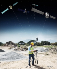
Figure 13: Surveying using satnav with EGNOS and Galileo satellites [image credit: GSA (GNSS Supervisory Agency), Europe]
Our new GIDAS (GNSS Interference Detection and Analysis System) is designed to safeguard critical infrastructure against jamming or spoofing, by performing continuous monitoring of key signal bands. By doing so, GIDAS can raise the alarm in realtime, identify the type of interference then pinpoint the location of these dangerous portable devices causing the interference so the authorities can take immediate remedial action.”
GIDAS can provide interference detection and directionality with a single reporting station, although a minimum of three stations are required for pinpointing interference sources, linked to an overall monitoring center. Monitoring centers can also be connected together, making the GIDAS system easily scalable, from safeguarding an individual harbor, airport or system critical site up to an entire city or region.

Figure 14: Safeguarding satnav (image credit: OHB Digital Solutions)
“People are only now catching up to the seriousness of this problem,” adds Andreas. “Surveys of the highest-density parts of Europe surveys report around three to four jammers hourly.

Figure 15: GIDAS reporting station. GIDAS can provide interference detection and directionality with a single reporting station, although a minimum of three stations are required for pinpointing interference sources, linked to an overall monitoring center (image credit: OHB Digital Solutions)
“These small devices are technically illegal but are easily available online for a few hundred euros or less, often marketed as ‘personal privacy devices’. Jammers are sold as having a range of only a few meters, but can turn out to have a practical range of dozens of meters or more – leading to unintentionally widespread interference, like the famous jammer-equipped US truck driver who shut down Newark Airport navigation systems whenever he drove past.

Figure 16: Jamming devices are technically illegal but are easily available online for a few hundred euros or less, often marketed as ‘personal privacy devices’. Jammers are sold as having a range of only a few meters, but can turn out to have a practical range of dozens of meters or more – leading to unintentionally widespread interference (image credit: OHB Digital Solutions)
“Spoofing is more serious still, with a strong criminal element, where false satellite navigation signals replace real ones, to mislead receivers about their position, employed in the past to down put drones or divert boats.
“Working in this field for eight to nine years, we have seen a strong growth in interference, even as GNSS becomes ever more crucial. With our passion for GNSS and signal processing, we decided to something practical to combat this development, delivering rapid detection, classification and localization of interference to our customers.”
GIDAS was developed by OHB Digital Solutions and Joanneum University through ESA’s Navigation Innovation and Support Program (NAVISP), working with European industry and academia to develop innovative navigation technology.
“The company initiated the project through NAVISP’s second element, focused on strengthening European competitiveness in the navigation arena, proceeding on a co-funded basis,”says engineer Thomas Burger, overseeing GIDAS project for ESA. “The plan was to enable a commercially attractive business to get started, and I’m happy to say we made it.”
“Considering the budget, the project had a wide scope, including the development of a multi-constellation GNSS receiver with all processing stages, an extended digital front end for jamming and spoofing detection, processing blocks transferred to a parallel processor based on a customized fully programmable gate array.

Figure 17: GIDAS dashboard. The new GIDAS is designed to safeguard satnav-reliant critical infrastructure against jamming or spoofing, by performing continuous monitoring of key signal bands. By doing so, GIDAS can raise the alarm in realtime, identify the type of interference then pinpoint the location of these dangerous portable devices causing the interference so the authorities can take immediate remedial action (image credit: OHB Digital Solutions)
“And that was only one ingredient of the overall GIDAS system, also including the actual interference detection machinery, the interference locating subsystem, and all the communication, database, and graphical user interface elements needed to create a distributed, human-usable system – which is able to go on working autonomously, only asking for human involvement when events are detected.”
Following the conclusion of the two-year NAVISP project, GIDAS is now in the process of being rolled out to several Europe-based governmental and private sector customers.

Figure 18: Pinpointing interference (image credit: OHB Digital Solutions)
Figure 19: OHB Digital Solutions GmbH develops systems for monitoring the GNSS frequency bands as well as detection, classification and localization of intentional or unintentional interference sources (video credit: OHB Digital Solutions GmbH)
• April 29, 2020: As European governments plan their phased recoveries from the lockdown states triggered by the COVID-19 pandemic, the positioning delivered through satellite navigation is becoming more important than ever before. Location is a key requirement when attempting to monitor and map the spread of a disease and satnav is one of the main tools supporting this. 30)
- Since the outbreak of the coronavirus earlier this year, many apps have been developed that use satnav-based location data to monitor the global spread of the virus and to map outbreaks of the COVID-19 disease. Satnav based apps are also proving their usefulness by helping people to implement social distancing in queues and other public spaces.
- The Romanian company RISE has developed an app called CovTrack, which monitors people in your vicinity made identifiable via Bluetooth connections to your mobile phone and stores the identification data of these devices.
- By pressing a button you can access the database in which the unique identifiers of the mobile phones are registered (without having access to any personal data of these mobile phone users), to verify whether the persons with whom you came in contact have subsequently been confirmed with COVID-19. If you have identified a potential contact, you can refer to the relevant authorities whether that contact requires your inclusion among the monitored persons, or even testing for COVID-19.
Figure 20: CovTrack Infographic - HD. CovTrack, developed on a pro-bono basis, is a spin-off from the existing AGORA project for festival management, supported through ESA’s Navigation Innovation and Support Program (NAVISP), focused on future navigation technologies (video credit: ESA)
- ESA’s partner agency the GSA, European Global Navigation Satellite System Agency, working with the assistance of the European Commission, has put together a repository of such apps, available here.
- This list, based on apps that are already working and available in app stores, includes practical apps that facilitate the daily lives of citizens, such as by helping them to manage queues in supermarkets, pharmacies and public spaces or by facilitating the logistics of goods, which has become more complicated in the current situation.
- Europe’s Galileo, currently embedded in over 1.3 billion smartphones and devices worldwide, is helping to increase satnav accuracy and availability, especially in urban areas. Is your own smartphone or device making use of Galileo, the most accurate satnav system? You can check here.
- The GSA is also developing its own Galileo-enabled application, Galileo for Green Lane, to monitor and ease the circulation of goods between EU Member States while identifying potential congestion at Green Lane border crossings, and thus ensuring that EU citizens can access the needed supplies of critical goods.
• February 14, 2020: Eutelsat Communications has informed all that the GEO-3 payload of the European Geostationary Navigation Overlay System (EGNOS), a hosted payload aboard the company's EUTELSAT 5 West B satellite, has successfully entered into service. 31)
- EUTELSAT 5 West B is hosting the Eutelsat-procured EGNOS payload under a 15-year agreement that was signed in 2017 with the European Global Navigation Satellite Systems Agency (GSA). The contract also includes technical services and a European ground infrastructure, including two gateways installed at Eutelsat’s Rambouillet and Cagliari teleports.
- Yohann Leroy, Eutelsat’s Deputy CEO and Chief Technical Officer, said that the firm is proud of the collaboration with customer GSA, its partners including the European Space Agency (ESA), and its suppliers, culminating in the entry into service of this next generation technology of EGNOS on EUTELSAT 5 West B. Eutelsat is delighted to host this payload, which will significantly enhance the performance of global navigation satellite systems across Europe, notably Galileo, in the coming years.
- Pascal Claudel, GSA Acting Executive Director and COO, added that with this new payload in service, EGNOS is moving toward the transition to its new generation. This has been done thanks to the constructive collaboration with Eutelsat. Delivery and continuity of satellite services are part of the company's mission as delegated by the European Commission. It is essential that the GSA ensures these services to support economic growth and that the European Union’s citizens and companies can benefit from the latest GNSS technology.
• January 23, 2020: As well as providing global navigation services, Europe’s Galileo satellite constellation is contributing to saving more than 2000 lives annually by relaying SOS messages to first responders. And from now on the satellites will reply to these messages, assuring people in danger that help is on the way. 32)
- This ESA-design ‘return link’ system, unique to Galileo, was declared operational this week, during the 12th European Space Conference in Belgium. The delivery time for the return link acknowledgement messages from initial emergency beacon activation is expected to be a couple of minutes in the majority of cases, up to 30 minutes maximum, depending primarily on the time it takes to detect and locate the alert.
- “Anyone in trouble will now receive solid confirmation, through an indication on their activated beacon, informing them that search and rescue services have been informed of their alert and location,” explains ESA’s Galileo principal search and rescue engineer Igor Stojkovic. “For anyone in a tough situation, such knowledge could make a big difference.”
- All but the first two out of 26 Galileo satellites carry a Cospas-Sarsat search and rescue package. At only 8 kg in mass, these life-saving payloads consume just 3% of onboard power, with their receive-transmit repeater housed next to the main navigation antenna.
- Founded by Canada, France, Russia and the US in 1979, Cospas-Sarsat began with payloads on LEO (Low Earth Orbiting) satellites, whose rapid orbital motion allows Doppler ranging of distress signals, to pinpoint their location. The drawback is these fly so close to Earth that their field of view is comparatively small.
- GEO (Geostationary Earth Orbiting) satellites went on to host Cospas-Sarsat payloads. These see much more of the planet, but because they are motionless relative to Earth’s surface, Doppler ranging is not possible.
- MEO (Medium Earth Orbiting) satellites such as Galileo – orbiting at 23,222 km altitude – offer the best of both worlds, providing a wide ground view by multiple satellites combined with time-of-arrival and Doppler ranging techniques to localize SOS signals. This improves the maximum signal detection time from four hours to less than five minutes, down to 1 or 2 km (within a formal specification of 5 km within 10 minutes).
- Galileo’s Search and Rescue service is Europe’s contribution to Cospas-Sarsat, operated by the European GSA (Global Navigation Satellite System Agency), and designed and developed at ESA. As the overall Galileo system architect and design authority, ESA has been responsible for the interface between the core Galileo infrastructure to the Return Link Service Provider facility, procured by the European Commission and operated by French space agency CNES.
- The Cospas-Sarsat satellite repeaters are supplemented by a trio of ground stations at the corners of Europe, known as Medium-Earth Orbit Local User Terminals (MEOLUTs), based in Norway’s Spitsbergen Islands, Cyprus and Spain’s Canary Islands and coordinated from a control center in Toulouse, France. This trio is soon to become a quartet, with a fourth station on France's La Reunion Island in the Indian Ocean under development.
- The satellites relay distress messages to these MEOLUTs, which then relay them to local search and rescue authorities.
- The service’s return link message capability was developed as an inherent part of the Galileo system. The messages are relayed to the individual beacons that sent the original distress call by being embedded within Galileo signals broadcast from satellites in their view.
- “The switching on of the return link service was enabled by a thorough test campaign carried out by ESA, with the support of the GSA and CNES,” adds Igor. “We needed to be sure the service remains reliable even with multiple distress calls being replied to at once.”
- A key milestone was a public demonstration of the return link service, performed at the Cospas-Sarsat Joint Committee Meeting in Doha in Qatar last summer.
- “The return link is a joint service of Cospas-Sarsat and Galileo and therefore agreement by Cospas-Sarsat was crucial,” adds Igor.
- “This acceptance was achieved through long discussions led by the European Commission at the Cospas-Sarsat Council last November, supported by plentiful documentation of simulations and test results provided by ESA and CNES.”
Figure 21: GALILEO : Reaching you faster – when every minute matters. Search and Rescue (SAR) operations involve locating and helping people in distress. They can be carried out in a variety of locations including at sea, in mountains or deserts, and in urban areas. With the launch of Initial Services, Galileo will help SAR operators respond to distress signals faster and more effectively while also lowering their own exposure to risk ... (video credit: European Commission)
Note: This 'Mission Status' entry of January 23, 2020 is repeated below at Status of Galileo's SAR (Search & Rescue) Service.
• December 20, 2019: The Galileo satellite navigation system has been providing Initial Services for three years now. Meanwhile Europe’s other satnav system has marked its tenth anniversary: EGNOS has been delivering enhanced positioning to users across our continent, including safety-critical services such as aircraft landings for a growing number of European airports. 33)
- The purpose of EGNOS (European Geostationary Navigation Overlay Service) is to monitor the real-time performance of US GPS satellites, then generate a correction message, containing information on the reliability and accuracy of their positioning data, which are then broadcast via EGNOS’s geostationary satellites to all suitably equipped satnav receivers.

Figure 22: The purpose of EGNOS is to monitor the real-time performance of US GPS satellites, then generate a correction message, containing information on the reliability and accuracy of their positioning data, which are then broadcast via EGNOS’s geostationary satellites to all suitably equipped satnav receivers. EGNOS consists of three geostationary satellites and a Europe-wide ground segment composed of two master control stations, six uplink stations and a network of 40 monitoring stations, all connected and communicating in real time (image credit: ESA)
- The end result is a several-fold increase in positioning accuracy and reliability – which is expressed for aviation users through the notion of its ‘integrity’ – how much can it relied upon at any given time. EGNOS typically allows users in Europe and beyond to determine their position to within 1.5 meters with a very high level of integrity, allowing aircraft to be safely guided down to airport runways.
- EGNOS consists of three geostationary satellites and a Europe-wide ground segment composed of two master control stations, six uplink stations and a network of 40 monitoring stations, all connected and communicating in real time.
- EGNOS was a joint project of ESA, the European Commission and Eurocontrol, the European Organisation for the Safety of Air Navigation. The system’s Open Service began on 1 October 2009, after which EGNOS positioning data became freely available in Europe through satellite signals to anyone equipped with an EGNOS-enabled GPS receiver.
- The system is employed for accuracy and integrity-hungry satnav applications such as precision farming, surveying and transport. EGNOS is, for instance, used within the new eCall system, found in all new cars sold in the EU since March 2018. Whenever a serious accident occurs, eCall automatically passes the incident location to the emergency services, with EGNOS providing added accuracy and integrity.

Figure 23: EGNOS for precision farming. EGNOS is employed for accuracy and integrity-hungry satnav applications such as precision farming, surveying and transport (image credit: GSA)
- But as the European equivalent of the US Wide Area Augmentation System WAAS, EGNOS was primarily designed to serve aviation, specifically for the safety-critical task of guiding down aircraft for landings. This became possible on 2 March 2011, when EGNOS’s ‘Safety-of-Life’ service began to operate.
- Today more than 350 airports - more than half of the total – across Europe employ EGNOS. To do so, they have been certified for what are known as ‘LPV-200 procedures’ allowing pilots to take their aircraft down to 60 m (200 ft) above the ground for a final go/no-go decision on continued landing descent. LPV stands for ‘localizer performance with vertical guidance’.
- This certification allows airports to operate without costly ground-based Instrument Landing System ‘Cat-1’ infrastructure. Major airports hubs such as Paris Charles de Gaulle, Frankfurt and Amsterdam Schiphol employ EGNOS for landing approaches. For smaller regional airports, EGNOS allows them to stay open in all weathers.

Figure 24: Aircraft pilots are making use of EGNOS for what are known as ‘approach with vertical guidance’ procedures at suitably certified European airports. They can provide vertical guidance down to within 60 m altitude of given runways in all weather and conditions, at which point the pilot does the rest (image credit: GSA)
Figure 25: As of April 2018 all new cars will be equipped with eCall technology. In the event of a serious accident, eCall automatically dials 112 - Europe's single emergency number - to provide faster assistance and save lives (video credit: GSA)
- The EGNOS Exploitation Program is managed by the European Global Navigation Satellite System Agency, GSA. ESA retains the role of developing its future System evolution, taking shape as ‘EGNOS V3’ in the coming decade, which will augment signals from both GPS and Galileo satellites for added performance, reliability and extended coverage.
Figure 26: EGNOS augmenting satellite navigation (video credit: ESA)
• July 22, 2019: The Initial Services provided by the European satellite navigation system - Galileo - have been successfully restored. Galileo was affected by a technical incident related to its ground infrastructure. This event led to a temporary interruption of the globally available Galileo navigation and timing services, with the exception of the Galileo Search and Rescue Service. 34)
- The Search and Rescue Service, which is used to locate and assist people in emergency situations, for example, at sea or in remote, mountainous areas, was not affected and remained operational.
- The navigation service impact was caused by a malfunction of some equipment in the Galileo control centers, which generate the system time and calculate orbit predictions; these data are used to produce the navigation messages. The disruption affected various elements at the control centers in Fucino (Italy) and at the DLR site in Oberpfaffenhofen.
- A team of experts from the Galileo Service Operator, led by Spaceopal GmbH, worked as quickly as possible and in close cooperation with the European GNSS Agency (GSA), as well as the industrial ground infrastructure providers together with the European Space Agency (ESA) to rectify the malfunction.
- Due to the high technical complexity of the system and the in-depth analysis of the fault dependencies, these efforts took several days before the resumption of Initial Services on 18 July 2018.
- An independent board of inquiry is now investigating the exact circumstances and root causes that led to the failure. The investigation is being conducted by the EU Commission and the GSA - the authorities that manage the program - in order to continuously improve the system during its initial service phase.
- Galileo has been offering its Initial Service since December 2016. During this initial 'pilot' phase, which precedes the 'full-operational services' phase, Galileo signals are being used also in combination with those from other satellite navigation systems, allowing testing and the detection of potential technical challenges during the commissioning of the system until full deployment and operational capability has been reached.
• July 18, 2019: Galileo Initial Services have now been restored. Commercial users can already see signs of recovery of the Galileo navigation and timing services, although some fluctuations may be experienced until further notice. 35)
- The technical incident originated by an equipment malfunction in the Galileo control centers that calculate time and orbit predictions, and which are used to compute the navigation message. The malfunction affected different elements on both centers.
- A team composed of GSA (Global Navigation Satellite Systems Agency) experts, industry, ESA and Commission, worked together 24/7 to address the incident. The team is monitoring the quality of Galileo services to restore Galileo timing and navigation services at their nominal levels.
- We will set an Independent Inquiry Board to identify the root causes of the major incident. This will allow the Commission, as the program manager, together with the EU Agency GSA to draw lessons for the management of an operational system with several millions of users worldwide.
- Galileo provides ‘initial services’ since December 2016. During this initial ‘pilot’ phase preceding the ‘full operational services’ phase, Galileo signals are used in combination with other satellite navigation systems, which allows for the detection of technical issues before the system becomes fully operational. In the full operational phase, Galileo should function independently of other satellite navigation systems.
• July 17, 2019: A team of experts from the European GNSS Agency, industry, the European Space Agency and the European Commission is currently implementing and monitoring recovery actions for an incident related to the Galileo ground infrastructure that resulted in a temporary interruption of the Galileo Initial Services. The key objective is to restore the Galileo navigation and timing services for users as soon as possible. 36)
- On 12 July, Galileo initial navigation and timing services were interrupted temporarily. The Galileo Search and Rescue service remains operational.
- Galileo is widely used by most of the commercially available receivers. Multi-constellation GNSS receivers will remain unaffected and compute position and timing using other constellations. Galileo-only receivers will not produce any navigation message.
- As soon as the incident was declared, an Anomaly Review Board was convened and urgent recovery procedures were activated in the affected Galileo infrastructures. Operational teams are working on recovery actions 24/7 to restore the Galileo navigation and timing services as soon as possible.
- Based on the results of the troubleshooting activities, several elements of the ground infrastructure were re-initiated. The progress is being closely monitored; it is too early to confirm an exact service recovery date.
A period for testing and perfecting
- The Galileo satellite navigation system launched its Initial Services in December 2016 and since then it has been providing high quality positioning, navigation and timing services to users worldwide. The aim of this Initial Services phase is to allow for the detection of technical issues before the system becomes fully operational.
- It was precisely to deal with issues of this nature that the EU opted for a progressive roll-out of the Galileo system. The evolution and planned upgrade of the ground infrastructure will reinforce redundancy of the system towards reaching the full operations phase.
- As soon as the outage occurred, the users were informed by the Galileo Service Center through technical notices on 11 and 13 July , as well as a news item on the GSA website on 14 July. Users will be regularly updated, including on the navigation and timing service recovery date, through notifications and information.
- The Galileo team would like to assure users that it is working hard to remedy the situation as soon as possible.
• July 14, 2019: Galileo, the EU's satellite navigation system, is currently affected by a technical incident related to its ground infrastructure. The incident has led to a temporary interruption of the Galileo initial navigation and timing services, with the exception of the Galileo Search and Rescue (SAR) service. The SAR service - used for locating and helping people in distress situations for example at sea or mountains - is unaffected and remains operational. 37)
- Galileo provides ‘initial services’ since December 2016. During this initial "pilot" phase preceding the ‘full operational services’ phase, Galileo signals are used in combination with other satellite navigation systems, which allows for the detection of technical issues before the system becomes fully operational.
- Experts are working to restore the situation as soon as possible. An Anomaly Review Board has been immediately set up to analyze the exact root cause and to implement recovery actions.
- As foreseen in case of technical incidents, information Notices to Galileo Users (NAGU) were already published on the Galileo Service Center website:
a) on 11 July 2019: https://www.gsc-europa.eu/notice-advisory-to-galileo-users-nagu-2019025
b) and on 13 July 2019 : https://www.gsc-europa.eu/notice-advisory-to-galileo-users-nagu-2019026
c) https://www.gsc-europa.eu/system/files/galileo_documents/Galileo-service-notice-02.pdf
- Users will be informed regularly, including on the service recovery date.
• June 11, 2019: Europe’s students and young researchers were challenged to design a smartphone app to take advantage of Galileo’s dual-frequency signals. Run by ESA in collaboration with the European Global Navigation Satellite Systems Agency – GSA – plus the European Commission with the support of Google, a total of five teams made it to the final of the Galileo smartphone app competition 2019 which took place at ESA’s ESTEC technical heart in the Netherlands on Thursday 18 April. This event was preceded by testing the performance of the competing apps in static, pedestrian and driving use modes. 38)
Figure 27: We are Europe's gateway to space. Our mission is to shape the development of Europe's space capability and ensure that investment in space continues to deliver benefits to the citizens of Europe and the world (video credit: ESA, Uploaded on 11 June 2019)
• March 4, 2019: Global leader in emergency readiness and response, Orolia, is pleased to announce that its McMurdo FastFind 220 and Kannad SafeLink Solo PLBs (Personal Location Beacons) now operate with the Galileo GNSS system. 39)
- Continuing Orolia's innovation and leadership role in Safety Electronics, the PLBs have been upgraded to include Galileo Global Navigation Satellite System (GNSS), the European Union's global satellite constellation.

Figure 28: These are the world's first PLBs utilizing the Galileo satellites' capabilities and are the first of a series of new solutions coming from the EU-funded Helios project, led by Orolia, which has been set up to leverage the power of the new satellite system (image credit: Orolia)
- The multi-constellation receivers work with a wider range of satellites, offering increased global coverage and supporting accelerated rescue missions.
- Location detection is enhanced and can be more precise due to the beacons receiving coordinates from the Galileo satellite network in addition to the tried and tested GPS network. Signals can even be detected in high sided locations, such as canyons.
- "We are thrilled to be launching our upgraded PLBs in the European and US markets," said Chris Loizou, Vice President of Maritime at Orolia.
- "The combination of both Galileo and GPS GNSS capability means that our customers will benefit from coverage that spans from the North to the South Pole. We work tirelessly to push the boundaries of product innovation and, ultimately, to give people the best chance of being rescued in an emergency situation."
- The McMurdo FastFind and Kannad SafeLink PLBs are part of Orolia's comprehensive search and rescue ecosystem and join the McMurdo SmartFind G8 and Kannad SafePro series EPIRBs (Emergency Position Indicating Radio Beacons) as the first Galileo capable rescue beacons.
- As the world's only provider of an end-to-end search and rescue ecosystem - including distress beacons, satellite ground stations, mission control and rescue coordination systems, and rescue response products - Orolia's McMurdo brand uniquely builds, integrates and tests products as part of a live search and rescue system.
- This ensures greater cohesion between distress signal transmission and reception so that beacon owners can feel confident that their signals will get to search and rescue authorities quickly.
• February 7, 2019: The latest four Galileo satellites, launched on 25 July 2018, have been given the green light to begin working alongside the rest of Europe’s satellite navigation fleet, giving a further boost to worldwide Galileo service quality. 40)
- Galileo has grown to become Europe’s single largest satellite constellation, built up over 10 launches over the course of this decade. The first of seven double-satellite Soyuz launches took place in 2011, with three sets of four-satellite Ariane-5 launches during the last three years. — The latest quartet of Galileo satellites were launched together by Ariane 5 on 25 July, bringing the number of satellites in orbit to 26.

Figure 29: Europe's Galileo navigation satellites orbit 23 222 km above Earth to provide positioning, navigation and timing information all across the globe (image credit: GSA)
• December 17, 2018: Use Europe’s satellite navigation system to seek treasure in virtual mazes or ‘see’ Galileos as they cross the sky above you: two new Android smartphone apps based on Galileo are now available for general download, the results of a competition by ESA trainees. 41)
- With newer Android smartphones you can access the raw signal measurements used to compute position, opening the door to the development of applications where the user can indeed select which satellites to use. So ESA ran an internal competition for its trainees to develop an app capable of making positioning fixes using only Galileo satellites.
- The Callisto – Galileo’s Spaceship app uses Galileo satnav signals to run a virtual maze game based on walking through a real world location.
- Looking down on Earth as if from a spaceship, players use a standard Google map display to traverse a rectangular area filled with randomly generated obstacles and collectibles. You play against the clock to grab prizes, with points deducted for running into virtual barriers.
- “It was fun for us to develop as a team, but one of the main purposes behind it was to spread the message about Galileo,” explains ESA young graduate trainee Peter Vanik, part of the five-person ‘Chocolateam’ that created the app.
- “Users can use signals from the Galileo constellation by itself, GPS by itself or GPS and Galileo in combination to get a sense of the different accuracy levels – the combination of constellations will work best, because that way the most satellites are available for use.”
- The team used online tutorials and YouTube videos to learn how to develop for Android, with their satnav backend derived from GNSSCompare – the winning app from ESA’s internal competition, offering to turn a smartphone in a ‘research lab in your pocket’.
- None of us are satnav specialists, so we played off not knowing all the nitty-gritty as an advantage rather than a weakness, in terms of targeting the general public,” adds Matej Poliaček of the Callisto team.
- “The idea of a game came up early on, with a satnav-based gameplay loop,” says the team’s Cedric Ia. “Then Lionel Garcia, our designer, had the idea of making it spaceship-based, and that was where the design for our user interface came from.”
- “Working together with GNSSCompare was a way to combine the best of both worlds,” explains team member Emilie Udnæs. “They’re stronger on the GNSS side of things while we took a user-centered approach.
- The Callisto app was designed on and for a Galaxy S8 smartphone, but the team is expanding the app to serve as many different phones as possible, to target a general public audience.
- Another app developed through the competition is also available for download from Google Play. GalileoPVT was created by ESA navigation engineer Paola Crosta and electrical engineer Tim Watterton to serve as a benchmark to judge competition entries. The duo went on to finalize and publish it.
- “GalileoPVT allows users to compare position fixes calculated from Galileo and GPS signals, and also to visualize Galileo satellites and signals live in the sky using augmented reality,” explains Tim.
- “The raw signals can be saved for post-processing by users. There’s also a fun hidden game, where the player has to maneuver their Galileo satellite to avoid increasingly bizarre items of space debris, aided by received Galileo signals that boost their satellite’s health.”
- “GalileoPVT can also be installed on devices that do not support Galileo signals. Although the user will not be able to receive the live Galileo signals or calculate a fix with Galileo, they can still see the predicted satellite positions on the augmented reality view, and play the hidden game.”
- A current list of smartphones that support Galileo can be found here.

Figure 30: The GalileoPVT app allows users to compare position fixes calculated from Galileo and GPS signals, and also to visualize Galileo satellites and signals live in the sky using augmented reality. It also features a hidden game (image credit: ESA)

Figure 31: An augmented reality view of a Galileo satellite above Cape Town, South Africa. Space engineer Frank Bagiana took a smartphone equipped with the GalileoPVT app during his holiday to Africa to take some pictures of Europe's navigation satellites. Satellites in green are contributing to the receiver's positioning solution (image credit: ESA)
• December 4, 2018: Galileo satellites measure Einsteinian Time Dilation.Europe’s Galileo satellite navigation system – already serving users globally – has now provided a historic service to the physics community worldwide, enabling the most accurate measurement ever made of how shifts in gravity alter the passing of time, a key element of Einstein’s Theory of General Relativity. 42)
Two European fundamental physics teams working in parallel have independently achieved about a fivefold improvement in measuring accuracy of the gravity-driven time dilation effect known as ‘gravitational redshift’.
The prestigious Physical Review Letters journal has just published the independent results obtained from both consortiums, gathered from more than a thousand days of data obtained from the pair of Galileo satellites in elongated orbits. 43)

Figure 32: The relativistic eccentricity of Galileo satellites 5 and 6 reaches a peak amplitude of approximately 370 nanoseconds (billionths of a second), driven by the shifting altitude, and hence changing gravity levels, of their elliptical orbits around Earth. A periodic modulation of this size is clearly discernible, given the relative frequency stability of the PHM (Passive Hydrogen Maser) atomic clocks aboard the satellites (image credit: ESA)
It is most satisfying for ESA to see that our original expectation that such results might be theoretically possible have now been borne out in practical terms, providing the first reported improvement of the gravitational redshift test for more than 40 years,” comments Javier Ventura-Traveset, Head of ESA’s Galileo Navigation Science Office.
“These extraordinary results have been made possible thanks to the unique features of the Galileo satellites, notably the very high stabilities of their onboard atomic clocks, the accuracies attainable in their orbit determination and the presence of laser-retroreflectors, which allow for the performance of independent and very precise orbit measurements from the ground, key to disentangle clock and orbit errors.”

Figure 33: Galileo satellites 5 and 6 were delivered into faulty elongated orbits by a faulty Soyuz upper stage during their launch in 2014. This left them unable to view the entire Earth disc during the low point or perigee of their orbits, rendering their navigation payloads unusable, because they use an Earth sensor to center their signal beams. Subsequent orbital maneuvers succeeded in making their orbits more circular and their navigation payloads usable because they retained views of the entire Earth disc through each orbit. However their orbits remain elliptical compared to the rest of the Galileo constellation. Bottom view from orbital plane of nominal orbit (in blue) and injected orbit (in green) for the pair (image credit: ESA)
These parallel research activities, known as GREAT (Galileo gravitational Redshift Experiment with eccentric sATellites), were led respectively, by the SYRTE Observatoire de Paris in France and Germany’s ZARM Center of Applied Space Technology and Microgravity in Bremen, coordinated by ESA’s Galileo Navigation Science Office and supported through its Basic Activities.
Welcome results from an unhappy accident
These findings are the happy outcome of an unhappy accident: back in 2014 Galileo satellites 5 and 6 were stranded in incorrect orbits by a malfunctioning Soyuz upper stage, blocking their use for navigation. ESA flight controllers moved into action, performing a daring salvage in space to raise the low points of the satellites’ orbits and make them more circular.
Once the satellites achieved views of the whole Earth disc their antennas could be locked on their homeworld and their navigation payloads could indeed be switched on. The satellites are today in use as part of Galileo search and rescue services while their integration as part of nominal Galileo operations is currently under final assessment by ESA and the European Commission.
However, their orbits remain elliptical, with each satellite climbing and falling some 8500 km twice per day. It was these regular shifts in height, and therefore gravity levels, which made the satellites so valuable to the research teams.

Figure 34: Albert Einstein lecturing in Vienna in 1921 (image credit: Public domain)
Reenacting Einstein’s prediction
Albert Einstein predicted a century ago that time would pass more slowly close to a massive object, a finding that has since been verified experimentally several times – most significantly in 1976 when a hydrogen maser atomic clock on the Gravity Probe-A suborbital rocket was launched 10,000 km into space, confirming Einstein’s prediction to within 140 parts per million.
In fact, atomic clocks aboard navigation satellites must already take into account the fact that they run faster up in orbit than down on the ground – amounting to a few tenths of a microsecond per day, which would result in navigation errors of around 10 km daily, if uncorrected.

Figure 35: The Gravity Probe A payload of 1976, flown in a highly elliptic single orbit to measure the ‘gravitational redshift’ of Einstein’s Theory of General Relativity more accurately than ever before, seen with its designers Robert Vessot and Martin Levine of the Smithsonian Astrophysical Observatory. The experiment compared a hydrogen maser clock on Earth with its replica in space as it ascended to about 10,000 km, and confirmed theoretical expectations to an accuracy of 0.02% (https://einstein.stanford.edu)

Figure 36: Periodic modulation of the gravitational redshift for one day's orbit of the eccentrically-orbiting Galileo satellites (image credit: ESA)
The two teams relied upon the stable timekeeping of the PHM (Passive Hydrogen Maser) clocks aboard each Galileo – stable to one second in three million years – and kept from drifting by the worldwide Galileo ground segment.
“The fact that the Galileo satellites carry passive hydrogen maser clocks, was essential for the attainable accuracy of these tests,” noted Sven Hermann at the University of Bremen’s ZARM Center of Applied Space Technology and Microgravity. “While every Galileo satellite carries two rubidium and two hydrogen maser clocks, only one of them is the active transmission clock. During our period of observation, we focus then on the periods of time when the satellites were transmitting with PHM clocks and assess the quality of these precious data very carefully. Ongoing improvements in the processing and in particular in the modelling of the clocks, might lead to tightened results in the future.”
Refining the results
A key challenge over three years of work was to refine the gravitational redshift measurements by eliminating systematic effects such as clock error and orbital drift due to factors such as Earth’s equatorial bulge, the influence of Earth’s magnetic field, temperature variations and even the subtle but persistent push of sunlight itself, known as ‘solar radiation pressure’.
“Careful and conservative modelling and control of these systematic errors has been essential, with stabilities down to four picoseconds over the 13 hours orbital period of the satellites; this is four millionth of one millionth of a second,” Pacôme Delva of SYRTE Observatoire de Paris. “This required the support of many experts, with notably the expertise of ESA thanks to their knowledge of the Galileo system.”

Figure 37: Passive hydrogen maser atomic clock of the type flown on Galileo, accurate to one second in three million years (image credit: ESA)
Precise satellite tracking was enabled by the International Laser Ranging Service, shining lasers up to the Galileos’ retro-reflectors for centimeter-scale orbital checks.
Major support was also received from the Navigation Support Office based at ESA's ESOC operations center in Germany, whose experts generated the reference stable clock and orbit products for the two Galileo eccentric satellites and also determined the residual errors of the orbits after the laser measurements.

Figure 38: Satellite laser ranging station at Potsdam GFZ in Germany, part of a worldwide network known as the International Laser Ranging Service (image credit: DLR)
• November 9, 2018: ESA is setting up a new GSSC (GNSS Science Support Center) facility at ESA's ESAC (European Space Astronomy Center) near Madrid, Spain. Run by ESA’s Galileo Science Office, the GSSC integrates IT and satnav infrastructure to deliver advanced data processing services to the scientific community. 44)
- Precisely timed to a few billionths of a second and highly stable, satnav signals can be used as a point of reference for many scientific sectors, including Earth and atmospheric sciences, astronomy, highly precise timing ‘metrology’ as well as the study of relativity and other fundamental physics topics.

Figure 39: Photo of ESA's GSSC facility at ESAC, near Madrid (image credit: ESA)
- Current satnav infrastructure plans worldwide should see more than 120 satnav satellites in orbit in coming years. This number includes Europe’s own Galileo constellation – offering unique features such as its highly stable passive hydrogen maser atomic clocks, multiple transmission frequencies, robust modulation, wide bandwidth and onboard laser retro-reflectors, which permit exact pinpointing of the satellites’ position in space down to a few tens of centimeters.
- “The potential of satnav for science has been recognized for a long time,” explains Javier Ventura-Traveset, Head of ESA’s Galileo Science Office. “The Galileo Science Office was set up in 2016 as a joint initiative between ESA’s Science and Navigation Directorates, coordinating scientific opportunities through interaction with the scientific community and the independent GNSS Science Advisory Committee.
- “The opening of the new center is the next step. It is ESA’s concrete answer to the need expressed by the scientific community for a ‘one-stop-shop’ to offer researchers long-term GNSS data, products information, results of scientific experiments, plus services to enhance GNSS scientific research and collaboration.
- “The future evolution of the center will be driven by the interaction and feedback received from the scientific community, maximizing synergies with other GNSS data service providers from other institutions and research organization.”
- Among the activities to be supported by the new GSSC are big data processing of large amounts of satnav data, crowdsourcing as a means of weather monitoring and a scientific assessment of satnav performance in Antarctica.
- It also supports the continuing measurements of general relativity using Galileo satellites 5 and 6 and serves as a global data center for the International GNSS Service. The long-established Navipedia website, giving technical information on satnav, is also hosted by the GSCC.
- One enthusiastic early adopter is ESA’s Navigation Support Office, based at ESA’s ESOC mission control center in Darmstadt, Germany, lending support to mission teams making use of satnav to steer satellites.
- “The GSSC is a welcome addition to ESA’s activities in the science of satellite navigation,” says Werner Enderle, heading ESOC’s Navigation Support Office. “The GSSC already hosts GNSS products generated by the team at ESOC, including observations from our worldwide EGON GNSS Observation Network and precise satellite orbits generated by their state-of-the-art software. Our two teams look forward to this collaboration continuing for the benefit of ESA and the scientific community.”
- The GSSC will roll out access to data, products and services over the coming months.
• October 18, 2018: Europe’s 26 navigation satellites in orbit are providing Galileo Initial Services – available to users around the globe since 2016 – and a new ESA contract signing means these services will be delivered on a more accurate basis and more securely than ever. 45)
- ESA has awarded a new framework contract and two new work orders to Thales Alenia Space in France, to upgrade the Galileo Mission Segment – that element of the worldwide Galileo ground segment dedicated to delivering navigation services – and the Galileo Security Monitoring Center (GSMC) near Paris, as well as to implement a second GSMC in Spain, near Madrid.
- ESA Director of Navigation Paul Verhoef signed the contract with Thales Alenia Space Senior Vice President of Sales Martin van Schaik on 17 October 2018 at ESA/ESTEC in Noordwijk, the Netherlands.
- “Galileo has already proven to be the highest performing satellite navigation system in the world, even before the constellation is complete,” the ESA Director commented. “This achievement is the result of the close collaboration between the public sector – the European Commission, the European GNSS Agency and ESA – and our industrial partners throughout Europe.
- “Today I am very happy to announce a continued relationship with Thales Alenia Space in one of the most complex parts of the system, namely the Ground Mission Segment, and thank them for their commitment to the program.”
- The constellation in orbit is only one element of the overall satellite navigation system – the tip of the Galileo iceberg. At the same time as the satellites were being built, tested and launched, a global ground segment was put in place.
- Establishing Galileo’s ground segment was among the most complex developments ever undertaken by ESA, having to fulfil strict levels of performance, security and safety. Last year responsibility for operating the Galileo ground segment was passed to ESA’s partner organization, the European GNSS Agency (GSA). Nevertheless, ESA continues to be in charge of the maintenance, development and evolution of the ground segment, as well as the development of the space segment (see Figure 75).

Figure 40: Surveyor using a GNSS device to map urban assets using Galileo and EGNOS (image credit: GSA)
• October 2018: Galileo has made significant progress in recent years: twenty-six Galileo satellites are now orbiting the Earth, a significant part of the supporting ground station infrastructure has been deployed, and the European GSA (GNSS Supervisory Agency) has assumed the role of the Galileo Service Provider. 46)
- With the Declaration of Galileo Initial Services on the 15th of December 2016, the transition of Galileo from the testing and deployment phase to a system in service has started, and Galileo is now ready to be used. During this Initial Services provision phase, deployment activities towards Full Operational Capability continues in parallel. To support this service phase, the GSA has established a new service facility called the GRC (Galileo Reference Center) in Noordwijk, the Netherlands.
• September 21, 2018: Since the launch of Initial Services in December 2016, Galileo has been providing more and more users with global positioning, navigation and timing information. Behind this increase in use is the wide array of Galileo-enabled devices and services that have entered the market – including over 60 smartphone models in the past two years. Furthermore, as of April, all new types of cars sold in the EU must be equipped with Galileo as required by the eCall regulation. Galileo is also being increasingly used in drones to ensure smooth navigation and in Search and Rescue operations to save lives. 47)
- With this increased interest in Galileo, both the general public and industry want to know what devices are Galileo-capable.
- As new devices are constantly being added to the list, the GSA launched an enhanced version of its popular UseGalileo.eu website. The site allows users to easily search and keep track of Galileo-enabled devices as they become available.
- The enhanced site includes new categories covering applications in the timing, Internet of Things (IoT) and space application segments. Furthermore, other categories, such as aviation, emergency services and agriculture, now include a number of sub-categories. For example, within the aviation segment, users can narrow their search to Galileo-enabled devices and applications for avionics, airports and Unmanned Aerial Vehicles (UAVs). Flight operators can even search per their particular aircraft, whether that be a business jet, a helicopter or a commercial airliner.
- “We are proud to see how quickly Galileo is being embraced by European citizens and businesses,” says GSA Executive Director Carlo des Dorides. “The enhanced UseGalileo site and its many segment-specific search functions is another example of how we keep the user at the center of European GNSS.”
• September 18, 2018: An app that lets your smartphone work directly with Galileo and check performance from raw satellite signal measurements is now available for download from the Google Play Store. 48)
- Developed by ESA trainees in their spare time, the GNSS Compare app was the winner of an internal ESA competition this summer.
- “GNSS Compare is an open source tool making the lives of satnav developers and researchers easier,” explains ESA young graduate trainee Mateusz Kraiński from Poland, who led the four-person ‘Galfins’ development team. “We think of it as a research lab in your pocket.”
- Mateusz explains that the new app shows details of which satellites your phone is using to perform its positioning, velocity and timing (PVT) calculations, along with their relative signal strength.
- “You can also choose between Galileo-only, GPS-only or Galileo plus GPS, as well as altering processing settings, to see how the positioning performance changes as a result – or else put your own prototype processing algorithms to the test. - In the past you would have to do this with expensive receivers or software-defined radios, but GNSS Compare lets users perform checks in a very simple way, using just the hardware in their pocket. It also has an educational aspect, because users can really ‘look under the hood’ and see for themselves how the PVT process works in practice.”
- The receiver chipsets inside smartphones compute positioning using multiple satellite constellations without regard for which satellites’ signals are used, giving results but with no insight into how they are calculated, or the opportunity to choose which satellites to employ.
- The GNSS Compare app was made possible by the fact that newer Android smartphones can access the raw satellite signal measurements used to compute positioning.

Figure 41: The winning Galfins team of ESA's Galileo smartphone app flanked by members of the other two teams of ESA trainees, ‘Chocolateam’ and ‘Team 5G’, at the end of the competition's final presentation at ESA's ESTEC technical center on 31 May 2018. At the far left is Riccardo De Gaudenzi, head of ESA's Radio Frequency Systems and Payloads Office; to the far right is Javier Benedicto, ESA’s Galileo program manager (image credit: ESA–G. Porter, CC BY-SA 3.0 IGO)
- “Last year, we took advantage of this change to introduce our inaugural Galileo Smartphone App Competition,” says Nityaporn Sirikan of ESA’s Navigation Directorate. We challenged ESA trainees to develop an app to perform satnav fixes using solely Galileo satellites,” she explains. “Three teams developed apps in their spare time, each one targeting different user groups. They were judged by a jury of experts from the European Global Navigation Satellite Systems Agency – GSA – and Google as well as ESA. The response was very positive, and we are now planning a second competition.”
- As a trainee at ESA/ESTEC in the Netherlands, Mateusz’s dayjob has been focused on the European Robotic Arm, destined for the International Space Station. His fellow Galfins team trainees are Germany’s Mareike Burba working on Earth observation, Romanian Sebastian Ciuban – the team’s sole Navigation specialist – and Polish-born Dominika Perz, focused on satellite guidance, navigation and control.
- Their prize for winning was attending the ESA and European Commission-sponsored International Summer School on Global Navigation Satellite Systems in Austria.
• July 13, 2018: Europe’s next Galileo satellites have been put in place on top of the Ariane 5 launcher due to lift them from Europe’s Spaceport in Kourou, French Guiana on Wednesday 25 July (Figure 42). 49)
- “In preparation for their launch the four satellites were switched off, apart from their battery charging line and another maintenance power line to their PHM (Passive Hydrogen Maser) atomic clocks,” reports Jean Verniolle, ESA’s Galileo mission director for this launch.
- “Next Galileo satellites 23–26 were integrated one by one on four successive days onto the Galileo dispenser that will hold them securely in place for launch, and to form what we call the launch ‘stack’.”

Figure 42: Galileo quartet placed atop Ariane 5: Galileo satellites 23-26 were lifted to the top of their Ariane 5 launcher inside the BAF ‘Bâtiment d’Assemblage’ building on Wednesday 11 July, ahead of their Wednesday 25 July 2018 launch (image credit: ESA/CNES/Arianespace/Optique Video du CSG - P Baudon)
• July 11, 2018: An augmented reality view of Galileo satellites in the sky close to ESA’s technical center in the Netherlands. It comes from a Galileo-focused satnav app for Android smartphones, developed by ESA engineers. 50)
- ESA ran an internal competition for its trainees to develop an app capable of making positioning fixes using only Galileo satellites.
- “As part of our support for the competition, we developed our own app on a voluntary basis to serve as a benchmark,” explains Paolo Crosta of ESA’s Radio Navigation Systems and Technology section. “We included this augmented reality view, so users can ‘see’ the satellites their smartphone is using as they hold it up to the sky.”
- The positioning calculations and assistance data functions for the app were developed by Paolo, with telecom engineer Tim Watterton contributing the main structure of the app, together with how it looks and its user interface.
- Tim adds: “The satellites are overlaid in real time on the camera view in their predicted positions in the sky, based on ‘ephemeris’ information, assistance data that describes the current satellite orbits with high precision.
- “When a signal is being received, the satellite is shown in green, overlaying the predicted position. The satellite shown in red is one of the two placed in elongated orbits, but these satellites are expected to be used soon in the operational constellation. Satellites colored orange are transmitting, but the signal is not detected, which may be due to obstruction by terrain or buildings.”
- Panning the phone around to position the crosshair over a green colored satellite adds additional information about it, such as its signal status, ‘pseudo-range’ (the uncorrected distance the signal has travelled to reach the receiver) plus the satellite’s manufacturer, launch date among other items. The reference app is now being tested with the hope of making it publicly available on the Android Play Store. The trainees are also testing their own apps following the competition with the goal of releasing them.
- There are 22 Galileo satellites in orbit, with four more satellites set for launch on 25 July.

Figure 43: Galileo satellites viewed in smartphone app (image credit: ESA)
 Galileo FOC Series continued
• July 2, 2018: Europe’s satellite navigation system Galileo is already in use worldwide, usable by itself or in combination with the US Global Positioning System (GPS). Now a combined Galileo–GPS positioning fix has been achieved in space – aboard the International Space Station – through an ESA–NASA collaboration. 51)
- Low-Earth orbiting satellites routinely make use of satellite navigation signals to pinpoint their position in space and allow their paths through space to be fixed with extremely high accuracy, known as ‘precise orbit determination’.
- So far, such positioning has mainly been performed using GPS, but this new test proves it can also be achieved on a dual-constellation basis with both GPS and Galileo – as well as through the sole use of Galileo.
- The experiment is based on the use of a re-configurable NASA receiver called the Space Communications and Navigation Testbed, SCaN, attached to the exterior of the ISS.
- ESA’s Navigation Support Office, based at its ESOC control center in Darmstadt, Germany, teamed up with its Radio Navigation Systems and Technology team, located at its ESTEC technical center in Noordwijk, the Netherlands, and Italy’s NASCOM company to develop the techniques, software and firmware required for the experiment, which was passed to NASA’s Glenn Research Center in Ohio for upload to the receiver.
- “SCaN is a versatile software-defined radio receiver in space for both telecommunications and navigation testing, delivered to the Station back in 2012,” explains ESA radio-navigation engineer Pietro Giordano. “It made it possible, with suitable modifications, to demonstrate combined GPS-Galileo positioning determination of the ISS.”
- The algorithm developed for the SCaN Testbed had to take account of the high dynamics involved, and resulting Doppler shifting of signals: not only are the Galileo and GPS satellites moving at orbital velocity, so is the ISS itself. Orbital information of all the satellites in both constellations was included in the algorithm, allowing SCaN to make a ‘warm start’ – to search out signals in the correct segments of the sky.

Figure 44: SCaN Testbed on ISS: A re-configurable NASA receiver SCaN (Space Communications and Navigation Testbed) is attached to the exterior of the ISS. In April 2018 the chest-sized SCaN, seen left of center with an antenna on top, was used to make the first combined Galileo-GPS positioning fix in orbit (image credit: NASA)
- “Dual constellation fixes offer many advantages for space, providing extremely robust and high-precision positioning,” adds Pietro. “More signals become available overall, and the quality of the Galileo Open service and modernized GPS signals are extremely good.”
- Werner Enderle, overseeing the project at the Navigation Support Office notes: “These excellent first results, coming out of great teamwork within ESA, collaboration with industry and with our NASA partners, mark just the beginning of our project data analysis. Many other exciting results are expected related to signal aspects, precise orbit determination and positioning based on optimized algorithms.”
- James J. Miller, GPS Sr. Technologist within the SCaN program office at NASA Headquarters, comments: “We’ve been promoting interoperability of GPS and Galileo through a number of activities within the United Nation’s International Committee on Global Navigation Satellite Systems (GNSS). In particular, NASA, with ESA and other national space agencies, has been identifying benefits to be gained for high altitude users in the multi-GNSS Space Service Volume under development. By further demonstrating multi-GNSS capabilities in low Earth orbit, the drive for additional utility at geostationary orbit and beyond is only strengthened”.
- Europe’s Galileo system began Initial Services for users in December 2016, and there are 22 Galileo satellites in orbit. The launch of four more Galileo satellites by Ariane 5 is scheduled for 25 July, bringing the constellation to 24 satellites plus two orbital spares.
- ESA is developing dual Galileo-GPS receivers for the next generation of Earth-observing Sentinel satellites. The more precise the orbit determination, the more accurate the environmental data that can be returned to Earth.
- Combined use of Galileo and GPS signals on an interoperable basis for positioning and precise orbit determination should bring significant advantages for space users in particular, set to provide a seamless navigation capability from low to high Earth orbits – and potentially beyond.
- Paul Verhoef, ESA’s Director of Navigation, states: “This shows the versatility of the Galileo system and the use of the system for scientific and other purposes, way beyond traditional navigation services. We have also started work to determine whether we can use Galileo, in combination with GPS and other systems, for navigation to the Moon.”
• June 7, 2018: ESA microwave engineers took apart an entire Galileo satellite to reassemble its navigation payload on a laboratory test bench to run it as though it were in orbit – available to investigate the lifetime performance of its component parts, recreate satellite anomalies, and test candidate technologies for Galileo’s future evolution. 52)
- Located in the cleanroom environment of the Galileo Payload Laboratory – part of ESA’s Microwave Lab based at its ESTEC technical center in the Netherlands – the new Galileo IOV Testbed Facility was inaugurated this week with a ceremony attended by Paul Verhoef, ESA Director of Navigation and Franco Ongaro, ESA Director of Technology, Engineering and Quality.
- Paul Verhoef congratulated the team and underlined the importance of ESA having these capabilities: ”Such a navigation payload laboratory does not exist in industry. We foresee the testing and validation a number of very innovative ideas for the next series of Galileo satellites, before entering into discussions with industry in the context of the procurement of the Galileo Transition Satellites that has recently begun. This shows the added value of ESA as the design agent and system engineer of the Galileo system.”
- “Our Lab has always been very responsive to the testing needs of the Navigation Directorate,’ comments microwave engineer César Miquel España. Now this unique facility allows performance of end-to-end testing of a Galileo payload as representatively as possible, using actual Galileo hardware. We can also support investigations of any problems in orbit or plug in future payload hardware as needed. And because each item of equipment is separately temperature controlled we can see how environmental changes affect their performance.”
- The Testbed began as an ‘engineering model’ of a first-generation Galileo In-Orbit Validation (IOV) satellite, built by Thales Alenia Space in Italy for ground-based testing. It was delivered to ESTEC in August 2015, along with four truckloads of ground support equipment and other hardware.
- That began a long three-year odyssey to first take the satellite apart, then put it back together – akin at times to space archeology, since the satellite had been designed more than 15 years ago.

Figure 45: Photo of ESA/ESTEC's new Galileo payload test facility showing the elements of a Galileo satellite (image credit: ESA, Cesar Miquel Espana)
- “We found lots of documentation on how to integrate the satellite, but nothing on how to take it apart,” adds technician Gearóid Loughnane. “We had to dismantle it very carefully over several weeks to remove the smaller items safely and take out the electrical harness, which ended up as a big spaghetti pile on the floor.”
- The next step was to extricate the navigation payload from the satellite platform, and then begin to lay it out to connect it up again. A parallel effort tracked down supporting software from the companies involved, to be able to operate the payload once it was complete, as if it is orbiting in space.
- Valuable help came from Surrey Satellite Technology Limited in the UK, Dutch aerospace company Terma that developed Galileo software, and Rovsing in Denmark, supplying ground support equipment.
- “A big challenge was tailoring the spacecraft control and monitoring system to work only with the payload units while having to emulate the platform equipment” comments technician Andrew Allstaff.
- Comprising equipment produced by companies in seven separate European companies, the Testbed generates navigation signals using actually atomic clocks co-located in the lab, which are then upconverted, amplified and filtered as if for transmission down to Earth.
- The idea came from a GIOVE Payload Testbed already in the Lab, which simulates the performance of a test satellite that prepared the way for Galileo. As a next step the team hopes they can one day produce a Galileo ‘Full Operational Capability’ Payload Testbed – the current follow-on to the first-generation IOV satellites.
• June 5, 2018: Galileo satellites 25 and 26 have landed at Europe’s Spaceport in Kourou, French Guiana, joining their two predecessors ahead of their 25 July launch by Ariane 5. 53)
- The quartet of Galileo satellites, numbers 23, 24, 25 and 26 will be launched together on a customized Ariane 5 on 25 July – designated Flight VA244 by Arianespace. The vehicle will deploy its satellite passengers at a targeted orbital altitude of 23,222 km.
• May 9, 2018: The next two satellites in Europe’s Galileo satellite navigation system have arrived at Europe’s Spaceport in Kourou, French Guiana, ahead of their planned launch from the jungle space base in July. Galileo satellites 23 and 24 left Luxembourg Airport on a Boeing 747 cargo jet on the morning of 4 May, arriving at Cayenne – Félix Eboué Airport in French Guiana that evening. 54)
- They were then unloaded, still in their protective air-conditioned containers, and transported by truck to the cleanroom environment of the preparation building within Europe’s Spaceport.
- This pair will be launched along with another two Galileo satellites, which are due to be transported to French Guiana later this month.
• March 15, 2018: Indra Sistemas of Madrid, Spain, has been awarded a contract for implementing four new ULS (Uplink Stations), thus expanding the ground segment of the European global positioning system, Galileo. Awarded by the company Thales Alenia Space (France), this contract also includes maintenance and upgrades for all Uplink stations. 55) 56)
- The Uplink Stations provide satellites with messages containing navigation data generated after verifying their onboard clocks and orbital positioning, which could be affected by solar winds or the gravitational fields of the Earth or Moon.
- Satellites can use these messages to send precise data to the growing number of mobile devices and positioning systems used by companies and individuals. A deviation in the data sent by merely one billionth of a second would amount to a positioning error of 30 cm on Earth. The data messages that these stations send therefore have a vital role in achieving the precision of the entire system.
- In addition to deploying the entire ULS network, Indra has also implemented all the Telemetry, Tracking and Control (TT&C) stations managing Galileo satellites. These stations are distributed at different points around the globe to ensure that satellites remain in permanent contact with at least one at all times for monitoring their positions and sending control orders.
- Indra engineers have implemented them in places such as Kourou (French Guiana), Kiruna (Sweden), Noumea (New Caledonia), Reunion Island (overseas department of France), Svalbard (Norway) and Papeete (French Polynesia).
- Galileo provides critical services that depend on the perfect operation of this system, including search and rescue operations at sea, which was one of the first services activated when the system was commissioned back in December 2016. Additional capabilities have gradually been included to address situations related to emergency and crisis response and management, shipping, navigation, construction, etc.
- Together with the control centers in Germany and Italy, the ULS and TT&C stations deployed by Indra are the key components in Galileo's ground segment.
- One of the planet's most precise systems: In addition to deploying these stations, Indra has also worked on the supply and deployment of Time and Geodetic Validation Facilities (TGVF) within the framework of the Galileo project. This component independently runs performance assessments on the Galileo system to ensure that it supplies correct information. The company handles this element of the Mission Center in Fucino (Italy). Indra also developed the mainframe computer's processing systems for the sensor station network (GSS) supporting the center.
- Indra is also co-leading the development of the EU's GNSS Service Center, which will be Galileo's point of contact with the end users of the system's open and commercial services, providing them with expertise, knowledge, and support. The center is set to be based at the National Institute of Aerospace Technologies (INTA) facilities at Torrejón de Ardoz (Madrid).
- To date, Galileo is the most ambitious space initiative promoted by the European Commission and the European Space Agency. Indra has participated in developing the entire ground infrastructure since the project's early phases.
• February 1, 2018: The Galileo satellite navigation system, Europe's rival to the United States' GPS, has nearly 100 million users after its first year of operation, the French space agency CNES said on 1 Feb. 2018. 57)
- The system, seen as strategically important to Europe, went live in December 2016, having taken 17 years at more than triple the original budget to get there.
- Initial services offered only a weak signal, and some of the atomic timekeepers on the satellites failed while two satellites were placed in the wrong orbit.
- But additional satellites have been added since, and by 2020 Galileo is supposed to offer much greater accuracy than GPS, pinpointing a location to within a meter, instead of several meters.
- Apple's latest iPhones as well as Samsung devices are Galileo-compatible, as are cars and other connected objects.
- CNES said airlines including Air France and Easyjet also plan to adopt the system.
- The Galileo program is funded and owned by the European Union, which no longer wants to rely on the military-owned competitors—GPS and Russia's GLONASS.
- Starting this year all new cars sold in Europe will be fitted with Galileo for navigation and emergency calls.
- Clients of a paying service will be able to receive even more accurate readings of down to just centimeters, aiding search-and-rescue operations and improving the safety of driverless cars.
• January 29, 2018: With Europe’s Galileo satellite navigation system only one launch away from full global coverage, representatives of European industry gathered at ESA/ESTEC in the Netherlands to discuss the transition towards the future Galileo Second Generation. 58)
- Galileo Initial Services began on 15 December 2016, while the constellation in orbit has grown to 22 satellites. An Ariane 5 launch later this year of another quartet will bring the constellation to the point of completion with 24 satellites, plus two orbital spares.
- A steady stream of orbital spares, ready to replace satellites reaching the end of their operational lives, is necessary to ensure Galileo continues operating seamlessly. A further 12 satellites were therefore ordered from industry in June 2017.
- Looking further ahead, with the aim of keeping Galileo services as a permanent part of the European and global landscape, a replacement set of Galileo satellites will be required post-2020, serving as transition to a future generation.
- The Galileo Second Generation is foreseen to offer improved performance and added features. This is why the EC (European Commission) has decided on a Transition Program, with ESA in charge of its technical definition and implementation.
- Together with the EC and the European Global Navigation Satellite System Agency, ESA invited leading European space companies to its technical center in Noordwijk to discuss Galileo’s future and present short-term plans in relation to this transition program.
- Having started with the ESA European Global Navigation Satellite System Evolutions Program (EGEP), the system and technology development of the Galileo Second Generation is being supported through the EU’s GNSS and Horizon 2020 HSNAV Programs, with ESA being delegated its technical definition and management of its related implementation.
- Eleven Phase-B contracts were signed at the meeting for the Design Phase for both the Galileo Second Generation and the Transition Program, complementing the more than 50 technology contracts signed in 2017 to prepare for Galileo’s future.
- In recent years, innovations have been analyzed and predevelopments performed in various technology fields (system, ground, space, receiver technologies) in order to assess their suitability for future Galileo activities, while ensuring backward compatibility and continuity of Galileo Services.
- In the next eight months, all major public and private stakeholders will be involved in the detailed assessment of the different evolution scenarios and associated technologies, in order to come to decisions on the Transition Program baseline for the evolution towards Galileo Second Generation.

Figure 46: Photo of the Navigation Days audience at ESA/ESTEC (image credit: ESA)
• July 4, 2017: Investigators have uncovered the problems behind the failure of atomic clocks onboard satellites belonging to the beleaguered Galileo satnav system, the European Commission said on July 2. 59)
- For months, the European Space Agency — which runs the program — has been investigating the reasons behind failing clocks onboard some of the 18 navigation satellites it has launched for Galileo, Europe's alternative to America's GPS system.
- Each Galileo satellite has four ultra-accurate atomic timekeepers, two that use rubidium and two hydrogen maser. But a satellite needs just one working clock for the satnav to work — the rest are spares.
- Three rubidium and six hydrogen maser clocks were not working, with one satellite sporting two failed timekeepers.
- "The main causes of the malfunctions have been identified and measures have been put in place to reduce the possibility of further malfunctions of the satellites already in space," commission spokeswoman Lucia Caudet said.
- ESA found after an investigation that its rubidium clocks had a faulty component that could cause a short circuit, according to European sources. The investigation also found that operations involving hydrogen maser clocks need to be controlled and closely monitored, the same sources said.
- The agency has taken measures to correct both sets of problems, the sources added, with the agency set to replace the faulty component in rubidium clocks on satellites not yet in orbit and improve hydrogen maser clocks as well.
- "The supply of the first Galileo services has not and will not be affected by the malfunctioning of the atomic clocks or by other corrective measures," Caudet said, and that the malfunctions have not affected service performance.
• June 22, 2017: Europe’s Galileo navigation constellation will gain an additional eight satellites, bringing it to completion, thanks to a contract signed today at the Paris Air and Space Show. - The contract to build and test another eight Galileo satellites was awarded to a consortium led by prime contractor OHB, with Surrey Satellite Technology Ltd overseeing their navigation platforms. 60)
- This is the third such satellite signing: the first four In Orbit Validation satellites were built by a consortium led by Airbus Defence and Space, while production of the next 22 FOC (Full Operational Capability) satellites was led by OHB.
- These new batch satellites are based on the already qualified design of the previous Galileo FOC satellites, except for changes on the unit level – such as improvements based on lessons learned and reacting to obsolescence of parts.
- ESA’s Director of the Galileo Program and Navigation-related Activities, Paul Verhoef, signed the contract with the CEO of OHB, Marco Fuchs and OHB Navigation Director Wolfgang Paetsch, in the presence of ESA Director General Jan Woerner and the EC’s Deputy Director-General for Internal Market, Industry, Entrepreneurship and SMEs, Pierre Delsaux.
• June 8, 2017: Two further satellites have formally become part of Europe’s Galileo satnav system, broadcasting timing and navigation signals worldwide while also picking up distress calls across the planet. These are the 15th and 16th satellites to join the network, two of the four Galileos that were launched together by Ariane 5 on 17 November, and the first additions to the working constellation since the start of Galileo Initial Services on 15 December. 61)
- The growing number of Galileo users around the world will draw immediate benefit from the enhanced service availability and accuracy brought by these extra satellites.
- The launch into space and the maneuvers to reach their final orbits still left a lot of rigorous testing before the satellites could join the operational constellation.
- Their navigation and search and rescue payloads had to be switched on, checked and the performance of the different Galileo signals assessed methodically in relation to the rest of the worldwide system.
- This lengthy testing saw the satellites being run from the second Galileo Control Center in Oberpfaffenhofen, Germany, while their signals were assessed from ESA’s Redu center in Belgium, with its specialized antennas. The tests measured the accuracy and stability of the satellites’ atomic clocks – essential for the timing precision to within a billionth of a second as the basis of satellite navigation – as well as assessing the quality of the navigation signals.
- Oberpfaffenhofen and Redu were linked for the entire campaign, allowing the team to compare Galileo signals with satellite telemetry in near-real time. — Making the tests even more complicated, the satellites were visible for only three to nine hours a day from each site.
- The satellites are now broadcasting working navigation signals and are ready to relay any Cospas–Sarsat distress calls to regional emergency services.
- Now that these two satellites are part of the constellation, the remaining pair from the Ariane 5 launch is similarly being checked to prepare them for service.
• June 02, 2017: Europe’s Galileo satellite navigation system has undergone its first performance report since it started work at the end of last year – passing with flying colors. The European GNSS Agency, GSA, through its GNSS Service Centre, has published the first of its regular quarterly performance reports on Galileo. This ‘European GNSS (Galileo) Initial Services Open Service’ report, now available online, covers the first three months of 2017, and documents the good performance of Galileo Initial Services to date. 62)
- The report shows the 11 satellites then operating in the Galileo constellation were able to provide healthy signals 97.33% of the time on a per satellite basis, with a ranging accuracy better than 1.07 m and disseminating global UTC time within its signal to within 30 billionths of a second on a 95 percentile monthly basis.
|
Satellite Code |
SV ID (PRN) |
CCSDS ID [hex] |
Orbital Slot |
Status |
|
GSAT-0101 |
11 |
3A5 |
B05 |
Available |
|
GSAT-0102 |
12 |
3A6 |
B06 |
Available |
|
GSAT-0103 |
19 |
3A7 |
C04 |
Available |
|
GSAT-0203 |
26 |
263 |
B08 |
Available |
|
GSAT-0204 |
22 |
264 |
B03 |
Available |
|
GSAT-0205 |
24 |
265 |
A08 |
Available |
|
GSAT-0206 |
30 |
266 |
A05 |
Available |
|
GSAT-0208 |
8 |
268 |
C07 |
Available |
|
GSAT-0209 |
9 |
269 |
C02 |
Available |
|
GSAT-0210 |
1 |
26A |
A02 |
Available |
|
GSAT-0211 |
2 |
26B |
A06 |
Available |
Table 3: Galileo reported constellation information
- “Galileo Initial Services were declared by the European Commission on 15 December 2016,” comments Joerg Hahn of ESA’s Galileo System Office. “It was thanks to the tremendous effort of ESA’s Galileo team working closely together with colleagues from the Commission and GSA that this milestone could be achieved: the key pillars for reaching are the currently deployed Galileo satellites in combination with the global Galileo ground segment infrastructure, defined and implemented by the ESA team with their respective industry partners.”
- The Initial Service performance levels (Figure 47) achieved by the system are monitored using two complementary monitoring platforms: the Time and Geodetic Validation Facility, an independent precision time-measuring system accurate to a billionth of a second – using an ensemble of atomic clocks located at ESA/ESTEC in Noordwijk, the Netherlands – and the GALSEE (Galileo System Evaluation Equipment), based in Rome, Italy.

Figure 47: SISE constellation 95%, March 2015-April 2017 (image credit: EC, ESA)
- In the future, the independent monitoring of the services will be carried out by GSA’s Galileo Reference Centre, currently taking shape beside ESTEC in Noordwijk. The results for the first quarter of 2017 show the measured performances are generally far better than the minimum performance levels identified in the Service Definition Documents.
- “Looking back over the ranging accuracy of the Galileo constellation from the time of the very first positioning fix in 2014 to the present, the overall performance trend for the Open Service is very positive,” adds Joerg Hahn. ”It has reached values of less than 1 m in recent months, being already competitive with other satellite navigation systems. The high-quality ranging service enables user level positioning with a typical accuracy of around 3 m on the ground and 5 m in altitude during periods when four satellites are visible. With the limited infrastructure so far deployed, current horizontal position fixes can be achieved during more than 80% of the time with accuracies better than 10 m. This user level performance is expected to improve with the launch of more satellites making the provided Galileo services more accurate, more available and more robust for end users.”
• March 28, 2017: Eutelsat and GSA (GNSS Agency) Europe signed an 18-year contract covering the preparation and service provision phases for the EGNOS (European Geostationary Navigation Overlay Service) GEO-3 payload that will be hosted on the Eutelsat 5 West B satellite that is due for launch late in 2018. The new payload marks a replenishment of current EGNOS capacity and is scheduled to start service in 2019 for 15 years. 63)
- EGNOS V3, the second generation of the EGNOS System, will implement a second protected frequency (L5) to offer to the dual frequency safety of life users a more robust and accurate vertical guidance service (increased robustness with respect to the ionosphere), according to the ESA’s EGNOS V3 Phases C/D - Summary Statement of Work. Version 3 of EGNOS will add a second frequency (L5) and a second GNSS constellation (Galileo) to the GPS L1 corrections currently being provided by EGNOS.
- With the deployment of Galileo and the introduction of new capabilities in GPS, EGNOS V3 will offer improved SoL (Safety of Life) services to the civil aviation community as well as potential new applications for maritime or land users, thus showcasing the system’s increased potential to become a leading edge GNSS system in the future.
- EGNOS operational messages are currently broadcast via navigation payloads on-board two GEO satellites, including an Inmarsat-3F2 satellite that is fast approaching end-of-life. The GEO-3 services will replenish the EGNOS SBAS payloads, guaranteeing EGNOS SIS availability and supporting the transition to the dual-frequency multi-constellation-capable EGNOS V3.
• February 28, 2017: Vidal Ashkenazi, a leading authority and advocate of Europe’s Galileo satellite navigation system has been named as an Officer of the Order of the British Empire by Her Majesty Queen Elizabeth II for services to science. 64) 65)
- Vidal Ashkenazi is an expert in geodesy, the science of Earth measurement, as well as satellite navigation, with a 33 year academic career at the University of Nottingham in the UK.
- As the founding Director of the Institute of Engineering Surveying and Space Geodesy, Prof. Ashkenazi has supervised about 50 PhD students, most of whom occupy senior positions in industry and academia worldwide. In 1998 he left the University to found Nottingham Scientific Ltd, a company that specializes in Global Navigation Satellite System critical applications, involving safety, security and national policy.
- In 1976 he was invited by the US National Academy of Science to come to the US National Geodetic Survey to help develop a standardized coordinate system for mapping and satellite navigation. He contributed to the development of a standard geodetic coordinate system for satellites, known as WGS84 (World Geodetic System 1984), today in common global use.
- In the late 1990s this led to the resurveying of all the major airports around the world to the WGS84 standard. At the request of Eurocontrol, he was directly involved in carrying out this task across the UK and in continental Europe.
- Prof. Ashkenazi also played an important role as Galileo began to take shape, for example by leading the group of academic experts in the European Commission’s GNSS-2 Forum in 1998, gathering together all the major European experts in the field. His direct advocacy proved influential, when in 2003 he addressed the European Parliament’s Industry, External Trade, Research and Energy Committee on why Europe needed its own satellite navigation system.
- Drawing on his transatlantic contacts, he was invited to the US Department of Commerce to address a senior US government and industrial audience on Galileo. He did this by giving a presentation entitled “Galileo: Friend or Foe?” promoting an approach of partnership rather than competition between GPS and Galileo that has indeed come to pass.
- In 2005, the then Director of Navigation at ESA invited Prof. Ashkenazi and his company to make the first study on Galileo evolution, known today as the post-2020 Galileo Second Generation.
• January 19, 2017: ESA is reporting that anomalies have been noted in the atomic clocks serving Europe’s Galileo satellites. Anomalies have occurred on five out of 18 Galileo satellites in orbit, although all satellites continue to operate well and the provision of Galileo Initial Services has not been affected. 66)
- Highly accurate timing is core to satellite navigation. Each Galileo carries four atomic clocks to ensure strong, quadruple redundancy of the timing subsystem: two RAFS (Rubidium Atomic Frequency Standard) clocks and two PHM (Passive Hydrogen Maser) clocks. - The current Galileo constellation consists of 18 satellites in orbit, adding up to a total of 36 RAFS clocks and 36 PHM clocks.
- RAFS clocks: In recent months a total of three RAFS clocks unexpectedly failed on Galileo satellites – all on FOC (Full Operational Capability) satellites, the latest Galileo model. These failures all seem to have a consistent signature, linked to probable short circuits, and possibly a particular test procedure performed on the ground, with investigations continuing to identify a root cause.
- No RAFS clock failures have occurred aboard the four Galileo IOV (In Orbit Validation) satellites, the original Galileo model. In addition the RAFS clock on ESA’s very first test navigation satellite, GIOVE-A launched in 2005, has been checked, and was reactivated successfully.
- Continuing investigations on the ground have identified potential weaknesses in the RAFS clock design, but no root cause has yet been yet established.

Figure 48: Photo of the Galileo rubidium clock (image credit: ESA, Temex)
- PHM clocks: In the past two years, there have been five PHM clock failures on the IOV satellites and one PHM failure on the FOC satellites. These failures are better understood, linked to two apparent causes. One is a low margin on a particular parameter that leads, on some units, to a failure. The second is related to the fact that when some healthy PHM clocks are turned off for long periods, they do not restart because of a change in clock characteristics in orbit. To date, two PHM clocks have failed owing to the first mechanism, and four to the second.

Figure 49: Photo of the Galileo PHM (Passive Hydrogen Maser) clock (image credit: ESA)
- Corrective actions: For the remaining 33 RAFS clocks in orbit, the risk of failure is believed to be lower owing to different testing procedures on the ground before launch. In addition, new operational measures have been put in place to further mitigate the risk. All these measures have no effect on Galileo’s overall performance.
- While investigations by ESA and its industrial partners are continuing, there is consensus that some refurbishment is required on the remaining RAFS clocks still to be launched on the eight Galileo satellites being constructed or tested, and awaiting launch.
- For the remaining 30 PHM clocks working in orbit, operational procedures are being studied to significantly reduce the risk of future failure. These measures are being validated, ahead of their planned introduction in a few weeks.
- Looking forward: Overall, three out of four IOV satellites have experienced clock anomalies, and two out of 14 FOC satellites. — As ESA Director General Jan Woerner commented during his 18 January press briefing, no individual Galileo satellite has experienced more than two clock failures, so the robust quadruple redundancy designed into the system means all 18 members of the constellation remain operational. This includes one satellite that supports only the Open Service for mass market applications, and two satellites in elliptical orbits that are nevertheless expected to be reintegrated into the full constellation for use from these orbits.
- Similarly, Galileo’s Initial Services, which began on 16 December, have been unaffected by these anomalies.
- The impact of RAFS and PHM clock refurbishment on Galileo’s launch schedule is under study, but ESA is confident that the clock issues will be resolved and remains committed to launch the next four Galileo FOC satellites before the end of this year.
• January 17, 2017: Brad Parkinson, hailed as the father of GPS, has visited ESA’s technical heart to meet the team behind Europe’s Galileo satellite navigation system. — Brad Parkinson was awarded the 2016 Marconi Prize for his part in developing satellite navigation. In 1972, then a US Air Force Colonel, he was put in charge of ‘Program 621B’, which became the Global Positioning System. Over one long September weekend in 1973 he and his team decided all key GPS elements. The first satellite was launched in February 1978. 67)
- Paul Verhoef, ESA’s Director of the Galileo Program and Navigation-related Activities, invited Prof. Parkinson to ESA’s facility in the Netherlands to address the Directorate’s annual gathering on 11 January. Also present were members of the European Global Navigation Satellite System Agency – set to oversee newly operational Galileo services – and the European Commission.
- Brad Parkinson congratulated the Galileo team on their achievement: “Back around the turn of the century, there were elements in the US government who were extremely opposed to Galileo. I didn’t see it that way. Instead, I regarded it as largely inevitable, and that another constellation of reliable navigation satellites would be of enormous value to users across the entire world. That’s really the noble goal behind all this, not GPS or Galileo individually, but PNT – providing position, navigation and timing services to everyone.
- “I was privy to some early discussion on Galileo, and there were some Europeans saying they didn’t want anything like GPS. But there were a number of experts pointing out all the time and effort that had gone into defining GPS and frankly they responded that the GPS system was pretty near optimal. — Today, all four current constellations work much the same way. Even the Russians, with GLONASS, who went with a different signal structure – using FDMA (Frequency Division Multiple Access) with separate satellites using different frequencies – are moving towards the CDMA (Code Division Multiple Access) used by the other systems, meaning different satellites use the same frequencies with coding to differentiate them.”
- GPS and Galileo utilize complementary signal modulations to enable seamless combined use. Negotiations are under way to provide the US government with access to Galileo’s PRS (Public Regulated Service), the most precise and secure class of the Galileo signal.
- Satellite navigation has come far from its military origin: there are billions of satnav receivers in use today. Brad Parkinson is not surprised: as a Professor at California’s Stanford University, he and his students pioneered many applications, including the first GPS-steered tractor for precision agriculture, and a blind GPS-guided aircraft landing back in 1992.
- “There are misapprehensions on this, but from day one GPS was conceived as a military/civil system – I testified to Congress accordingly back in 1975.”
- “The sheer diversity of uses has been surprising. Surveyors were early adopters, with land surveying that used to take days or weeks being performed within hours, while geologists have gained enormous understanding of earthquakes and the like by measuring ground motion of a few millimeters annually.”
- “Looking ahead, within 15 years many human-operated vehicles – automobiles, trucks, aircraft and ships – will be self-driving, with one essential element being satellite navigation.” - One pleasant surprise has been the extremely precise ranging achieved through ‘realtime kinematics’ and other advanced signal processing methods.
- But Brad Parkinson warned that such achievements will be at risk if adjacent radio frequencies are turned over to terrestrial users, potentially leading to overlapping interference several billion times stronger than the faint satellite signals.
- “It’s a creeping obligation, internationally, to defend the radio spectrum in order to assure PNT (Position Navigation and Timing) to users worldwide, in order to nurture and support new uses of satellite navigation.”

Figure 50: Photo of Brad Parkinson (image credit: B. Parkinson)
• December 15, 2016: Europe’s Galileo satellite navigation system has entered its initial operational phase, offering positioning, velocity and timing services to suitably equipped users around the globe. Today, the European Commission, owner of the system, formally announced the start of Galileo Initial Services, the first step towards full operational capability. 68)
- After five years of launches there are now 18 satellites in orbit. The most recent four, launched last month, are undergoing testing ahead of joining the constellation next spring. The full Galileo constellation will consist of 24 satellites plus orbital spares, intended to prevent any interruption in service.
- ESA Director general Jan Woerner noted, “For ESA, this is a very important moment in the program. We know that the performance of the system is excellent. The announcement of Initial Services is the recognition that the effort, time and money invested by ESA and the Commission has succeeded, that the work of our engineers and other staff has paid off, that European industry can be proud of having delivered this fantastic system.”
- Paul Verhoef, ESA’s Director of the Galileo Program and Navigation-related Activities, added, “Today’s announcement marks the transition from a test system to one that is operational. We are proud to be a partner in the Galileo program. Still, much work remains to be done. The entire constellation needs to be deployed, the ground infrastructure needs to be completed and the overall system needs to be tested and verified. In addition, together with the Commission we have started work on the second generation, and this is likely to be a long but rewarding adventure.”
- Initial Services: Galileo is now providing three service types, the availability of which will continue to be improved. Galileo Initial Services are a result of cooperation between the EC (European Commission), GSA (GNSS Supervisory Agency, Europe), and ESA (European Space Agency).
1) The Open Service is a free mass-market service for users with enabled chipsets in, for instance, smartphones and car navigation systems. Fully interoperable with GPS, combined coverage will deliver more accurate and reliable positioning for users.
2) Galileo’s PRS (Public Regulated Service) is an encrypted, robust service for government-authorized users such as civil protection, fire brigades and the police.
3) The SAR (Search and Rescue) Service is Europe’s contribution to the long-running COSPAS–SARSAT international emergency beacon location. The time between someone locating a distress beacon when lost at sea or in the wilderness will be reduced from up to three hours to just 10 minutes, with its location determined to within 5 km, rather than the previous 10 km.
- Finding your way: Like all satnav systems, Galileo operations rely on the extremely precise measurement of time – around 10 billionths of a second on average. Because all electromagnetic waves, including radio, travel at a fixed speed – just under 30 cm each billionth of a second – the time it takes for Galileo signals to reach a user receiver yields distance measurements. All the receiver has to do is multiply the travel time by the speed of light. — A minimum of four satellites must be visible to pinpoint position: one each to fix latitude, longitude and altitude, with another to ensure synchronized timings. More satellites provide a greater level of service coverage and precision.

Figure 51: The complete Galileo constellation will consist of 24 satellites along three orbital planes, plus two spare satellites per orbit. The result will be Europe’s largest-ever fleet, providing worldwide navigation coverage (image credit: ESA, P. Carril)
• December 8, 2016: Galileo satellites 13 and 14 have begun transmitting navigation signals as fully operational members of Europe’s satnav constellation. The two satellites were launched together from Europe’s Spaceport in French Guiana on 24 May. Their flight into space, and subsequent maneuvers to reach their final orbital altitude, was only the start of their quest to join the operational constellation. 69)
- Next, their navigation and search and rescue payloads were methodically switched on, checked out and their performance assessed in relation to the rest of the worldwide Galileo system. This lengthy test phase saw the satellites being run from the second Galileo Control Center in Oberpfaffenhofen, Germany, while their payloads’ output was assessed from ESA’s Redu center in Belgium, equipped for the tests with specialized antennas for receiving and uplinking signals. The test campaign measured the accuracy and stability of the satellites’ atomic clocks – essential for the timing precision to within a billionth of a second as the basis of satellite navigation – as well as assessing the quality of the navigation signals.
- Oberpfaffenhofen and Redu were linked for the entire campaign, allowing the team to compare Galileo signals with satellite telemetry in near-real time. These two satellites were visible in the sky above Redu for a limited time each day, ranging from three to nine hours, so tests were scheduled accordingly. Now that in-orbit testing is completed, the satellites are transmitting working navigation signals and are ready to relay any Cospas-Sarsat distress calls to emergency services.
- The next four satellites, launched together on 17 November, are beginning the same in-orbit testing activity, with the aim of joining the network next spring.
• December 5, 2016: With Europe’s Galileo satnav constellation soon to provide initial services, ESA is looking further ahead: its next-stage navigation research program received strong backing during last week’s Council at Ministerial level. 70)
- In partnership with the EU (European Union), ESA has overseen the creation of two satnav systems: first EGNOS, which improves the precision of US GPS signals over most European territory, in general operation since 2009 and for ‘safety of life’ uses since 2011; and now Galileo, with initial services due to be declared soon. Both program are on a steady footing, with their future construction and evolution being supported through the EU’s Global Navigation Satellite System and Horizon 2020 Programs.
- Meanwhile, ESA’s Directorate of the Galileo Program and Navigation-related Activities has put together NAVISP (Navigation Innovation and Support Program), which will apply ESA’s hard-won expertise from Galileo and EGNOS to new satellite navigation and, more widely, positioning, navigation and timing challenges. — ESA Director General Jan Woerner won strong Member State backing for the optional NAVISP during last week’s Ministerial Council in Lucerne, Switzerland.
- NAVISP will boost Member State industrial competitiveness and innovation priorities in the upstream and downstream navigation sector and it will include investigating the integration of satellite navigation with non-space technologies and complementary positioning and communication techniques.
- NAVISP is structured into three elements, with the first developing new satnav technologies and concepts, the second focused on industrial competitiveness and the third offering support to Member State national programs and activities.
- In a world where satnav-based positioning, navigation and timing services are becoming ubiquitous – underpinning everything from automated drones to precision farming to electricity grids and financial networks – NAVISP will investigate novel ways of making these services more robust and reliable, to facilitate the emergence of competitive European actors.
• November 23, 2016: On 17 November, an Ariane 5 rocket launched four new Galileo satellites (Galileo satellites 15–18), accelerating deployment of the new satellite navigation system. The first pair was released 3 hours 36 minutes later, while the second separated 20 minutes later at the target altitude. 71)
- At the Toulouse space center of France’s CNES space agency, a joint ESA–CNES team is now working around the clock to shepherd the four through the critical early orbits, lasting nine days for one pair and 13 days for the other.
• August 9, 2016: Europe’s fifth and sixth Galileo satellites, which were salvaged from their faulty launch into working orbits, are set to begin broadcasting working navigation signals for test purposes. This activation will allow satnav receiver manufacturers, service providers and scientific researchers to make use of these test signals. A decision on whether these satellites will become part of the operational Galileo constellation is due to be taken by the European Commission. 72)
- A malfunction in their Soyuz-Fregat upper stage during their 22 August 2014 launch placed the Galileo-5 and -6 into highly elliptical – or elongated orbits – instead of their planned circular medium-Earth orbits. — A team based at ESA/ESOC in Darmstadt, Germany, then performed a complex series of maneuvers to raise and circularize their orbits.
- The satellites lacked sufficient fuel to reach their originally envisaged orbits, but the salvage meant that their navigation payloads could then be operated on an ongoing basis; their initial orbits dipped the satellites too close to Earth to keep their antennas properly locked on the planet. “Once their orbits were modified, their navigation payloads could be turned on and in-orbit testing could take place,” explains Marco Falcone, Head of the Galileo System Office “The good news was their performance was excellent.” For the corrected orbits see Figure 55.
- Now they will be tested on a more sustained basis, along with the rest of the Galileo satellites. A pair of ‘Notice Advisory to Galileo Users’ (NAGUs) informing the user community of their availability for testing purposes have been published on the European Global Navigation Satellite System Service Center website. Users are welcome to provide feedback on their usage of GSAT0201 and GSAT0202 by contacting the GSC helpdesk.
- The navigation signals will include a signal health status reading that ‘signal component currently in test’ and its navigation data validity status will be ‘working without guarantee’. In this way, these signals will not disturb the performance of any receivers using the Galileo signals coming from the other satellites.
• June 22, 2016: A sea-based test is demonstrating the potential of extending satnav augmentation coverage into north polar regions, offering a safety-of-life standard of navigation performance to users including shipping or aircraft in flight. The Norwegian research vessel Gunnerus, owned by the Norwegian University of Science and Technology, is equipped to pick up satnav signals from GPS and GLONASS as well as augmentation signals specially generated for the test, modelled on Europe’s existing EGNOS (European Geostationary Navigation Overlay System). 73)
- Gunnerus is making use of the signals during five days of sailing off Trondheim. The demonstration is part of the Arctic Test Bed project, conducted within the European Global Navigation Satellite System Evolutions Program (EGEP) of ESA. The ESA-designed EGNOS improves the precision of US GPS signals over most European territory, while also providing continuous and reliable updates on their ‘integrity’.
- A 40-strong network of ground monitoring stations perform an independent measurement of GPS signals, so that corrections can be calculated and then passed to users immediately via a trio of geostationary satellites. The result is a several-fold increase in precision.
- “Simply due to Earth’s curvature, EGNOS signals are not visible above about 70º north, but they are needed to support polar routing,” explains Marco Porretta, overseeing the Arctic Test Bed project.
- To investigate possible methods for improving SBAS ( Satellite-Based Augmentation System) performance in this Arctic region, the test campaign will assess the benefits of augmentation for various types of satnav signals: single-frequency GPS; dual-frequency GPS; and dual-constellation dual-frequency, where GPS signals are combined with those of its Russian counterpart, thus increasing the number of observations.
- “The planned next-decade upgrade of EGNOS, along with other augmentation systems operated over other continents (such as the US equivalent WAAS (Wide Area Augmentation System), will perform multi-constellation augmentation as standard,” adds Marco. “That means data from this test case should be especially valuable to support interoperability between future augmentation systems.”
- The Arctic Test Bed makes use of some EGNOS reference stations along the north of Europe, along with additional stations in locations including Greenland, Jan Mayen Island, Spitsbergen and Norway.

Figure 52: EGNOS covering Europe (image credit: ESA)
• April 29, 2016: The Galileo-11 and -12 satellites, launched on Dec. 17, 2015, have been officially commissioned into the Galileo constellation, and are now broadcasting working navigation signals. The satellites’ navigation payloads were submitted to a gamut of tests, centered on ESA’s Redu center in Belgium, which possesses a 20 m-diameter antenna to analyze the satellites’ signals in great detail. 74)
- The satellites’ onboard atomic clocks – while the most precise ever flown for navigation purposes – must be kept synched by Galileo’s global ground segment, which also keeps track of the satellites’ exact positions in space. The tests were therefore essential to ensure these latest additions to the fleet met their performance targets while also meshing with the global Galileo system.
- Coordinated from the Galileo Control Centers in Oberpfaffenhofen in Germany (which controls the satellite platforms) and Fucino in Italy (which oversees the provision of navigation services to users), the success of these tests mean these satellites have now been integrated into the Galileo constellation.

Figure 53: Artist's rendition of a FOC (Full Operational Capability) Galileo satellite inMEO (Medium Earth Orbit), image credit: ESA
• February 2, 2016: The Galileo-9 and -10 satellites, launched on Sept. 11,2015, have started broadcasting working navigation messages. 75)
- Once safely in orbit and their systems activated, their navigation payloads and search and rescue transponders were subjected to a rigorous process of in-orbit testing, to ensure their performance reached the necessary specifications to become part of the Galileo system. Radio-frequency measurements of the Galileo signals were made from ESA’s Redu Center in Belgium. The site boasts a 20 m diameter dish to analyze their signal shape in high resolution.
- Along with assessing that the satellites themselves were functioning as planned, the test campaign also confirmed they could mesh properly with the worldwide Galileo ground network.
- The testing was coordinated from the Galileo Control Centers in Oberpfaffenhofen in Germany – performing the command and control of the satellites – and Fucino in Italy – overseeing the provision of navigation messages to users.
- The operations team, successfully led by SpaceOpal GmbH, completed the testing campaign few days ahead of schedule, with the satellites beginning to broadcast valid navigation signals on 29 January, 2016.
• December 1, 2015: The Galileo-7 and -8 satellites (FOC-3 and FOC-4), launched on March 27, 2015, completed their commissioning activities and were declared operational, broadcasting navigation signals and, from today, relaying search and rescue messages from across the globe. 76)
- The RF (Radio Frequency) measurements were made from ESA’s Redu center in Belgium. The site boasts a 20 m diameter dish to analyze Galileo signals in great detail. Last but not least, security testing has ensured that Galileo’s PRS (Public Regulated Service) – a maximum precision service restricted to authorized users – is as secure as required.
- The checks carried out from the Galileo Control Centers in Oberpfaffenhofen in Germany and Fucino in Italy, as well as from Redu, prove the performance of these two satellites is excellent for navigation purposes. New onboard features such as seamlessly swapping between the different atomic clocks – a unique feature in global satnav systems – has been verified, which translates into more robust navigation services.
• November 9, 2015: Europe’s fifth and sixth Galileo satellites – subject to complex salvage maneuvers following their launch last year into incorrect orbits – will help to perform an ambitious year-long test of Einstein’s most famous theory. 77)
- The Galileo-5 and -6 satellites (also referred to as FOC-1 and FOC-2) were launched together by a Soyuz rocket on 22 August 2014. But the faulty upper stage stranded them in elongated orbits that blocked their use for navigation. ESA’s specialists moved into action and oversaw a demanding set of maneuvers to raise the low points of their orbits and make them more circular.
- “The satellites can now reliably operate their navigation payloads continuously, and the European Commission, with the support of ESA, is assessing their eventual operational use,” explains ESA’s senior satnav advisor Javier Ventura-Traveset.
- “In the meantime, the satellites have accidentally become extremely useful scientifically, as tools to test Einstein’s General Theory of Relativity by measuring more accurately than ever before the way that gravity affects the passing of time.”
- Although the satellites’ orbits have been adjusted, they remain elliptical, with each satellite climbing and falling some 8500 km twice per day. It is those regular shifts in height, and therefore gravity levels, that are valuable to researchers.
- Albert Einstein predicted a century ago that time would pass more slowly close to a massive object. It has been verified experimentally, most significantly in June 1976, when a hydrogen maser atomic clock on GP-A (Gravity Probe A) of NASA and SAO (Smithsonian Astrophysical Observatory) was launched 10,000 km into space, confirming the prediction to within 140 parts in a million.
- Atomic clocks on navigation satellites have to take into account they run faster in orbit than on the ground – a few tenths of a microsecond per day, which would give us navigation errors of around 10 km per day. “Now, for the first time since GP-A, we have the opportunity to improve the precision and confirm Einstein’s theory to a higher degree,” comments Javier.
- This new effort takes advantage of the passive hydrogen maser atomic clock aboard each Galileo, the elongated orbits creating varying time dilation, and the continuous monitoring thanks to the global network of ground stations. “Moreover, while the GP-A experiment involved a single orbit of Earth, ESA will be able to monitor hundreds of orbits over the course of a year,” explains Javier.
• October 2015: Preliminary in-orbit payload performance results: A look is taken at at the initial results of navigation and search and rescue payload operation in orbit of the satellites FOC-1 (FM01) and FOC-2 (FM02) and compared with the predictions and performance in ground tests. Operations for Galileo FOC are supported by OHB experts from early on in the design and development process (Ref. 7).
- Initial Measurements (Output power modulated): The FM01 PL IOT sequence started with slowly increasing the modulated output power of the E1 / E5 / E6 signals. At each output power level the output power was verified against the predictions based on the on-ground measurements of the spacecraft - as measured in TVAC (Thermal Vacuum) and of the antenna as measured both by the supplier and after the integration onto the S/C. These predictions shown against the measured output power in the nominal operating point as provided by the IOT (In-Orbit Testing) station in REDU are shown in the following table.
|
Band |
Az: 46.22º; EL: 10.23º |
Az: 23.08º; EL: 9.00º |
Az: 332.00º; El: 7.53º |
|
E5 |
31.87 |
32.20 |
32.12 |
|
E6 |
33.36 |
33.48 |
33.48 |
|
E1 |
34.56 |
34.78 |
34.77 |
Table 4: Modulated EIRP (Effective Isotropic Radiated Power)
- Timing Subsystem performance : A key feature of the FOC satellite is the so-called seamless switching capability between the prime PHM (Passive Hydrogen Maser) and the hot redundant clock RAFS (Rubidium Atomic Frequency Standard). The CMCU (Clock Monitoring and Control Unit) gives the ground segment the capability to adjust the frequency and the phase of the 10.23 MHz reference frequency (used inside the navigation payload and the spacecraft) derived from either of the two clocks (nominally PHM) by measuring the relative phase between these two frequencies over time (phase meter). This allows to iteratively align the frequencies and finally the phase of the two reference frequencies (if successful resulting in a zero phase difference). Then, the reference clock can be swapped without affecting the quality of the navigation signal, i.e. with minimum impact on both the code and the carrier phase. A seamless switch from RAFS to PHM as seen by the users (in this case the test receivers) on ground is shown in Figure 54. The Galileo receivers were continuously tracing the signals; the clock swap resulted in a position ‘jump’ of less than 3 cm.

Figure 54: Seamless switch from RAFS-B to PHM-B resulting in a position ‘jump’ of less than 3 cm (image credit: OHB)
- Initial measurements of SART (Search and Rescue Transponder): The objective of this (secondary) payload is to receive distress signals transmitted in UHF (406.1 MHz) and upconvert them to L-band and forward them to the earth stations from which then the rescue is organized. The results of the SART measurement have been affected by interference, especially the group delay measurement and the gain measurement in fixed gain mode. The main results of the SART testing are summarized in Table 5. Considering the impact of the interferers on the measurements, the SART showed very similar performance to the on-ground test results.
|
Test parameter |
Test outcome |
|
EIRP (Effective Isotropic Radiated Power) |
19.5 dBW |
|
G/T (receiver) Gain / (noise) Temperature |
-13 dB/K at 12º elevation |
|
Group delay |
In line with on ground data |
|
Gain versus frequency |
< 1 dB ripple |
|
Axial ratio |
0.9 dB |
|
Intermodulation ratio |
Better than 28 dBc |
- The first six FOC satellites have been deployed in orbit, and are all in perfect health, despite the anomalous orbit of satellites FOC-1 (also called FM01) and FOC-2 (FM02) due to an injection failure of the upper stage of the launch vehicle. Further satellites are delivered in the months to come, with the next pair of satellites to be launched in December 2015 (Ref. 7).
• Sept. 25, 2015: Europe’s latest pair of Galileo satellites, Galileo-9 and -10, launched on Sept. 11, 2015, have passed its initial check out in space, allowing control to be handed over to the main control center and join the growing fleet. 78)
- The satellites fired their thrusters to drift towards their target orbital positions at around 23, 222 km altitude – helped along in this case by a near-perfect orbital injection to begin with. Firings will resume around the end of October to stop the drift and achieve fine positioning in orbit, guided by ESOC’s specialist flight dynamics team.
- Once on their way, the satellites were handed over on 19 and 20 September, respectively, to the Galileo Control Center in Oberpfaffenhofen, Germany managed by SpaceOpal. The navigation payloads on Galileo-9 and -10 still need to undergo detailed testing, led from ESA’s Redu center in Belgium with the support of both Oberpfaffenhofen and the second Galileo Control Center in Fucino, Italy, which has oversight of Galileo’s navigation mission.
• March 13, 2015: ESA is reporting that the sixth Galileo satellite of Europe’s navigation system has now entered its corrected target orbit, which will allow detailed testing to assess the performance of its navigation payload. 79)
|
Launched with the fifth Galileo last August, its initial elongated orbit saw it travelling as high as 25 ,900 km above Earth and down to a low point of 13,713 km – confusing the Earth sensor used to point its navigation antennas at the ground. A recovery plan was devised between ESA’s Galileo team, flight dynamics specialists at ESA’s ESOC operations center and France’s CNES space agency, as well as satellite operator SpaceOpal and manufacturer OHB. This involved gradually raising the lowest point of the satellites’ orbits more than 3500 km while also making them more circular. The fifth Galileo entered its corrected orbit at the end of November 2014. Both its navigation and search and rescue payloads were switched on the following month to begin testing. — Now the sixth satellite has reached the same orbit, too. This latest salvage operation began in mid-January and concluded six weeks later, with some 14 maneuvers performed in total. Its corrected position is effectively a mirror image of the fifth satellite’s, placing the pair on opposite sides of the planet. The exposure of the two to the harmful Van Allen Belt radiation has been greatly reduced, helping to ensure future reliability. Significantly, the corrected orbit means they will overfly the same location on the ground every 20 days. This compares with a standard Galileo repeat pattern of every 10 days, helping to synchronize their ground tracks with the rest of the constellation. The test results from Galileo 5 proved positive, with the same test campaign for the sixth satellite due to begin shortly, overseen by ESA’s Redu center in Belgium. A 20 m diameter antenna will study the strength and shape of the navigation signals at high resolution. |
Table 6: Overview of the recovery actions taken by the various teams

Figure 55: Corrected orbits of satellites 5 and 6 (image credit: ESA)
Legend to Figure 55: The original (in red) and corrected (in blue) orbits of the fifth and sixth Galileo satellites, along with that of the first four satellites (green). The first four satellites, launched in pairs in 2011 and 2012, were released into circular 23,222 km altitude orbits in two planes. The fifth and sixth satellites, launched by Soyuz–Fregat on 22 August 2014, ended up in an incorrect orbit because of a problem with the upper stage. This elongated orbit took them up to 25 ,900 km above Earth and back down to 13,713 km – too low for their navigation payloads to operate throughout. So, during November 2014 and January–February 2015, the satellites respectively underwent a series of maneuvers to raise the low point of their orbits by 3500 km while also making their orbits more circular. So now their navigation payloads are operable, and undergoing testing, while the European Commission – the Galileo system owner – prepares to decide whether the salvaged satellites will be incorporated into the constellation.
• Dec. 03.2014: Europe’s fifth Galileo satellite, one of two delivered into a wrong orbit by VS09 Soyuz-Fregat launcher on August 22, has transmitted its first navigation signal in space on Saturday, 29 November 2014. It has reached its new target orbit and its navigation payload has been successfully switched on. A detailed test campaign is under way now the satellite has reached a more suitable orbit for navigation purposes. 80)
- The fifth and sixth Galileo satellites, launched together on 22 August, ended up in an elongated orbit of 25,900 km x 13,713 km. A total of 11 maneuvers were performed across 17 days, gradually nudging the fifth satellite upwards at the lowest point of its orbit. As a result, it has risen more than 3500 km and its elliptical orbit has become more circular.
- The commands were issued from the Galileo Control Center by Space Opal, the Galileo operator, at Oberpfaffenhofen in Germany, guided by calculations from a combined flight dynamics team of ESA/ESOC, in Darmstadt, Germany and France’s CNES space agency. The commands were uploaded to the satellite via an extended network of ground stations, made up of Galileo stations and additional sites coordinated by CNES. Satellite manufacturer OHB also provided expertise throughout the recovery, helping to adapt the flight procedures.
- In the new orbit, the satellite’s radiation exposure has also been greatly reduced, ensuring reliable performance for the long term.
- The revised, more circular orbit means the fifth satellite’s Earth sensor can be used continuously, keeping its main antenna oriented towards Earth and allowing its navigation payload to be switched on. Significantly, the orbit means that it will now overfly the same location on the ground every 20 days. This compares to a normal Galileo repeat pattern of every 10 days, effectively synchronizing its ground track with the rest of the Galileo constellation.
- Navigation test campaign: The satellite’s navigation payload was activated on 29 November, to begin the full ‘In-Orbit Test’ campaign. This is being performed from ESA’s Redu center in Belgium, where a 20 m diameter antenna can study the strength and shape of the navigation signals at high resolution.
- The first Galileo FOC navigation signal-in-space transmitting in the three Galileo frequency bands (E5/E6/L1) was tracked by Galileo Test User Receivers deployed at various locations in Europe, namely at Redu (B), ESTEC (NL), Weilheim (D) and Rome (I). The quality of the signal is good and in line with expectations.
- The SAR (Search And Rescue) payload will be switched on in few days in order to complement the in-orbit test campaign.
• Nov. 10, 2014: ESA’s fifth Galileo navigation satellite, one of two left in the wrong orbit this summer, will make a series of maneuvers this month as a prelude to its health being confirmed. The aim is to raise the lowest point of its orbit – its perigee – to reduce the radiation exposure from the Van Allen radiation belts surrounding Earth, as well as to put it into a more useful orbit for navigation purposes. - Should the two-week operation prove successful then the sixth Galileo satellite will follow the same route. 81)
- The Galileo pair, launched together on a Soyuz rocket on August 22, 2014, ended up in an elongated orbit travelling out to 25,900 km above Earth and back down to 13,713 km. The target orbit was a purely circular one at an altitude of 23,222 km. In addition, the orbits are inclined at 49.8º while the nominal inclination should be 56.
- The two satellites have only enough fuel to lift their altitude by about 4000 km – insufficient to correct their orbits entirely. But the move will take the fifth satellite into a more circular orbit than before, with a higher perigee of 17,339 km.
- The recovery is being overseen from the Galileo Control Center in Oberpfaffenhofen, Germany, with the assistance of ESA/ESOC, in Darmstadt, Germany.

Figure 56: “Galileo orbits viewed from above,” ESA, released on Sept. 16, 2014 82)
• Oct. 8, 2014: The Independent Inquiry Board, formed to analyze the causes of the launch anomaly, came up with the following conclusion: The root cause of the anomaly on flight VS09 is a shortcoming in the system thermal analysis performed during stage design, and not an operator error during stage assembly. 83)
The system thermal analyses have been reexamined in depth to identify all areas concerned by this issue. Given this identified and perfectly understood design fault, the Board has chosen the following corrective actions for the return to flight:
- Revamp of the system thermal analysis.
- Associated corrections in the design documents.
- Modification of the documents for the manufacture, assembly, integration and inspection procedures of the supply lines.
These measures can easily and immediately be applied by NPO Lavochkin to the stages already produced, meaning that the Soyuz launcher could be available for its next mission from the Guiana Space Center as from December 2014. - Beyond theses corrective actions, sufficient for return to flight, NPO Lavochkin will provide Arianespace with all useful information regarding Fregat’s design robustness, which is proven by 45 successful consecutive missions before this anomaly.
• Oct. 6, 2014: EU Government and officials are debating how to proceed now. The options are to continue, as scheduled, with the December launch of two more Galileo satellites aboard a Soyuz Fregat rocket, or to wait until next spring or summer and launch four Galileo satellites on a heavy-lift Ariane 5 vehicle. - One argument for waiting until mid-2015 for the next launch is that it would give ESA and OHB additional time to put the satellites through a rigorous in-orbit test campaign to debug them before launching additional satellites. 84)
• On September 27-28, 2014, the two satellites, FM1 and FM2, launched on 22 August were handed over from ESA/ESOC, in Darmstadt, Germany, to the Galileo Control Center, Oberpfaffenhofen, which will care for them pending a final decision on their use. 85)
Fregat injection anomaly and LEOP (Launch and Early Operations Phase):
While the lower stages of the Soyuz worked flawlessly, soon it became clear that some time after the first of two firings of the final stage of the launcher, an anomaly occurred aboard the Fregat. While the second of these two firings was apparently with nominal thrust and nominal duration, the attitude of the Fregat during the second firing was significantly off the mark. While the exact reasons for the anomaly are subject to ongoing investigations of both ESA and Arianespace, the impact on the deployment orbit where identified within a few hours (Ref. 4).
The OHB support team present at ESOC together with their ESA/ESOC colleagues spent the next five days stabilizing the satellites despite their unexpected environment. At the end of these intense days, both satellites were thermally stable with a stable attitude pointing, solar arrays deployed, and reaction wheels run-in completed.
Both satellites – despite the different environment with different orbit period, harsher radiation environment, and in an unforeseen highly elliptical orbit - are in perfect health, no redundancy in any unit or subsystem was lost so far.
Mission recovery and re-definition:
The current assessment of the situation is as follows: While the satellites are operating in perfect health, the orbit is significantly different compared to what was anticipated. The FOC satellites do carry substantially more propellant with them than they would need for a nominal mission. The reason are the ESA requirements: the satellite design shall be identical for nominal and spare satellites. Spare satellites must – on top of what nominal satellites have to achieve in terms of ΔV – be able to quickly transition from the spare position into the position of the satellite that they are supposed to replace.
None of the “Work Package 1” satellites is likely to ever carry out this task (all satellites are to be nominal satellites, the spare role is reserved for latter satellites); however, their design must allow for this role as per requirements and they are fuelled accordingly. While this is good news for the recovery at first look, a second look reveals that even with this large propellant margin aboard, the satellites cannot correct the major injection failure that altered both eccentricity and inclination of the orbit. But navigation can be made possible from a variety of different orbits, including highly elliptical orbits (as e.g. also investigated currently in the scope of ESA's Galileo 2nd Generation studies) and lower-than-MEO orbits. Hence being in a different-than-expected orbit – quite contrary to e.g. communication satellites that do not inject properly into their geostationary orbit – does not mean the end of the mission.
The two most urgent problems that FM1 and FM2 are currently facing are identified as:
• Earth sensor field of view
• Radiation environment
The first issue is a result of simple geometry: the Earth sensors aboard are designed for missions in orbits in or above MEO. However, in the part close to the orbit's perigee, the Earth appears too large in the sensor's field of view, which means that it will lose track. The current onboard software is designed to interpret this as a severe issue / potential failure in the AOCS (Attitude and Orbit Control System). It reacts as its designers: by ending AOCS normal mode and entering an AOCS safe mode. While this approach made sense for the intended circular MEO orbit, it means that in the current orbit continuous normal mode is not possible. This again means that also continuous payload operation is not possible.
The second issue is a result of the fact that the current orbit transfers through parts of the Earth's Van Allen belts which feature higher levels of radiation than the originally foreseen MEO for Galileo. This means that on average per week, the satellites now endure the radiation dose they should have received in the course of one average month. While these elevated radiation risks do not pose an immediate risk, experts do agree that these levels should be decreased in the not too distant future.
With this background in mind, the following tasks are currently being investigated by OHB for ESA to support the re-definition and recovery of the first FOC mission from its injection anomaly caused by Fregat:
• Firstly, in order to allow the onboard Earth sensors to become fully operative, it is planned to invest most of the propellant onboard of FM1 and FM2 to raise the orbit's perigee. In this way, the Earth will be small enough in the sensors' field of view to enable uninterrupted normal mode of the AOCS. This task is not as straightforward, as the orbit change mode required, for this maneuver normally already would require the Earth sensor to be part of the AOCS control loop. Hence a work-around is needed and will be developed.
• Raising the perigee will also decrease the radiation levels, thereby addressing also the second problem identified. The inclination will likely not be changed (at least not significantly).
• Even with a raised perigee, the Earth will still appear larger in the Earth sensor's FOV than anticipated. Hence, the AOCS controller and the failure detection, identification and recovery algorithms need to be updated. This will be achieved through a combination of parameter setting changes and onboard software changes.
• Once the perigee is raised and the AOCS normal mode is stable in the “repaired” orbit, payload commissioning can commence. Impacts of the altered, but still other than originally designed for orbit onto payload operation needs also to be assessed.
• While currently the satellites are working fine, over-the-lifetime effects of the different environment (e.g. thermal, radiation, etc.) need to be analyzed. This must take into account the time in the original flawed orbit as well as the remainder of the mission in the altered orbit.
• Flight control procedures, satellite user manuals, as well as other documentation need to be updated accordingly.
• The impact on other segments needs to be analyzed as well, by their respective primes and ESA.
All these activities will be carried out in the coming weeks (rather than months), which could bring the perigee raising maneuver forward as early as the end of September 2014. With all of the above-mentioned activities successfully implemented, current analyses indicate that the two satellites could still carry out over 90% of their navigation services, which would turn this near-disaster into a great success for Europe.
Navigation Payload:
SSTL’s role in the OHB contract covers all phases from design through to support to in-orbit operations. The key deliverables under SSTL responsibility are 2 EM (Engineering Model) payloads, 22 FM (Flight Model) payloads and the associated EGSE (Electrical Ground Support Equipment).
The starting point for the SSTL payload design was the GIOVE-A payload but with major enhancements to meet the Galileo FOC requirements which are far more stringent than those for the GIOVE-A mission (Ref. 5).
The main driving requirements are:
• Lifetime: 12 years in MEO for FOC (whereas GIOVE-A was a 27 month mission)
• Launch scenario: Dual launch on Soyuz or 4 x launch on Ariane-5 with an effective mass limit of ~730 kg/spacecraft.
• Services: The FOC satellites must offer all five Galileo services – Open, Commercial, Safety-of-Life, Public Regulated, and Search & Rescue
• Capability: The FOC satellites carry the highly performant clocks: PHM (Passive Hydrogen Maser) in addition to the RAFS (Rubidium Atomic Frequency Standard). Each spacecraft carries a hydrazine propulsion system for constellation maintenance which was not a requirement on the test bed.
• Interfaces: The FOC satellites must comply to the operational interfaces with the GCS (Galileo Control Segment) in S-band and the GMS (Galileo Mission Segment) in C-band.
• Security: The FOC satellites must comply with the on-board bus and payload security requirements as well as those of the main ground-space segment interfaces.
• Production & industrialization: In order to minimize the recurring costs of production and generate satellites at the required cadence, the payload procurement and AIT (Assembly, Integration and Test) processes have been designed with production optimization as a key driver.
Payload design: The design consists of the following subsystems:
1) Timing subsystem: The timing subsystem is the heart of the navigation payload – it generates the master timing reference. The reference signal is generated at 10.23 MHz by one of 4 clocks – a redundant pair of RAFS (Rubidium Atomic Frquency Standard) with excellent short term stability and a redundant pair of PHMs (Passive Hydrogen Masers) with excellent short and long term stability. The nominal 10.23 MHz reference frequency can be offset with a small correction in-orbit to take account of relativistic effects and clock drift. The satellite design ensures that the temperatures of these clocks are maintained within a narrow band to further improve their stability. The control and monitoring of the clocks is provided by a CMCU (Clock Monitoring & Control Unit) with internal redundancy.

Figure 57: Photo of the two atmomic clocks, the PHM (left) and the RAFS (right), image credit: Galileo GNSS 86)
2) Mission uplink subsystem: The MSU (Mission Uplink Subsystem) receives the encrypted data messages coming from the ERIS (External Regional Integrity System) and the Galileo GMS (Ground Mission Segment). The uplink signals are a multiplex of a maximum of 6 simultaneous CDMA channels received by the receive-only antenna and demodulated by the receiver. The data messages are then passed on to the CSU (Common Security Unit) for decryption.
3) Signal generation subsystem: The SGS (Signal Generator Subsystem) is responsible for the generation of ranging and spreading codes, storage and buffering of navigation data obtained from the mission receiver through the CSU and generating the appropriate modulated L-band signals. The navigation signals supported by the payload will be compliant with the latest signal agreements between the EU and the US. The binary signal components of the navigation signals are modulated with the relevant subcarriers according to the Galileo Navigation Signal in Space ICD to create the three complex navigation signals by the NSGU (Navigation Signal Generation Unit). They are then upconverted to the E5, E6, and L1-bands, respectively.
Kongsberg Norspace of Norway is the supplier of two key elements within the satellites: the FGUUs (Frequency Generator and Upconverter Units) and SARTs (Search and Rescue Transponders). The redundant shoebox-sized FGUU takes the outputs of the satellite’s adjacent NSGU (Navigation Signal Generator Unit) and converts them into L-band signals across Galileo’s three spectral bands. It is these signals that end up guiding Galileo users through their receivers.

Figure 58: Photo of the FGUU (image credit: Galileo GNSS)
4) RF amplification subsystem: The RAS (RF Amplification Subsystem) is designed to meet the following requirements:
• Meet the EIRP requirements specified for the Galileo FOC navigation mission
• Operate three L-band channels with center frequencies at 1191.795 MHz, 1278.75 MHz and 1575.42 MHz.
• Comply with the out-of-band spurious emissions requirements of the Galileo FOC navigation mission
• Comply with 2:1 redundancy requirement
• Comply to the gain and phase variation requirements of the Galileo FOC navigation mission.
The objective of the RAS is to transmit the navigation signals to the ground at a quality and power level high enough for the receiver to track them and prevent interference with the radio astronomy bands and other existing navigation systems. The RF amplification subsystem contains 3 redundant pairs of MPM (Microwave Power Module) LCs (L-band Channels), with one of each pair in cold standby per band, switches, output filters for the L1-channel and an OMUX (Output Multiplexer) for the E5/E6 channels. The RF signal is transmitted through a phased array antenna mounted on the Earth-facing panel of the satellite.
5) Search & rescue subsystem: The SAR (Search and Rescue) payload’s key function is to receive distress beacon signals at 406.05 MHz, band limit the signal, control its dynamics, convert it to L-band at 1544.10 MHz, and amplify it up to a 5 W output signal. The key design challenge is to overcome external interfering signals, combined with any internally generated spurs, in combination with large in-band signal dynamics to maintain the payload gain stability. The SAR payload system will include a transponder that translates the UHF distress beacon signal to the SAR payload output at L-band, for transmission to the MEO system local user terminals, in conjunction with the Galileo SAR antennas and two test couplers.
6) Laser retroreflector array: The laser retroreflector array consists of fused silica corner cubes, which have the geometrical property of turning incoming light rays through 180 degrees so that they return to their source. The ground portion of the ranging system consists of a highly calibrated pulse laser, a telescope and associated timing electronics.

Figure 59: The navigation payload consists of 3 panels per satellite: Clock module, Antenna module, and Core module (image credit: SSTL) 87)
Status of Galileo FOC satellite payloads:
• In late August 2013, the FM2 main L-band antenna, used for broadcasting navigation messages, was prepared for a mass property test at the ESA/ESTEC Test Center (Figure 60). 88)

Figure 60: Photo of the Galileo FOC FM2 main L-band antenna (image credit: ESA, Anneke Le Floc'h)
• On June 2013, SSTL delivered the first four Galileo FOC navigation payloads to the Galileo GNSS system to prime contractor OHB System AG. The payloads were shipped to OHB in Bremen, Germany for integration of the payload to platform and the start of the satellite integration and test activities. 89)
SAR/Galileo (Search And Rescue) payload
Background: The LEOSAR system, developed by the International COSPAR-SARSAT Program, currently provides accurate and reliable distress alert and location data to help search and rescue (SAR) authorities to assist persons in distress. In 2000, consultations started between the COSPAS-SARSAT Program and the European Commission on the feasibility to install 406 MHz SAR instruments on the Medium Orbit navigation satellites systems in order to develop a 406 MHz MEOSAR component to the COSPAS-SARSAT system. The main benefits of the MEOSAR system will be the near instantaneous global coverage with accurate independent location capability (in opposition with the current LEO system which has a higher latency to provide location information).
The USA MEOSAR program, based on GPS-III, is called the DASS (Distress Alerting Satellite System), the European System based on Galileo is called SAR/Galileo, and the Russian program based on GLONASS, is referred to as SAR/GLONASS. This has a direct impact on the probability of survival of the person in distress at sea or on land. 90)
The inclusion of a SAR (Search And Rescue) payload in the Galileo satellites represents a major opportunity to dramatically enhance the performance provided by this system, it marks a significant expansion of the COSPAS-SARSAT program, a satellite-based network designed to bring help to air and sea vessels in distress. The international COSPAS–SARSAT satellite relay system has been making air and sea travel safer for 30 years, saving 24,000 lives along the way. 91) 92)
• The first Galileo SAR demonstration payload has been successfully tested. The second pair of Galileo IOV (In-Orbit Validation) satellites, launched aboard a Soyuz rocket from Kourou on October 12, 2012, are the first of the European Galileo constellation of navigation satellites to host a SAR payload. Both IOV satellites carry a search and rescue repeater, consisting of a SAR transponder and a combined UHF receiving and an L-band transmitting antenna.
SAR repeaters on the satellites can acquire UHF signals emitted from emergency beacons aboard ships, aircraft, or even carried by individuals. Ground stations, known as Local User Terminals, locate the source of distress calls using signals relayed by participating satellites and then alert local authorities for rescue. 93)

Figure 61: Galileo search and rescue repeater signal (image credit: ESA)
The SAR repeaters on these two Galileo satellites are the first of a new class of ‘MEOSAR’ repeaters, combining broad field of views with the ability to quickly determine positions. Galileo’s satellites are also the first with the capability to despatch return link messages via their navigation signals, assuring those in distress that help is on the way.
An additional advantage of this new MEOSAR system is that less ground infrastructure is required – just three to four terminals are sufficient to serve all European territory.
This initial SAR unit's transponder was built by Mier Comunicaciones in Spain, with its combined receiving and transmitting antenna developed by Spain’s Rymsa company. 94)

Figure 62: Photo of the Galileo search and rescue transponder for the IOV satellites (image credit: Mier Comunicaciones, ESA)
• The first two Galileo-FOC satellites,FOC-1 (FM1) and FOC-2 (FM2), launched on August 22, 2014, are also equipped with a SAR payload — as will be all future Galileo-FOC satellites.

Figure 63: Galileo FOC FM1 Search and Rescue antenna supplied by Rymsa of Spain (image credit: SSTL) 95)
Note: Galileo’s UHF search and rescue antenna is located next to the satellite’s main circular navigation antenna.
Mier Comunicaciones and Rymsa, both of Spain, provided the hardware on the SAR-equipped IOV satellite pair now in orbit, with Kongsberg Norspace of Norway selected to provide the SARTs (SAR Transponders) on the follow-on Galileo-FOC satellites. 96)

Figure 64: Photo of the SART (Search And Rescue Transponder), image credit: ESA, Kongsberg Norspace
The shoebox-sized SART picks up emergency distress calls from the ground or sea and relays them to the nearest rescue center, while also sending a return-link message that help is on the way. Galileo’s search and rescue capability marks a significant enlargement of the international COSPAS-SARSAT system. 97)
The search and rescue package on each Galileo satellite, with its receive–transmit antenna housed next to the larger navigation antenna, is only 8 kg and consumes just 3% of satellite power.
Founded by Canada, France, Russia and the US, Cospas–Sarsat began with payloads on LEO (Low Earth Orbit) satellites, whose rapid orbital motion allowed Doppler ranging of distress signals, to pinpoint their source. - The drawback is that they fly so close to Earth that their field of view is comparatively small.
Now Galileo satellites, along with two other constellations orbiting at MEO (Medium Earth Orbit) altitudes, have joined Cospas–Sarsat. Because Galileo satellites fly at heights of 23,222 km, they combine broad views of Earth with the ability to quickly determine the position of a distress signal.
Status of Galileo's SAR (Search & Rescue) Service
• January 23, 2020: As well as providing global navigation services, Europe’s Galileo satellite constellation is contributing to saving more than 2000 lives annually by relaying SOS messages to first responders. And from now on the satellites will reply to these messages, assuring people in danger that help is on the way. 98)
- This ESA-design ‘return link’ system, unique to Galileo, was declared operational this week, during the 12th European Space Conference in Belgium. The delivery time for the return link acknowledgement messages from initial emergency beacon activation is expected to be a couple of minutes in the majority of cases, up to 30 minutes maximum, depending primarily on the time it takes to detect and locate the alert.
- “Anyone in trouble will now receive solid confirmation, through an indication on their activated beacon, informing them that search and rescue services have been informed of their alert and location,” explains ESA’s Galileo principal search and rescue engineer Igor Stojkovic. “For anyone in a tough situation, such knowledge could make a big difference.”
- All but the first two out of 26 Galileo satellites carry a Cospas-Sarsat search and rescue package. At only 8 kg in mass, these life-saving payloads consume just 3% of onboard power, with their receive-transmit repeater housed next to the main navigation antenna.
- Founded by Canada, France, Russia and the US in 1979, Cospas-Sarsat began with payloads on LEO (Low Earth Orbiting) satellites, whose rapid orbital motion allows Doppler ranging of distress signals, to pinpoint their location. The drawback is these fly so close to Earth that their field of view is comparatively small.
- GEO (Geostationary Earth Orbiting) satellites went on to host Cospas-Sarsat payloads. These see much more of the planet, but because they are motionless relative to Earth’s surface, Doppler ranging is not possible.
- MEO (Medium Earth Orbiting) satellites such as Galileo – orbiting at 23,222 km altitude – offer the best of both worlds, providing a wide ground view by multiple satellites combined with time-of-arrival and Doppler ranging techniques to localize SOS signals. This improves the maximum signal detection time from four hours to less than five minutes, down to 1 or 2 km (within a formal specification of 5 km within 10 minutes).
- Galileo’s Search and Rescue service is Europe’s contribution to Cospas-Sarsat, operated by the European GSA (Global Navigation Satellite System Agency), and designed and developed at ESA. As the overall Galileo system architect and design authority, ESA has been responsible for the interface between the core Galileo infrastructure to the Return Link Service Provider facility, procured by the European Commission and operated by French space agency CNES.
- The Cospas-Sarsat satellite repeaters are supplemented by a trio of ground stations at the corners of Europe, known as Medium-Earth Orbit Local User Terminals (MEOLUTs), based in Norway’s Spitsbergen Islands, Cyprus and Spain’s Canary Islands and coordinated from a control center in Toulouse, France. This trio is soon to become a quartet, with a fourth station on France's La Reunion Island in the Indian Ocean under development.
- The satellites relay distress messages to these MEOLUTs, which then relay them to local search and rescue authorities.
- The service’s return link message capability was developed as an inherent part of the Galileo system. The messages are relayed to the individual beacons that sent the original distress call by being embedded within Galileo signals broadcast from satellites in their view.
- “The switching on of the return link service was enabled by a thorough test campaign carried out by ESA, with the support of the GSA and CNES,” adds Igor. “We needed to be sure the service remains reliable even with multiple distress calls being replied to at once.”
- A key milestone was a public demonstration of the return link service, performed at the Cospas-Sarsat Joint Committee Meeting in Doha in Qatar last summer.
- “The return link is a joint service of Cospas-Sarsat and Galileo and therefore agreement by Cospas-Sarsat was crucial,” adds Igor.
- “This acceptance was achieved through long discussions led by the European Commission at the Cospas-Sarsat Council last November, supported by plentiful documentation of simulations and test results provided by ESA and CNES.”
Figure 65: GALILEO : Reaching you faster – when every minute matters. Search and Rescue (SAR) operations involve locating and helping people in distress. They can be carried out in a variety of locations including at sea, in mountains or deserts, and in urban areas. With the launch of Initial Services, Galileo will help SAR operators respond to distress signals faster and more effectively while also lowering their own exposure to risk ... (video credit: European Commission)
• April 6, 2017: Europe’s Galileo satnav network does more than let us find our way – it is also helping to save lives. Today sees a spotlight cast on Galileo’s Search and Rescue service, which pinpoints people in distress on land or sea. 99)
- The service is Europe’s contribution to the COSPAS–SARSAT international satellite-based locating system that has helped to rescue more than 42,000 people since 1982 – the only system that can independently locate a distress beacon wherever it is activated on Earth.
- The Galileo SAR service is being formally premiered today (April 6, 2017), a date chosen to highlight the COSPAS–SARSAT 406 MHz signal.
- This new system has already proven its worth, as Tore Wangsfjord, Chief of Operations at Norway’s Joint Rescue Coordination Center recounted to a satnav meeting in Munich, Germany, last month. His center’s responsibility extends from 55ºN to the North Pole: “The results with Galileo have been good so far, and will improve with more satellites.”
- A recent rescue was triggered by a distress signal from a crashed helicopter in the far north of Norway. The distress signal via Galileo arrived at his center 46 minutes before the alert from the existing COSPAS–SARSAT, and the identified position proved to be within 100 m of the crash, rather than the current system’s 1.5 km. — “This is just one of several real-life distress situations where it has already shown improved accuracy and timing. Galileo will undoubtedly contribute to saving lives.”
- As Xavier Maufroid of the European Commission told the Munich summit: “The service represented just 1% of total Galileo program costs, but should result in thousands of lives being saved.” 100)

Figure 66: A helicopter airlift during a Norwegian search and rescue exercise on the Svalbard archipelago (image credit: Sysselmannen på Svalbard–Birgit Adelheid Suhr) 101)

Figure 67: Galileo within new system: Like the US GPS and Russian GLONASS, European Galileo satellites are carrying COSPAS–SARSAT MEOSAR (Medium Earth Orbit Search and Rescue) transponders (image credit: NOAA) 102)
Galileo's Ground Segment:
The Galileo Ground Segment necessary is one of the most complicated developments undertaken by Europe, having to fulfil strict levels of performance, security and safety: 103) 104)
• GMS (Ground Mission Segment): The GMS must provide cutting-edge navigation performance at high speed around the clock, processing data from a worldwide network of stations. GMS has two million lines of software code, 500 internal functions, 400 messages and 600 signals circulating through 14 different elements.
The GMS is responsible for the determination and uplink of navigation data messages needed to provide the navigation and UTC time transfer service. For this purpose, it will use a global network of GSS (Galileo Sensor Stations) to monitor the navigation signals of all satellites on a continuous basis, through a comprehensive communications network using commercial satellites as well as cable connections in which each link will be duplicated for redundancy. The prime element of the GSS is the Reference Receiver.
The GMS communicates with the Galileo satellites through a global network of mission ULS (UpLink Stations), installed at five sites, each of which will host a number of 3 m antennas. The ULSs will operate in the 5 GHz Radionavigation Satellite (Earth-to-space) band.
The GMS will use the GSS network in two independent ways. The first is the OD&TS (Orbitography Determination and Time Synchronization) function, which will provide batch processing every 10 minutes of all the observations of all satellites over an extended period and calculates the precise orbit and clock offset of each satellite, including a forecast of predicted variations, SISA (Signal-in-Space Accuracy), valid for the next hours. The results of these computations for each satellite will be up-loaded into that satellite nominally every 100 minutes using a scheduled contact via a mission ULS. The OD&TS operation thus monitors the long-term parameters due to gravitational, thermal, ageing and other degradations.
• GCS (Ground Control Segment): The GCS monitors and controls the constellation with a high degree of automation.
(During the IOV phase the GMS is located in the Fucino Control Centre in Italy and the GCS in the Oberpfaffenhofen Control Center in Germany. In the future, the two centers will host equivalent facilities, working together as hot backups with realtime data synchronization. In the event of the loss of one centre, the other will be able to continue operations in a seamless way.)
The GCS s responsible for satellite constellation control and management of Galileo satellites. It provides the telemetry, telecommand and control function for the whole Galileo satellite constellation. Its functional elements are deployed within the Galileo Control Centers (GCC) and the five globally distributed Telemetry Tracking and Control (TT&C) stations. To manage this, the GCS will use a global network of nominally five TTC stations to communicate with each satellite on a scheme combining regular, scheduled contacts, long-term test campaigns and contingency contacts.
A hybrid Communication Network interconnects the remote stations (ULS, GSS, and TTC stations) with the GCC by different means of standard and special radio, wired data and voice communication links, assuring the communication between all the sites. The two Ground Control Centres (GCCs) constitute the core of the Ground Segment. There are two redundant elements located at Fucino (Italy) and Oberpfaffenhofen (Germany).
• TTC (Telemetry, Tracking and Command Stations): There are two, at Kiruna in Sweden and Kourou in French Guiana. The TTC Stations will include 13 m antennas operating in the 2 GHz space operations frequency bands. During normal operations, spread-spectrum modulation, similar to that used for TDRSS (Tracking and Data Relay Satellite System), and ARTEMIS data relay applications, will be used, to provide robust, interference free operation. However, when the navigation system of a satellite is not in operation (during launch and early orbit operations or during a contingency) use of the common standard TTC modulation will allow non-ESA TTC stations to be used.
The TTC facility element comprises a number of unique subsystems that perform the necessary uplink, downlink, ranging, calibration and control and monitor processing functions for the TTC management of the Galileo constellation of satellites. During the IOV phase there will be 2 TTC stations, while in the FOC configuration the number of stations will be 5.
Each TTC station is composed of the following subsystems:
- Antenna and tracking
- RF transmission
- RF reception
- Timing and frequency references generation and distribution
- Baseband units (including TM, TC and ranging functions)
- Monitor and control subsystem
- Communications subsystem
- Calibration and testing
- Meteo
- Simulators.
• ULS (Uplink Stations): These consist of a network of stations to uplink the navigation and integrity data. The ULS nominally comprises 9 ULS sites deployed all over the world, with capability to expand to regional ULS for additonal services. Five ULS for the IOV phase with two Uplink Chains and the additional ones for the FOC. 105)
Each ULS encompases 4 independent uplink chains. Each one inlcudes:
- 3.5 m full motion X/Y pedestal antenna transmitting antenna
- An outdoor 30 W solid state power amplifier
- A frqeuency converter set, with U/C and test D/C
- A spread spectrum baseband unit with doppler compensation capabilities
- A mission message processor in charge of message coding and assembly
- A monitoring and control system to manage the chain and the external interfaces
- A set of two shelters for field deployment
- A GALILEO system time receiver for frequency and time synchronization.
• GSS (Galileo Sensor Stations): a global network providing coverage for clock synchronization and orbit measurements.
• DDN (Data Dissemination Network): The DDN is interconnecting all Galileo ground facilities.

Figure 68: Photo of the Galileo TT&C antenna in Kiruna, Sweden (image credit: SSC) 106)
World of Galileo (Status of ground segment)
• November 24, 2020: The Galileo Second Generation will phase in of new services, improve existing services and increase security. The technology multinational GMV (Madrid, Spain) is playing a key role in the Galileo Second Generation (G2G) ground segment. 107)
- G2G’s main objectives are to phase in new services, improve existing services, and boost system robustness and security while cutting both operating and maintenance costs, to cement Galileo’s position as one the future’s top GNSS.

Figure 69: The worldwide Galileo ground segment includes two control centers (Italy and Germany) as well as various tracking, uplink and sensor stations and monitoring and test centers (image credit: ESA)
- Three phases. G2G is divided into several phases. In the first, led by the European Space Agency (ESA), mission requirements were defined at system level. This was followed by a preparation phase, then an implementation phase.
- As well as priming several mission-requirement projects, GMV, since 2018, has been heading one of the consortia working on G2G’s complete ground segment during the preparation phase.
- Within the preparation phase — shortly before the start of the COVID lockdown — ESA announced the successful end of the first phase before launching a bid invitation for the second phase as the prelude to G2G implementation.
- Although publication of the bid invitation for this phase was eventually pushed back until mid-June, GMV never broke off its G2G activities. In recent months GMV has brought new recruitments and partners into the project team while also working on new ideas and kicking off some project activities.
- Team members have attended various skills-training courses, some of them gaining certification under SAFe 5 Agilist. During these months, GMV has also been working under new pandemic circumstances with teleworking, virtual meetings and new toolboxes.
- First Generation. Galileo First Generation (G1G), running since December 2016, consists of space infrastructure (26 satellites to date) and ground infrastructure. Galileo is now providing 20-cm-precision positioning, navigation and timing services for over 400 million users around the world.
• December 21, 2018: Having completed all necessary qualification testing, ESA has received the green light to upgrade the global infrastructure running Europe’s Galileo satellite navigation system. The resulting migration, set to start in February 2019, will incorporate new elements into the world-spanning system and boost the robustness of Galileo services delivered from the 26 satellites in orbit. 108)
- Authorization for this upgrade – formally known as Galileo System Build 1.5.1 – has been given by the Galileo Security Accreditation Board, made up of European Union Member States.

Figure 70: A replica Galileo satellite at the Oberpfaffenhofen Control Center in Germany, used to oversee the Galileo constellation [image credit: European GSA (Global Navigation Satellite Systems Agency)]
- This important milestone marks the climax of a system qualification campaign that took more than a year to execute: more than 150 system tests summing up to a total of 409 tests runs across Europe in the various Galileo operational centers. This work was performed by the ESA Galileo project team in very tight collaboration with the WP1x system support team led by Thales Alenia Space in Italy.
- “This marks the first update for Galileo’s operational infrastructure since it entered service,” explains ESA Galileo system test and verification manager Edward Breeuwer. “Galileo Initial Services began in December 2016 then last year we passed control of the system to our partner organization, the European GSA (Global Navigation Satellite System Agency).
- “This therefore marks a major step, but migration to the upgraded system should in principle be entirely transparent to Galileo users. We achieve this by taking advantage of the redundant elements of the Galileo system, taking them offline to update them while their operational counterparts continue to run.”

Figure 71: Galileo's Control Center in Oberpfaffenhofen in Germany oversees the Galileo satellite platforms (image credit: GSA)
- The constellation in orbit is only one element of the overall satellite navigation system. At the same time as satellites were being built, tested and launched, ESA was putting in place a global ground segment, extending to some of the world’s loneliest places.
- The ground segment is essential to keeping Galileo services running reliably. It identifies and generates corrections for any tiny drifts in the onboard atomic clocks delivering meter-scale positioning, or in the positioning of the satellites themselves.
- Establishing Galileo’s ground segment was among the most complex developments ever undertaken by ESA, with the requirement to fulfil strict levels of performance, security and safety.

Figure 72: Galileo's Control Center in Fucino is used to oversee the satellites' navigation payloads and services (image credit: GSA)
- A major driver of this latest update was the growth of the Galileo constellation, which increased by 12 satellites through a trio of Ariane 5 launches in the last three years to become Europe’s largest.
- The updated ground system incorporates a sixth telemetry, tracking and control station in Papeete, used to oversee Galileo satellite platforms, as well as an expansion of the number of antennas at the sites of uplink stations at Kourou in French Guiana; Reunion Island in the Indian Ocean and Noumea in French Polynesia – serving to upload navigation message corrections to the satellites for rebroadcast to users.
- The updated ground system incorporates a sixth telemetry, tracking and control station in Papeete, used to oversee Galileo satellite platforms, as well as an expansion of the number of antennas at the sites of uplink stations at Kourou in French Guiana; Reunion Island in the Indian Ocean and Noumea in French Polynesia – serving to upload navigation message corrections to the satellites for rebroadcast to users.

Figure 73: Protective 'radome' housing for the Galileo ground station on desolate Jan Mayen Island in the Norwegian Arctic. The site is housing a Galileo Sensor Station plus satellite link to pass data back to the Galileo ground system (image credit: ESA/Fermin Alvarez Lopez)
- Additional receivers have been added to the Galileo sensor stations to ensure full redundancy: their small antennas check the accuracy and signal quality of individual satellites in real time, and work together to pinpoint the current satellite orbits.
- And the two Galileo control centers at the heart of this global ground segment – Fucino in Italy focused on Galileo navigation payloads and Oberpfaffenhofen in Germany on the satellites hosting them – will be made fully redundant of one another, each one able to perform all the functions of the other at a moment’s notice ensuring the required business continuity.
- Operation of the individual Galileo satellites from the control centers will be further streamlined, with automation of key housekeeping tasks.
- The system build connects two brand new Galileo Security Monitoring Centers, one in Paris and, in the near future, one in Madrid currently under construction, to the core Galileo infrastructure. These two sites check on security issues related to Galileo services, and are used for controlling access to the Public Regulated Service, the single most accurate and secure class of Galileo signal, restricted to governmental users.
- Similarly, the new System Build is able to connect to the Galileo Service Center in Madrid, the portal for the Galileo user community and to the Galileo’s Search-and-Rescue Return Link service, overseen by French space agency CNES from Toulouse. See Figure 75 for an overview of Galileo's global ground segment.
• December 20, 2018: With 26 satellites in orbit and Initial Services available for two years, Europe’s Galileo satellite navigation system continues to evolve. Its latest onward step came this week, with contracts signed with Thales Alenia Space to strengthen Galileo’s global ground segment. 109)
- The constellation in orbit is only one element of the overall satellite navigation system – the tip of the Galileo iceberg. At the same time as the satellites were being built, tested and launched, a global ground segment was put in place.
- The first work order aims to improve overall Galileo service accuracy, robustness and availability, by resolving looming obsolescence issues with the ground segment by aligning to the latest IT concepts based on virtualized architectures.
- Two new uplink stations – tasked with distributing the latest navigation corrections to satellites – will be established at Papete in French Polynesia and Svalbard in the Norwegian Arctic, with a new sensor station – to monitor Galileo signal quality and track satellites – put in place on France’s Wallis Island in the Pacific.
- The second work order is focused on improving security monitoring functions for Galileo operations assets, including its control centers, service facilities and ground stations, over the next three years.
- The final work order covers improved access, streamlined operations and increased automation of Galileo’s PRS (Public Regulated Service), the single most accurate and secure class of Galileo system, available to Member State governmental organizations. The work order will also allow direct Member State access to PRS.
- Establishing Galileo’s ground segment was among the most complex developments ever undertaken by ESA, having to fulfil strict levels of performance, security and safety.
- Last year, responsibility for operating the Galileo ground segment was passed to ESA’s partner organization, the GSA (European GNSS Agency). Nevertheless, ESA continues to be in charge of the maintenance, development and evolution of the ground segment, as well as the development of the space segment.
- ESA has issued these work orders in its role of undertaking the design and development of future upgrades and the technical development of infrastructure as well as overseeing Galileo’s deployment, on behalf of the European Union, Galileo's owner.
- Galileo Initial Services began on 15 December 2016, with Full Operational Capability projected to take place at the end of this decade.

Figure 74: Photo of the new Papette Uplink Station in Tahiti, French Polynesia, used for uplinking navigation messages for rebroadcast to users from Galileo satellite (image credit: ESA) 110)
• March 2018: Galileo’s initial services have been running for more than 15 months now: signals from the satellites in space are routinely serving users all across the world. The functioning of Galileo is dependent on a global network of ground stations, its current extent shown in the map here (Figure 75). 111)
The constellation in orbit is only one element of the overall satellite navigation system – the tip of the Galileo iceberg. At the same time as satellites were being built, tested and launched, a global ground segment has been put in place, extending to some of the world’s loneliest places, from Svalbard in the High Arctic to storm-engulfed Jan Mayen Island, Ascension Island in the Mid Atlantic to Noumea in the South Pacific, Kerguelen in the southern Indian Ocean to Troll base in the Antarctic interior.
Among the latest developments are updated control and mission software for the two Galileo control centers that sit at the heart of this global web: Fucino in Italy generates the accurate navigation messages that are then broadcast through the navigation payloads, and Oberpfaffenhofen in Germany controls the constellation of satellites. A new telemetry, tracking and command station last year arose in Papeete on Tahiti, in the South Pacific.

Figure 75: Galileo's global ground segment (image credit: ESA)
Galileo ‘sensor stations’ – with small omnidirectional receiving antennas around just 50 cm high – have been placed around the globe to check the accuracy and signal quality of individual satellites in real time, and work together to pinpoint the current satellite orbits. These measurements are transmitted via secure satellite communications to the Fucino Galileo Control Center, where they serve as the basis of a set of corrections – accounting for timing or orbital slips – to be uplinked to the satellites via a network of 3 m diameter ‘uplink stations’ for rebroadcast within navigation messages to users – currently updated every 50 minutes.
Considering Galileo is Europe’s largest satellite constellation, timely control of the satellites is essential, enabled by 13 m diameter ‘telemetry, tracking and command stations‘ – located in Kiruna, Sweden and Redu, Belgium as well as the equator-hugging Kourou, French Guiana, Reunion, Noumea in New Caledonia and now Papeete sites.
The ground segment also comprises a set of four MEOLUTs (Medium-Earth Orbit Local User Terminals), serving Galileo’s search and rescue service, at the corners of Europe and facilities for testing Galileo service quality and security – the Timing and Geodetic Validation Facility and two Galileo Security Monitoring Centers.
The Launch and Early Operations Control Centers have the task of bringing newly-launched satellites to life, to be handed over to the main Satellite Control Center in Oberpfaffenhofen within typically one week after the launch while Redu in Belgium, set up as Galileo’s In-Orbit Test Center, is then putting these satellites through a complex set of testing and check-outs ahead of them joining the working constellation.

Figure 76: A new telemetry, tracking and command station to serve Galileo, based in Papeete on Tahiti, in the South Pacific (image credit: ESA)

Figure 77: The Galileo ground station near New Caledonia capital Nouméa incorporates a Galileo Sensor Station (foreground) that monitors the quality of navigation signals and an Uplink Station (background) to relay navigation corrections to the satellites for rebroadcast to users. An antenna 13 m in diameter for controlling the satellites has also been built, ready to come online later this year (image credit: ESA-Fermin Alvarez Lopez)
Establishing Galileo’s ground segment was among the most complex developments ever undertaken by ESA, having to fulfil strict levels of performance, security and safety. Formal responsibility for the operations of this Galileo ground segment was last year passed to ESA’s partner organization, the European Global Navigation Satellite System Agency, or GSA, but ESA continues to be in charge of its maintenance and growth.
Users don’t have to worry about this ground segment, but it is essential to keeping Galileo services running reliably. The atomic clocks aboard the satellites are accurate to a few nanoseconds, delivering meter-scale positioning precision, but they are prone to drift over time.
Similarly, the orbits of the satellites can be slightly nudged by the gravitational tug of Earth’s slight equatorial bulge and by the Moon and Sun. Even the slight but continuous push of sunlight itself can affect satellites in their orbital paths. The quality of signals received on the ground can be affected by their transit through the ever-changing ionosphere, the electrically active outer layer of Earth’s atmosphere.
Ground System of SAR/Galileo (Search And Rescue/Galileo)
• January 21, 2020: Global Search and Rescue (SAR) operations quickly locate and help people in distress. The SAR/Galileo service, launched on 15 December 2016 as part of Galileo Initial Services, contributes to these live-saving efforts by swiftly relaying radio beacon distress signals to the relevant SAR crews by means of dedicated payloads on-board Galileo satellites, supported by three ground stations strategically deployed across Europe. 112)
On January 21 2020, the SAR/Galileo Return Link Service (RLS) was declared operational. Now, Galileo not only locates people in distress and makes their position known to the relevant authorities, the SAR/Galileo RLS provides an automatic acknowledgement message back to the user informing them that their request for help has been received.
Figure 78: MEOSAR - Reaching you faster, when every minute counts (video credit: GSA)
How the SAR/Galileo service works
The SAR/Galileo service is the biggest contributor to the Cospas-Sarsat MEOSAR program in terms of ground segment and space segment assets. It provides the following two services:
1) SAR/Galileo Forward Link: relay of Cospas-Sarsat 406 MHz distress signals to the ground;
2) SAR/Galileo Return Link: unique return link alert that informs the sender that their distress alert has been received.
These SAR/Galileo services are fully integrated into the Cospas-Sarsat system. The SAR transponder on Galileo satellites picks up signals emitted from distress beacons in the 406 – 406.1 MHz band and broadcasts this information to dedicated ground stations (MEOLUTs) in the L-band at 1544.1 MHz. These downlink signals transmitted by the Galileo SAR payloads are used by the MEOLUTs to generate an independent location of the beacon, which is then relayed to first responders through dedicated Cospas-Sarsat Mission Control Centers.
What is Cospas-Sarsat?
Cospas-Sarsat is a non-profit satellite-based search and rescue distress alert detection and information distribution system. It provides accurate, timely, and reliable distress alert and location data to SAR authorities, increasing the survival chances for people in distress by reducing the time it takes to locate them and relay this information to responders.
Established in 1979 by Canada, France, the USA and the former Soviet Union, the Cospas-Sarsat Program currently has 45 countries and organisations that maintain, co-ordinate and operate the interoperable ground and space segments in line with Cospas-Sarsat specifications and performance standards.
The system is available to maritime and aviation users and to individual persons in distress situations on a non-discriminatory basis. It is free of charge for the end-user. The figure below shows the main components of the system:
- Distress beacons operating at 406 MHz (users);
- SAR payloads on satellites in low-altitude, medium and geostationary Earth orbit;
- Ground receiving stations (LUTs) spread around the world; and
- A network of Mission Control Centers (MCCs) to distribute distress alert and location information to SAR authorities, worldwide.

Figure 79: COSPAS-SARSAT System Overview (image credit: GSA)
What it means for you
With contributions from Galileo and other GNSS providers, Cospas-Sarsat has been able to transition from its original design based on satellites in low Earth orbits (LEOSAR), later complemented by geostationary orbit satellites (GEOSAR), towards MEOSAR - a solution based on medium orbit satellites such as Galileo.
The MEOSAR system offer the advantages of both the LEOSAR and GEOSAR systems without their limitations by providing transmission of the distress message and independent location of the beacon, with near-real-time worldwide coverage. Users benefit from:
- Global coverage;
- Single burst detection and location capability;
- Reduced detection time from hours to just minutes after the distress beacon is activated;
- Improved independent GNSS localization of the distress alert under 5 km or better 95% of the time;
- Improved availability with increased satellite redundancy;
- Better signal detection in difficult terrain and weather conditions;
- Automatic acknowledgment to the person in distress thanks to SAR/Galileo RLS.

Figure 80: European SAR/Galileo forward link service coverage and SAR/Galileo sites (Source: Galileo Search and Rescue Service Definition Document, Figure 3, page 8)
With the introduction of the Return Link Service (RLS) Galileo became an even greater differentiator in search and rescue operations. The RLS relies on Galileo’s E1 navigation signal and is available worldwide for RLS-enabled beacons. Thanks to the improvements offered by the SAR/Galileo service, more lives are being saved.
• November 14, 2014: The Galileo Program involvement into COSPAS-SARSAT goes beyond the space component of the MEOSAR (Medium Earth Orbit Search And Rescue) system. Indeed, the European Union has deployed a significant Ground Segment infrastructure, which provides localization services for distress alerts transmitted by SAR beacons over a wide area comprising continental Europe, and vast oceanic areas around the continent (Figure 82). The SAR/Galileo Ground Segment can receive and process SAR distress signals relayed by any operational Galileo spacecraft or other satellite of the COSPAS-SARSAT MEOSAR constellation and determine thereby the location of the beacon within the coverage area (Ref. 90). 113)

Figure 81: Overview of the Search And Rescue function within Galileo (image credit: ESA)
The ground segment of the Search and Rescue Service of Galileo consists of 3 receiving ground stations, called MEOLUTs (Medium Earth Orbit Local User Terminal), which receive the distress signals relayed by the Galileo Search and Rescue repeater in the 1544 MHz band. Each MEOLUT includes a minimum of 4 antennas tracking different Galileo satellites.
Receiving the signal relayed from four different satellites makes it possible to determine the distressed beacon position by triangulation using TOA (Time of Arrival) and FOA (Frequency of Arrival) techniques. The MEOLUT then decodes the distress signal message, determines the beacon localization and provides this information to the COSPAS-SARSAT MCCs (Mission Control Centers).
The 3 European MEOLUTs are located in Svalbard (Norway), Makarios (Cyprus) and Maspalomas (Spain) and provide the SAR/Galileo service over the ECA (European Coverage Area) as shown in Figure 82. Each site is equipped with four antennas to track four satellites. Each MEOLUT is connected to a central facility, the MEOLUT MTCF (Tracking Coordination Facility) located at the SAR/Galileo control center in Toulouse, France, which optimizes the MEOLUT tracking plan of the 3 European MEOLUT in order to achieve the best location accuracy and availability over the European Coverage Area.
As a component of the COSPAS-SARSAT MEOSAR system, agreed to at the COSPAS-SARSAT 2012 conference, the SAR/Galileo ground segment is also capable of receiving the distress signal relayed by the MEOSAR payloads embarked on the GLONASS and GPS satellites (SAR/GLONASS and GPS/DASS payloads).
The performances achieved by the SAR/Galileo Service when the full Galileo constellation is operational are indicated in Table 7. The SAR/Galileo ground segment also includes the RLSP (Return Link Service Provider), which is responsible for providing Return Link Acknowledgment Messages to the COSPAS-SARSAT distress beacons equipped with a Galileo receiver. The Return Link Messages are embedded within the navigation message of the E1 signal.
|
Detection probability |
99.5% |
|
Localization probability |
98.0% |
|
Localization accuracy |
< 5 km (2σ) within 10 min |
|
Worst case service availability |
95.0% |
Table 7: SAR/Galileo service performance recorded at ground segment

Figure 82: SAR/Galileo European coverage area and ground facilities (image credit: ESA)

Figure 83: Photo of the MEOLUT station on Spitsbergen Island (Svalbard, Norway), showing the 4 antennas (image credit: ESA, Ref. 113)

Figure 84: Photo of the Maspalomas MEOLUT (Medium-Earth Orbit Local User Terminal) station (image credit: ESA, Fermin Alvarez Lopez) 114)
Legend to Figure 84: The ESA-built Maspalomas MEOLUT on Gran Canaria, is part of an extension of the international COSPAS-SARSAT search and rescue program into MEO , spearheaded by Galileo. Each site is equipped with four antennas to track four satellites. There are three sites in all: Maspalomas and Spitsbergen will combine with a third station at Larnaca in Cyprus, currently approaching completion. These three sites are monitored and controlled from the SAR Ground Segment Data Service Provider site, based at Toulouse in France. The stations are networked to share raw data, effectively acting as a single huge 12-antenna station, achieving unprecedented detection time and localization accuracy in relaying search and rescue signals to local authorities.
Extension of MEOLUT (Medium Orbit Local User Terminal) stations
In October 2018, TAS (Thales Alenia Space) has won a contract from the European Commission (EC) to develop and build an operational ground station on La Reunion Island to track GNSS (Global Navigation Satellite System) satellites in MEO. GNSS refers to the constellations of GPS (USA), Galileo (Europe), GLONASS (Russia) and BeiDou/Compass (China). 115) 116)
The ground station will receive and process 406 MHz distress beacon signals from the MEO navigation satellites being tracked and relay them to the SAR/Galileo network via the French Mission Control Center (FMCC) at the CNES facility in Toulouse. The contract also included the procurement of the best possible hosting site for this ground station.
This MEOLUT Next will enhance the Commission’s contribution to the Cospas/Sarsat Search And Rescue system by extending its coverage in the South Indian ocean, contributing to worldwide coverage. It complements the three MEOLUTs that are already deployed around Europe, in Larnaca (Cyprus), Maspalomas (Grand Canaria) and Spitzbergen (Norway) and are under responsibility of the GSA [GNSS (Global Navigation Satellite System) Supervisory Agency (Europe)].
The MEO system, which replaces the legacy LEO (Low Earth Orbit) system, is designed to offer a faster response and better location data in near real time for search & rescue (SAR) authorities, using spacecraft and ground facilities to detect and locate signals from the 406 MHz distress beacons.
Thales Alenia Space designs, operates and delivers satellite-based systems for governments and institutions, helping them position and connect anyone or anything, everywhere. Since being commissioned in 2016, MEOLUT Next has delivered unrivaled performance, detecting distress signals from more than 5,000 km away. Several countries have already chosen or are interested by this breakthrough technology, including Canada and Togo.

Figure 85: The MEOLUT Next will also support the second generation of Cospas-Sarsat beacons. The SAR/Galileo site on La Reunion will be fitted with reference and calibration beacons to monitor the performance of the extended SAR ground segment and precisely calibrate MEOLUT measurements (image credit: TAS)
MEOLUT Next: Conventional MEOLUT (Medium Earth Orbit Local User Terminal) systems use large parabolic antennas and are limited by how many satellite signals they can receive. Thales Alenia Space's MEOLUT Next solution is compact, measuring less than six square meters, with the ability to track up to 30 satellites, significantly enhancing the distress beacon detection rate while expanding the coverage zone. Since there are no mechanical components, hardware maintenance costs are the lowest on the market.
Thales Alenia Space designs, operates and delivers satellite-based systems for governments and institutions, helping them position and connect anyone or anything, everywhere. Since being commissioned in 2016, MEOLUT Next has delivered unrivaled performance, detecting distress signals from more than 5,000 km away. Several countries have already chosen or are interested by this breakthrough technology, including Canada and Togo.
Galileo’s contribution to the MEOSAR system
• In 2000, the USA, the European Commission and Russia began consultations with COSPAS-SARSAT on the feasibility of installing SAR repeater payloads on their Medium-Altitude Earth Orbit Navigation Satellite Systems (MEOSAR), and incorporating a 406 MHz MEOSAR capability into COSPAS-SARSAT. The USA MEOSAR program is called SAR-GPS, the European program is called SAR/Galileo, and the Russian program is referred to as SAR/GLONASS. 117)
The initial investigations identified many possible SAR alerting benefits that might be realized from a MEOSAR system. These include:
- near instantaneous global coverage with accurate independent location capability;
- robust beacon to satellite communication links, high levels of satellite redundancy and availability;
- resilience against beacon to satellite obstructions;
- the possible provision of additional (enhanced) SAR services.
Once fully operational, the MEOSAR system will offer the advantages of both the Low Earth Orbit Search and Rescue (LEOSAR) and the Geostationary Earth Orbit Search and Rescue (GEOSAR) systems without their current limitations. It will provide for the transmission of the distress message and the independent location of the beacon with near real-time worldwide coverage.
The large number of MEOSAR satellites that will be in orbit when the system is fully operational will allow each distress message to be relayed at the same time by several satellites to several ground antennas. This will improve the likelihood of detection and the accuracy of location determination.

Figure 86: Overview of the MEOSAR satellite system (image credit: EU)
MEOSAR satellites orbit the Earth at altitudes ranging from 19 000 to 24 000 km. The primary missions for the satellites used in the three MEOSAR constellations are their respective Global Navigation Satellite Systems (GPS, Galileo and GLONASS).
|
MEOSAR constellation |
GPS-DASS (S-band) |
GLONASS K |
Galileo (IOV+FOC) |
SAR-GPS (L-band) |
|
No of active satellites |
17/24 |
2/24 |
6/24 |
0/24 |
|
No of orbital planes |
6 |
3 |
3 |
6 |
|
Orbital inclination |
55º |
64º |
56º |
55º |
|
Orbital altitude |
20,180 km |
19,140 km |
23,222 km |
20,180 km |
|
Period of revolution |
11 h 58 m |
11 h 15 m |
14 h 22 m |
11 h 58 m |
|
Uplink polarization |
LHCP |
RHCP |
RHCP |
LHCP |
|
Downlink frequency / Pol. |
2226 MHz RHCP |
1544.9 MHz LHCP |
1544.1 MHz LHCP |
1544.9 MHz RHCP |
|
Status |
Experimental payloads |
In Test |
Operational |
In development |
|
First launch date |
January 2001 |
February 2011 |
October 2012 |
Planned 2020 |
Table 8: The table shows the characteristics of all the constellations available on 1 June 2015
*Note: GPS/DASS satellites are S-Band satellites. They are viewed as experimental payloads and cannot therefore be considered for long-term MEOSAR operations. Their operational use on a temporary basis for the MEOSAR EOC and IOC is authorized however.
All MEOSAR satellite constellations use transparent repeater instruments to relay 406 MHz beacon signals, without on board processing, data storage, or demodulation. The SAR/Galileo and SAR/GLONASS payloads operate with downlinks in the 1544 – 1545 MHz band (L-band) and the GPS-DASS uses the S-band at 2226 MHz (experimental).
Galileo satellites help rescue Vendée Globe yachtsman
• December 3, 2020: A sailor in the Vendée Globe solo round-the-world yacht race faced disaster in the Southern Ocean as raging waves pounded his vessel apart. But he was save118)d thanks to the search and rescue antennas aboard Europe’s Galileo satellites, part of the international Cospas-Sarsat rescue system.
- Skipper Kevin Escoffier later recounted his Monday afternoon ordeal: “You see the images of shipwrecks? It was like that, but worse. In four seconds the boat nosedived, the bow folded at 90 degrees. I put my head down in the cockpit, a wave was coming. I had time to send one text before the wave fried the electronics. It was completely crazy. It folded the boat in two.”
- In a few minutes he had taken to his life raft: “I would have liked to stay a little longer on board but I could see that everything was going very quickly and then I took a break and went into the water with the raft. At that time, I was not at all reassured… You are in a raft with 35 knots of wind. No, it is not reassuring.”
- For the next 11 hours Kevin Escoffier was adrift in fierce winds and surging waves. But he was not entirely alone. Once his raft hit the water it automatically activated its rescue beacon, transmitting a 406 MHz SOS signal for automatic pickup by participating satellites, courtesy of the Cospas-Sarsat satellite-based emergency detecting and locating system.
- The only system that can independently locate a beacon anywhere on Earth’s surface, Cospas-Sarsat has helped save thousands of people since it was first established in 1982. Originally the system operated through transponders hosted aboard either low-Earth orbit or geostationary satellites. In the last decade Galileo joined Cospas-Sarsat – supported by the European Commission, the system’s owner – driving a significant increase in performance.
- Because they have such a high orbital altitude, at 23 222 km up, while still moving steadily through the sky, Galileo satellites combine broad views of Earth with the ability to facilitate quick determination of the position of a distress signal through a combination of delay and Doppler ranging.
- At 13:48:51 UTC on Monday (30 November) the Cospas-Sarsat system’s French Mission Control Centre (FMCC) based in Toulouse and operated by French space agency CNES received the first alert via the search and rescue transponders of a trio of Galileo satellites, picked up the Search and Rescue (SAR)/Galileo Medium Earth Orbit Local User Terminal (MEOLUT) in Cyprus. This is one of three MEOLUTS, put in place as part of Europe’s Galileo program and European contribution to the Cospas-Sarsat system.

Figure 87: PRB yacht. Vendée Globe race skipper Kevin Escoffier's PRB yacht was broken up in rough seas on Monday 30 November. The solo yachtsman took to his life raft and was rescued by competitor Jean Le Cam the following day, thanks to an SOS signal that gave his position, relayed by Galileo satellites through the international Cospas-Sarsat system (image credit: Jean-Marie Liot/PRB #VG2020)
- The next step was to localize the signal’s origin, which was achieved under two minutes later at 13:51:07 UTC, pinning down its source within the South African Mission Control Centre Service Area (ASMCC), which extends from southern Africa down to the Antarctic coast – to a location around 1000 km south of Cape of Good Hope.
- The alert was immediately forwarded on to the Australian Mission Control Centre (AUMCC) in Canberra, Australia, whose data distribution region includes South Africa.
- At the same time, the alert was also forwarded to France’s CROSS Gris-Nez centre – a national point of contact for Cospas-Sarsat incidents – which immediately notified Vendée Globe Race Direction in Les Sables d’Olonne. The team were able to call on rival racer Jean Le Cam, the competitor closest to the stricken sailor, to look for him.
- As Race Director Jacques Caraës explained: “When we saw that the EPIRB (Emergency Position Indicating Radio Beacon) position was lining up with the drift prediction track we sent Jean to that point.”

Figure 88: Skipper Kevin Escoffier. Vendée Globe race competitor Kevin Escoffier's PRB yacht was broken up in rough seas on Monday 30 November. The solo yachtsman took to his life raft and was rescued by competitor Jean Le Cam the following day, thanks to an SOS signal that gave his position, relayed by Galileo satellites through the international Cospas-Sarsat system (image credit: Kevin Escoffier @KevinEscoffier)
- After repeated attempts, Le Cam was finally able to take Escoffier safely aboard at 01:18 UTC on Tuesday morning. In the meantime the race organizers used the beacon signals as the basis of a wider search effort, calling in other skippers to help. Further signals were received at the FMCC in Toulouse from 14:10:34 UTC on Monday afternoon and on a regular basis after that, serving to track the gradually drifting signal source.
European satellite navigation
- Galileo is Europe's global navigation satellite system. It provides accurate and reliable positioning and timing information for autonomous and connected cars, railways, aviation and other sectors. Galileo has been operational since December 2016, when it started offering initial services to public authorities, businesses and citizens.
- With 26 satellites in orbit and their supporting ground infrastructure, Galileo is currently offering three Initial Services after an extensive testing period. Its search and rescue service contributes to the international distress beacon locating organization Cospas-Sarsat. Galileo's data helps to locate beacons and rescue people in distress in every kind of environment.
- ESA acts as the system architect for Galileo and EGNOS infrastructure. It manages its design, development, procurement, deployment and validation on the EU’s behalf. ESA will maintain this role throughout the life of the systems, also providing technical support to the European GNSS Agency (GSA), which was designated by the Commission to exploit the system and provide Galileo and EGNOS services.
- Established in 2004, GSA is responsible for managing a range of activities relating to Galileo and EGNOS. This includes preparing for the successful commercialization and exploitation of the two systems; supporting the utilization and marketing of GNSS activities; and ensuring the security of the systems, notably through the establishment and operation of the Galileo Security Monitoring Centres.
- Both entities are working in close cooperation with the European Commission, the program owner.
References
1) “Procurement of full Galileo system begins,” ESA, July 1, 2008, URL: http://www.esa.int/esaNA/SEM3ODSHKHF_galileo_0.html
2) “Commission awards major contracts to make Galileo operational early 2014,” Brussels, Jan. 7, 2010, URL: http://europa.eu/rapid/pressReleasesAction.do?reference=IP/10/7
3) “Contract signing gives Galileo system its operators,” ESA, Oct. 26, 2010, URL: http://www.esa.int/esaNA/SEMF0R1PLFG_index_0.html
4) Kristian Pauly, “Galileo FOC – Design, Production, Early Operations after 1st Launch, and Project Status,” Proceedings of the 65th International Astronautical Congress (IAC 2014), Toronto, Canada, Sept. 29-Oct. 3, 2014, paper: IAC-14-B2-2-1
5) Philip E. Davies, Jaspal Bharj, Chris Jackson, Steve O'Donnell, Ben Stocker, Martin Sweeting, “Rapid Development of Navigation Payloads for Galileo Full Operational Capability,” Proceedings of the 61st IAC (International Astronautical Congress), Prague, Czech Republic, Sept. 27-Oct. 1, 2010, IAC-10.B2.4.3
6) “Galileo spreads its wings,” ESA, July 11, 2013, URL: http://www.esa.int/Our_Activities/Navigation/Galileo_spreads_its_wings
7) Kristian Pauly, Oliver Koch, Vincent Bertrand-Noel, ”Galileo FOC – Design, Production, Early Operations after 1st Launch, and Project Status,” Proceedings of the 66th International Astronautical Congress (IAC 2015), Jerusalem, Israel, Oct.12-16, 2015, paper: IAC-15-B2.2.1
8) “Galileo inspection,” ESA, August 2013, URL: http://www.esa.int/Our_Activities/Navigation/Highlights/Galileo_put_to_the_test
9) “Galileo satellites experience orbital injection anomaly on Soyuz launch: Initial report,” Arianespace, August 23, 2014, URL: http://www.arianespace.com/news-press-release/2014/8-23-2014.asp
10) http://www.esa.int/spaceinimages/Images/2015/03/Galileo_satellites_fitted_onto_dispenser
11) “Two new satellites join the Galileo constellation,” ESA, March 28, 2015, URL: http://www.esa.int/Our_Activities/Navigation/
The_future_-_Galileo/Launching_Galileo/Two_new_satellites_join_the_Galileo_constellation
12) “Arianespace continues deployment of Galileo, a flagship project for Europe,” Arianespace, March 28, 2015, URL: http://www.arianespace.com/images/launch-kits/launch-kit-pdf-eng/VS11-launchkit-GB.pdf
13) “Galileo FOC satellites 'Adam and Anastasia' successfully launched,” OHB press release of March 28, 2015, URL: http://www.ohb.de/press-releases-details/
galileo-foc-satellites-adam-and-anastasia-successfully-launched.html
14) “Galileo taking flight: Ten satellites now in orbit,” ESA, Sept. 11, 2015, URL: http://www.esa.int/Our_Activities/Navigation/
The_future_-_Galileo/Launching_Galileo/Galileo_taking_flight_ten_satellites_now_in_orbit
15) Martin Stade, “Successful launch of Galileo FOC satellites Alba and Oriana,” OHB pressrelease, Sept. 11, 2015, URL: https://www.ohb-system.de/press-releases-details/
successful-launch-of-galileo-foc-satellites-alba-and-oriana.html
16) “Galileo satellites in launch zone,” ESA, Sept. 9, 2015, URL: http://www.esa.int/Our_Activities
/Navigation/The_future_-_Galileo/Launching_Galileo/Galileo_satellites_in_launch_zone
17) ”Galileo's dozen: 12 satellites now in orbit,” ESA, Dec. 17, 2015, URL: http://www.esa.int/Our_Activities/Navigation/The_future_-_Galileo
/Launching_Galileo/Galileo_s_dozen_12_satellites_now_in_orbit
18) ”And yet it moves: 14 Galileo satellites now in orbit,” ESA, May 24, 2016, URL: http://www.esa.int/Our_Activities/Navigation/Galileo/
Launching_Galileo/And_yet_it_moves_14_Galileo_satellites_now_in_orbit
19) ”Galileo FOC satellites Danielè and Alizée successfully launched,” OHB Press Release, May 24, 2016, URL: http://www.ohb.de/press-releases-details/
galileo-foc-satellites-daniele-and-alizee-successfully-launched.html
20) ”Launch of new Galileo navigation quartet,” ESA, Nov. 17, 2016, URL: http://m.esa.int/
Our_Activities/Navigation/Galileo/Launching_Galileo/Launch_of_new_Galileo_navigation_quartet
21) ”Four Galileo satellites are “topped off” for Arianespace’s milestone Ariane 5 launch from the Spaceport,” Arianespace, Oct. 20, 2016, URL: http://www.arianespace.com
/mission-update/galileo-satellites-fueling-ariane-5-launch/
22) ”Quad satellites see space,” ESA, Nov. 8, 2016, URL: http://m.esa.int/spaceinimages/Images/2016/11/Quad_satellites_see_space
23) ”Galileo launch brings navigation network close to completion,” ESA, 12 December 2017, URL: http://m.esa.int/Our_Activities/Navigation/Galileo_launch_brings_navigation_network_close_to_completion
24) ”Arianespace Launches Four Galileo Satellites and Surrey Satellite Systems Comments About the Last of 2017,” Satnews Daily, 12 Dec. 2017, URL: http://www.satnews.com/story.php?number=525764555
25) ”New satellite launch extends Galileo’s global reach,” ESA, 25 July 2018, URL: http://m.esa.int/Our_Activities/Navigation/New_satellite_launch_extends_Galileo_s_global_reach
26) ”Next four Galileo satellites fuelled for launch,” ESA, 3 July 2018, URL: https://www.esa.int/Our_Activities/Navigation/Next_four_Galileo_satellites_fuelled_for_launch
27)//directory.eoportal.org/web/eoportal/satellite-missions/g/galileo-foc#aw$@V112bHerb" style="color: rgb(0, 155, 207);"> ”How far we've come: Galileo’s 500th ESA Engineering Board,” ESA / Applications / Navigation, 11 January 2021: https://www.esa.int/Applications/
Navigation/How_far_we_ve_come_Galileo_s_500th_ESA_Engineering_Board
28) ”Galileo next-gen satellites on the horizon,” ESA Applications, 14 August 2020, URL: https://www.esa.int/Applications/Navigation/Galileo_next-gen_satellites_on_the_horizon
29) ”GIDAS: Real-time interference detection making satnav safer,” ESA / Applications / Navigation, 20 July 2020, URL: https://www.esa.int/Applications/Navigation/
GIDAS_Real-time_interference_detection_making_satnav_safer
30) ”Galileo positioning aiding COVID-19 reaction,” ESA / Applications / Navigation, 29 April 2020, URL: http://www.esa.int/Applications/Navigation/Galileo_positioning_aiding_COVID-19_reaction
31) ”The GEO-3 Payload Aboard the EUTELSAT 5 West B Satellite Enters Service,” Satnews Daily, 14 February 2020, URL: http://www.satnews.com/story.php?number=1207599404
32) ”Galileo now replying to SOS messages worldwide,” ESA / Applications / Navigation, 23 January 2020, URL: http://www.esa.int/Applications/Navigation/Galileo_now_replying_to_SOS_messages_worldwide
33)//directory.eoportal.org/web/eoportal/satellite-missions/g/galileo-foc#u@D@T135dHerb" style="color: rgb(0, 155, 207);"> ”From airport approaches to eCall in cars – 10 years of EGNOS,” ESA / Applications / Navigation, 20 December 2019, URL: http://www.esa.int/Applications/Navigation/
From_airport_approaches_to_eCall_in_cars_10_years_of_EGNOS
34) ”European Galileo satellite navigation system resumes Initial Services,” GPS Daily, 22 July 2019, URL: http://www.gpsdaily.com/reports/
European_Galileo_satellite_navigation_system_resumes_Initial_Services_999.html
35) ”Galileo Initial Services have now been restored,” GSA, 18 July 2019, URL: https://www.gsa.europa.eu/newsroom/news/galileo-initial-services-have-now-been-restored
36) ”Galileo Initial Service recovery actions underway,” GSA, 17 July 2019, URL: https://www.gsa.europa.eu/newsroom/news/galileo-initial-service-recovery-actions-underway
37) ”Update on the availability of some Galileo Initial Services, GSA (Global Navigation Satellite Systems Agency), 14 July 2019, URL: https://www.gsa.europa.eu/
newsroom/news/update-availability-some-galileo-initial-services
38)//directory.eoportal.org/web/eoportal/satellite-missions/g/galileo-foc#9@U6T136fHerb" style="color: rgb(0, 155, 207);"> ”Galileo smartphone app competition 2019,” ESA, 11 June 2019, URL: http://www.esa.int/spaceinvideos/Videos/2019/06/Galileo_smartphone_app_competition_2019
39) ”Orolia launches the world's first Galileo enabled PLB,” GPS Daily, 4 March 2019, URL: http://www.gpsdaily.com/reports/Orolia_launches_the_worlds_first_Galileo_enabled_PLB_999.html
40) ”Four new Galileos join Europe’s largest satellite constellation,” ESA, 7 February 2019, URL: http://m.esa.int/Our_Activities/Navigation/Four_new_Galileos_join_Europe_s_largest_satellite_constellation
41) ”Gaming with Galileo: new Android smartphone apps published,” ESA, 17 December 2018, URL: http://m.esa.int/Our_Activities/Navigation/Gaming_with_Galileo_new_Android_smartphone_apps_published
42) ”Galileo satellites prove Einstein's Relativity Theory to highest accuracy yet,” ESA, 4 December 2018, URL: http://m.esa.int/Our_Activities/Navigation/
Galileo_satellites_prove_Einstein_s_Relativity_Theory_to_highest_accuracy_yet
43) P. Delva, N. Puchades, E. Schönemann, F. Dilssner, C. Courde, S. Bertone, F. Gonzalez, A. Hees, Ch. Le Poncin-Lafitte, F. Meynadier, R. Prieto-Cerdeira, B. Sohet, J. Ventura-Traveset, and P. Wolf, ”Gravitational Redshift Test Using Eccentric Galileo Satellites,” Physical Review Letters, Vol. 121, 231101 (2018), Published 4 December 2018, URL of abstract: https://physics.aps.org/synopsis-for/10.1103/PhysRevLett.121.231101
44) ”New ESA facility puts satnav at the service of science,” ESA, 9 November 2018, URL: http://m.esa.int/Our_Activities/Navigation/New_ESA_facility_puts_satnav_at_the_service_of_science
45) ”Contract signing to boost performance and security of Galileo services,” ESA, 18 October 2018, URL: http://m.esa.int/Our_Activities/Navigation/
Contract_signing_to_boost_performance_and_security_of_Galileo_services
46) Peter Buist, Marco Porretta, Alvaro Mozo, and Hillar Tork, ”The Galileo Reference Centre and Its Role in the Galileo Service Provision,” Proceedings of the 69th IAC (International Astronautical Congress) Bremen, Germany, 1-5 October 2018, paper: IAC-18-B2.1.12
47) ”European GNSS Agency (GSA) launches enhanced UseGalileo.eu site,” European GSA Press Release, 21 September 2018, GSA/PR/18/05, URL: https://www.gsa.europa.eu/sites/default/files/content/
press_releases/european_gnss_agency_gsa_launches_enhanced_usegalileo.eu_site_pr_final.pdf
48) ” GNSS Compare - Android smartphone app connects you to Galileo,” ESA, 18 September 2018, URL: http://m.esa.int/Our_Activities/Navigation/Android_smartphone_app_connects_you_to_Galileo
49) ”Europe’s next Galileo satellites in place atop Ariane 5,” ESA, 13 July, 2018, URL: http://m.esa.int/Our_Activities/Navigation/Europe_s_next_Galileo_satellites_in_place_atop_Ariane_5
50) ”Galileo satellites viewed in smartphone app,” ESA, 11 July 2018, URL: http://m.esa.int/spaceinimages/Images/2018/07/Galileo_satellites_viewed_in_smartphone_app
51) ”Combined orbital Galileo-GPS position fix achieved aboard ISS,” ESA, 2 July 2018, URL: http://m.esa.int/Our_Activities/Space_Engineering_Technology/
Combined_orbital_Galileo-GPS_position_fix_achieved_aboard_ISS
52) ”ESTEC’s new Galileo Payload Testbed Facility,” ESA technology image of the week, 7 June 2018, URL: http://m.esa.int/spaceinimages/Images/2018/06/ESTEC_s_new_Galileo_Payload_Testbed_Facility
53) ”Next two Galileos plus launcher at Europe’s Spaceport for July launch,” ESA, 05 June 2018, URL: http://m.esa.int/Our_Activities/Navigation/
Next_two_Galileos_plus_launcher_at_Europe_s_Spaceport_for_July_launch
54) ”Satellite pair arrive for Galileo’s next rumble in the jungle,” ESA, 9 May 2018, URL: http://m.esa.int/Our_Activities/Navigation/Satellite_pair_arrive_for_Galileo_s_next_rumble_in_the_jungle
55) ”Indra Expands With Four New Stations The Ground Segment Managing Galileo Satellites,” GPS Daily, 15 March 2018, URL: http://www.gpsdaily.com/reports/
Indra_Expands_With_Four_New_Stations_The_Ground_Segment_Managing_Galileo_Satellites_999.html
56) ”Indra expands with four new stations the ground segment managing Galileo satellites,” Indra Press Release, 14 March, 2018, URL: https://www.indracompany.com/sites/default/files/180314_pr_indra_uls_galileo.pdf
57) ”Europe claims 100 million users for Galileo satnav system,” Phys.org, 1 Feb. 2018, URL: https://phys.org/news/2018-02-europe-million-users-galileo-satnav.html
58) ”European industry has its say on Galileo’s post-2020 future,” ESA, 29 Jan. 2018, URL: http://m.esa.int/Our_Activities/Navigation/European_industry_has_its_say_on_Galileo_s_post-2020_future
59) ”Europe's Galileo satnav identifies problems behind failing clocks,” GPS Daily, July 4, 2017, URL: http://www.gpsdaily.com/reports/
Europes_Galileo_satnav_identifies_problems_behind_failing_clocks_999.html
60) ”Another eight Galileo satellites for Europe,” ESA, 22 June 2017, URL: http://m.esa.int/Our_Activities/Navigation/Another_eight_Galileo_satellites_for_Europe
61) ”Galileo grows: two more satellites join working constellation,” ESA, June 8, 2017, URL: http://m.esa.int/Our_Activities/Navigation/Galileo/
Launching_Galileo/Galileo_grows_two_more_satellites_join_working_constellation
62) ”Galileo Initial Services: first quarter service performance for users,” ESA, 2 June 2017, URL: http://m.esa.int/Our_Activities/Navigation/
Galileo_Initial_Services_first_quarter_service_performance_for_users
63)//directory.eoportal.org/web/eoportal/satellite-missions/g/galileo-foc#@DpvO11e0Herb" style="color: rgb(0, 155, 207);"> ”GSA, Eutelsat Contract Marks Major Milestone for EGNOS V3,” Inside GNSS, March 28, 2017, URL: http://www.insidegnss.com/node/5393
64) ”UK Galileo advocate receives honor,” ESA, Feb. 28, 2017, URL: http://m.esa.int/Our_Activities/Navigation/UK_Galileo_advocate_receives_honour
65) ”Vidal Ashkenazi, one of the ‘Fathers’ of Galileo, named Officer of the Order of the British Empire,” EGSA (European Global Navigation Satellite Systems Agency), Jan. 16, 2017, URL: https://www.gsa.europa.eu/newsroom/news/
vidal-ashkenazi-one-fathers-galileo-named-officer-order-british-empire
66) ”Galileo clock anomalies under investigation,” ESA, Jan. 19, 2017, URL: http://m.esa.int/Our_Activities/Navigation/Galileo_clock_anomalies_under_investigation
67) ”Father of GPS meets Europe’s Galileo team,” ESA, January 17, 2017, URL: http://m.esa.int/Our_Activities/Navigation/Father_of_GPS_meets_Europe_s_Galileo_team
68) ”Galileo begins serving the globe,” ESA, Dec. 15, 2016, URL: http://m.esa.int/Our_Activities/Navigation/Galileo_begins_serving_the_globe
69) ”New Galileos join Europe's satnav constellation,” ESA, Dec. 8, 2016, URL: http://www.esa.int/Our_Activities/Navigation/Galileo/
Launching_Galileo/New_Galileos_join_Europe_s_satnav_constellation
70) ”Green light for ESA’s advanced satnav technology and innovation program,” ESA, Dec. 5, 2016, URL: http://m.esa.int/Our_Activities/Navigation/
Green_light_for_ESA_s_advanced_satnav_technology_and_innovation_programme
71) ”Galileo teamwork,” ESA, Nov. 23, 2016, URL: http://m.esa.int/spaceinimages/Images/2016/11/Galileo_teamwork
72) ”Salvaged Galileos to help satnav specialists find their way,” ESA, Aug. 9, 2016, URL: http://m.esa.int/Our_Activities/Navigation/
Galileo/Launching_Galileo/Salvaged_Galileos_to_help_satnav_specialists_find_their_way
73) ”Precision satnav in the far north,” ESA, June 22, 2016, URL: http://m.esa.int/Our_Activities/Navigation/Precision_satnav_in_the_far_north
74) ”Satellites 11 and 12 join working Galileo fleet,” ESA, April 29, 2016, URL: http://www.esa.int/Our_Activities/Navigation/Satellites_11_and_12_join_working_Galileo_fleet
75) ”Galileo signals covering more of the sky,” ESA, Feb. 2, 2016, URL: http://www.esa.int/Our_Activities/Navigation/Galileo_signals_covering_more_of_the_sky
76) ”More Galileo satellites broadcasting navigation signals,” ESA, Dec. 1, 2015: URL: http://www.esa.int/Our_Activities/Navigation/More_Galileo_satellites_broadcasting_navigation_signals
77) ”Galileo satellites set for year-long Einstein Experiment,” ESA, Nov. 9, 2015, URL: http://www.esa.int/Our_Activities/Navigation/Galileo_satellites_set_for_year-long_Einstein_experiment
78) ”Galileo satellites handed over to operator,” ESA, Sept. 25, 2015, URL: http://www.esa.int/Our_Activities/Navigation/
The_future_-_Galileo/Launching_Galileo/Galileo_satellites_handed_over_to_operator
79) “Sixth Galileo satellite reaches corrected orbit,” ESA, March 13, 2015, URL: http://www.esa.int/Our_Activities/Navigation/The_future_-_Galileo/
Launching_Galileo/Sixth_Galileo_satellite_reaches_corrected_orbit
80) “Galileo satellite recovered and transmitting navigation signals,” ESA, Dec. 3, 2014, URL: http://www.esa.int/Our_Activities/Navigation/Galileo_satellite_recovered_and_transmitting_navigation_signals
81) “Galileo satellite set for new orbit,” ESA, Nov. 10, 2014, URL: http://www.esa.int/Our_Activities/Navigation/Galileo_satellite_set_for_new_orbit
82) http://www.esa.int/spaceinimages/Images/2014/09/Galileo_orbits_viewed_from_above
83) “Independent Inquiry Board Conclusions on 22-Aug. FOC Galileo launch,” Galileo GNSS, ESA, Galileo-FOC FM1, Galileo-FOC FM2, Soyuz, Oct. 8, 2014, URL: http://galileognss.eu/tag/galileo-foc-fm1/
84) “Galileo FOC satellites launch failure conclusions,” Galileo GNSS, Oct. 6, 2014, URL: http://galileognss.eu/tag/galileo-foc-fm1/
85) “Galileo FOC FM1 and FM2 handed over,” Galileo GNSS, Oct. 21, 2014, URL: http://galileognss.eu/galileo-foc-fm1-and-fm2-handed-over/
86) “Orolia, Atomic Clock supplier for FOC Galileo Satellites,” Galileo GNSS, October 26, 2013, URL: http://galileognss.eu/2013/10/
87) Alex da Silva Curiel, “Rapid development of navigation payloads for Galileo Full Operational Capability,” SSTL, January 2011, URL: http://www.unoosa.org/pdf/sap/2011/UAE/Presentations/05.pdf
88) “Galileo FOC FM2 main antenna,” ESA, URL: http://www.esa.int/Our_Activities/Navigation/Highlights/Galileo_put_to_the_test
89) “SSTL completes delivery of first four Galileo FOC satellite payloads,” SSTL, June 11, 2013, URL: http://www.sst-us.com/press/sstl-completes-delivery-of-first-four-galileo-foc
90) Javier Pérez Bartolomé, Xavier Maufroid, Ignacio Fernández Hernández, José A. López Salcedo, Gonzalo Seco Granados, “Overview of Galileo System - Cospas-Sarsat and Galileo,” Springer, 2012, URL: http://www.springer.com/%20cda/%20content/%20document/
%20cda_downloaddocument/%209789400718296-c2.pdf?SGWID=0-0-45-1477020-p175271702
91) “Galileo Implementation of Search And Rescue interfaces,” GSA, URL: http://www.gsa.europa.eu/galileo-implementation-search-and-rescue-interfaces
92) ”Galileo to spearhead extension of worldwide Search And Resue Service,” ESA, March 6, 2012, URL: http://www.esa.int/Our_Activities/Navigation/
Galileo_to_spearhead_extension_of_worldwide_search_and_rescue_service
93) “Galileo's Search And Rescue system passes first space test,” ESA, Jan. 23, 2013, URL: http://www.esa.int/Our_Activities/Navigation/Galileo_s_search_and_rescue_system_passes_first_space_test
94) “Galileo Search And Resue Transponder,” ESA, Jan. 16, 2013, URL: http://www.esa.int/spaceinimages/Images/2013/01/Galileo_search_and_rescue_transponder
95) “Galileo FOC FM1 Search and Rescue antenna,” SSTL, URL: http://www.sstl.co.uk
/Media-Gallery/Images/Galileo-FOC-FM1-Search-and-Rescue-antenna
96) “Norwegian company giving Galileo its voice,” ESA, Aug. 26, 2013, URL: http://www.esa.int/Our_Activities/Navigation/Norwegian_company_giving_Galileo_its_voice
97) http://www.esa.int/spaceinimages/Images/2013/08/Search_and_Rescue_Transponder
98) ”Galileo now replying to SOS messages worldwide,” ESA / Applications / Navigation, 23 January 2020, URL: http://www.esa.int/Applications/Navigation/Galileo_now_replying_to_SOS_messages_worldwide
99) ”Galileo’s search and rescue service in the spotlight,” ESA, 6 April 2017, URL: http://www.esa.int/Our_Activities/Navigation/Galileo_s_search_and_rescue_service_in_the_spotlight
100) ”Galileo search and rescue service ready for green light!,” European GSA (Global Navigation Satellite Systems Agency), March 24, 2017, URL: https://www.gsa.europa.eu/
newsroom/news/galileo-search-and-rescue-service-ready-green-light
101) ”Norwegian search and rescue,” ESA, April 6, 2017, URL: http://www.esa.int/spaceinimages/Images/2017/04/Norwegian_search_and_rescue
102) ”Galileo within the new system,” ESA, March 6, 2012, URL: http://www.esa.int/spaceinimages/Images/2012/03/Galileo_within_new_system
103) “Galileo on the Ground,” ESA, June 27, 2014, URL: http://www.esa.int/Our_Activities/Navigation/The_future_-_Galileo/Galileo_on_the_ground
104) “Galileo Ground Segment,” ESA, URL: http://www.navipedia.net/index.php/Galileo_Ground_Segment
105) ”Ground Control Segment,” Indra, URL: https://www.indracompany.com/sites/default/files/indra_gcs_ground_control_segment_en_baja.pdf
106) “Galileo antenna in Kiruna,” ESA, Oct. 11, 2011, URL: http://www.esa.int/spaceinimages/Images/2010/12/Galileo_antenna_at_Kiruna
107)//directory.eoportal.org/web/eoportal/satellite-missions/g/galileo-foc#@LEnV114Herb" style="color: rgb(0, 155, 207);"> Tracy Cozzens, ”ESA chooses GMV as 1 of 3 contractors for new phase of Galileo ground station,” GPS World, 24 November 2020, URL: https://www.gpsworld.com/
esa-chooses-gmv-as-1-of-3-contractors-for-new-phase-of-galileo-ground-station/
108) ”Galileo set to grow with global system update,” ESA, 21 December 2018, URL: http://m.esa.int/Our_Activities/Navigation/Galileo_set_to_grow_with_global_system_update
109) ”Contracts signed to make Galileo more robust and secure,” ESA, 20 December 2018, URL: http://m.esa.int/Our_Activities/Navigation
/Contracts_signed_to_make_Galileo_more_robust_and_secure
110) ”Papette uplink station,” ESA, 14 January 2015, URL: http://m.esa.int/spaceinimages/Images/2015/01/Papette_uplink_station
111)//directory.eoportal.org/web/eoportal/satellite-missions/g/galileo-foc#Q@wkQ123bHerb" style="color: rgb(0, 155, 207);"> ”World of Galileo,” ESA, 28 March 2018, URL: http://m.esa.int/spaceinimages/Images/2018/03/Galileo_s_global_ground_segment
112) ”Search and Rescue (SAR) / Galileo Service,” GSA (European Global Navigation Satellite Systems Agency), 21 January 2020, URL: https://www.gsa.europa.eu/
european-gnss/galileo/services/search-and-rescue-sar-galileo-service
113) “New sites will boost European Search And Rescue,” ESA, Nov. 17, 2014, URL: http://www.esa.int/Our_Activities/Navigation/New_sites_will_boost_European_search_and_rescue
114) ”Maspalomas MEOLUT,” ESA, Oct. 8, 2013, URL: http://www.esa.int/spaceinimages/Images/2013/10/Maspalomas_MEOLUT
115) ”Thales Alenia Space to Build Ground Station for GNSS Satellite Tracking,” Satnews Daily, 9 October 2018, URL: http://www.satnews.com/story.php?number=716652626
116) ”European Commission to acquire Thales Alenia Space’s advanced technology to respond to distress signals,” TAS, 8 October 2018, URL: https://www.thalesgroup.com/en/worldwide/space/
press-release/european-commission-acquire-thales-alenia-spaces-advanced-technology
117) ”Galileo’s contribution to the MEOSAR system,” URL: https://ec.europa.eu/growth/sectors/space/galileo/sar/meosar-contribution_es
118) ”Galileo satellites help rescue Vendée Globe yachtsman,” ESA / Application / Navigation, 3 December 2020, URL: https://www.esa.int/Applications/Navigation/
Galileo_satellites_help_rescue_Vendee_Globe_yachtsman
The information compiled and edited in this article was provided by Herbert J. Kramer from his documentation of: ”Observation of the Earth and Its Environment: Survey of Missions and Sensors” (Springer Verlag) as well as many other sources after the publication of the 4th edition in 2002. - Comments and corrections to this article are always welcome for further updates ().


