
Displaying items by tag: elevation data
ICESat-2
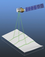
ICESat-2 (Ice, Cloud, and land Elevation Satellite 2), part of NASA's Earth Observing System, is a planned (year of writting: 2012) satellitemission for measuring ice sheet mass elevation, sea ice freeboard as well as land topography and vegetation characteristics. ICESat-2 is a planned follow-on to the ICESat mission. It will be launched in 2016 from Vandenberg Air Force Base in California into a near-circular, near-polar orbit with an altitude of approximately 496 km. It is being designed to operate for 3 years, and will carry enough propellant for 7 years.
The ICESat-2 mission is designed to provide elevation data needed to determine ice sheet mass balance as well as vegetation coverage information. It provides topography and vegetation data around the globe, in addition to the polar-specific coverage over the polar regions.
The ICESat-2 project is being managed by NASA Goddard Space Flight Center. The sole instrument is being designed and built by NASA Goddard Space Flight Center, and the bus is being provided by Orbital Sciences Corporation.
ICESat
ICESat (Ice, Cloud, and land Elevation Satellite), part of NASA's Earth Observing System, was a satellite mission for measuring ice sheet mass balance, cloud and aerosol heights, as well as land topography and vegetation characteristics.
ICESat was launched 13 January 2003 on a Delta II rocket from Vandenberg Air Force Base in California into a near-circular, near-polar orbit with an altitude of approximately 600 km.
It operated for seven years before being retired in February 2010, after its scientific payload shut down and scientists were unable to restart it.
The ICESat mission was designed to provide elevation data needed to determine ice sheet mass balance as well as cloud property information, especially for stratospheric clouds common over polar areas. It provides topography and vegetation data around the globe, in addition to the polar-specific coverage over the Greenland and Antarctic ice sheets. The satellite was found useful in assessing important forest characteristics, including tree density.