
Displaying items by tag: EPS
IT'S ALL ABOUT THE POWER
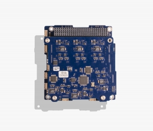
Designing satellites and space missions is complicated. There are all sorts of things to consider, like what are you trying to achieve, how many satellites do you need, what does your payload need to do, how much data do you need to get down, when do you need to downlink and what orbit will the satellites be in. And of course, you will need to power your satellite, ensuring that there is always enough power to run the satellite and its payload, run the on-board computers and operate the radios to download the data. Choosing the right Electrical Power System (EPS) for your satellites can be a complex and time-consuming exercise. But AAC Clyde Space can make it a lot easier to choose the right EPS solution.
EPS (EUMETSAT Polar System)
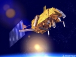
The EUMETSAT Polar System (EPS) is a European satellite system that offers remote sensing capabilities to both meteorologists and climatologists. It consists of a series of three polar orbiting Metop satellites, to be flown successively for more than 14 years, from 2006, together with the relevant ground facilities.
The satellites form the space segment component of the overall EPS system, which in turn is the European half of the EUMETSAT/NOAA Initial Joint Polar System (IJPS).
Metop-A (launched on 19 October 2006) and Metop-B (launched on 17 September 2012) are in a lower polar orbit, at an altitude of 817 kilometres, to provide more detailed observations of the global atmosphere, oceans and continents. The two satellites will operate in parallel for as long as Metop-A's available capacities bring benefits to users. Metop-C is due to be launched in 2017.
EPS Programme Background
EUMETSAT is responsible for coordinating all elements of the development, launch and operation of EPS satellites. This includes developing and procuring the ground segment; procuring the launcher and launch site, and operating the systems. Under the IJPS and Joint Transition Activities (JTA) agreement, EUMETSAT and NOAA have agreed to provide instruments for each other's satellites; exchange all data in real time, and assist each other with backup services. Other partners are European Space Agency and CNES.
The European and American satellites carry a set of identical sensors:
AVHRR/3 and the ATOVS suite consisting of AMSU-A, HIRS/4 and MHS. NOAA provides most of the joint instruments on board the satellites and EUMETSAT has developed and provides NOAA with the Microwave Humidity Sounder (MHS).
In addition, the Metop satellites carry a set of European sensors, IASI, ASCAT, GOME-2 and GRAS, aimed at improving atmospheric soundings, as well as measuring atmospheric ozone and near-surface wind vectors over the ocean. They also carry the Argos Advanced Data Collection System (A-DCS).
EPS-SG (programme)
EPS is a programme of Earth observation for Meteorology and weather forecast. The satellite is called METOP. EPS/METOP is managed by the European organisation EUMETSAT. Placed on a polar orbit, the satellite sends picture of the whole Earth.
EPS-SG is the Second Generation of this programme. (respectively the satellite is METOP-SG)
Activities are on-going (Aug. 2012) for the definition of the follow-on EUMETSAT Polar System, to replace the current satellite system in the 2020 timeframe and contribute to the Joint Polar System to be set up with NOAA. Through consultation with users and application experts, requirements have been defined for a range of candidate missions mainly in support of operational meteorology and climate monitoring. A number of on-board instruments, satellite platforms and ground support infrastructure are under study in coordination with ESA, NOAA, DLR and CNES. The satellites will fly, like Metop, in a sun synchronous, low earth orbit at 817 km altitude and 09:30 local time of the descending node, providing observations over the full globe with revisit times of 12 to 24 hours, depending on instrument. Feasibility studies are on-going with the main objective to define the baseline configuration for subsequent detailed design, development and operation programmes to be proposed and coordinated within the involved organisations. Started in 2005 under the name of Post-EPS, the activities will enter in 2012 the design and development phases under a new programme: EPS Second Generation (EPS-SG).
Metop
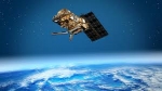
MetOp is a series of three polar orbiting meteorological satellites operated by EUMETSAT, the European Organisation for the Exploitation of Meteorological Satellites.
The satellites form the space segment component of the overall EUMETSAT Polar System (EPS), which in turn is the European half of the EUMETSAT/NOAA Initial Joint Polar System (IJPS). The satellites carry a payload comprising 11 scientific instruments and two which support Search and Rescue services. In order to provide data continuity between MetOp and NOAA Polar Operational Satellites (POES), several instruments are carried on both fleets of satellites.
EUMETSAT
The European Organisation for the Exploitation of Meteorological Satellites (EUMETSAT) is an intergovernmental organisation created through an international convention agreed by a current total of 30 European Member States.
EUMETSAT's primary objective is to establish, maintain and exploit European systems of operational meteorological satellites. EUMETSAT is responsible for the launch and operation of the satellites and for delivering satellite data to end-users as well as contributing to the operational monitoring of climate and the detection of global climate changes.
The activities of EUMETSAT contribute to a global meteorological satellite observing system coordinated with other space-faring nations.
Satellite observations are an essential input to numerical weather prediction systems and also assist the human forecaster in the diagnosis of potentially hazardous weather developments. Of growing importance is the capacity of weather satellites to gather long-term measurements from space in support of climate change studies.
EUMETSAT is not part of the European Union, but became a signatory to the International Charter on Space and Major Disasters in 2012, thus providing for the global charitable use of its space assets.[1]
- public organisation
- Europe
- mission operations
- satellite operator
- meteorology
- Copernicus (EO program)
- Meteosat Third Generation
- Meteosat
- Meteosat Second Generation
- MTG
- MSG
- MTP
- Meteosat Transition Phase
- METOP
- METOP SG
- Sentinel 1
- Sentinel 2 satellite
- Sentinel 2
- Sentinel 3
- Sentinel 4
- sentinel 5P
- sentinel 5
- Sentinel 6
- JasonCS
- Jason 2
- Jason 3
- EPS
- EPS_SG
- NOAA