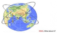
The Indian Regional Navigational Satellite System (IRNSS) is an autonomous regional satellite navigation system being developed by the Indian Space Research Organisation (ISRO).
The proposed system would consist of a constellation of seven satellites and a support ground segment. Three of the satellites in the constellation will be placed in geostationary orbit. These GEOs will be located at 34 East 83 East and 132 East longitude. Two of the GSOs will cross the equator at 55 East and two at 111 East. Such an arrangement would mean all seven satellites would have continuous radio visibility with Indian control stations. The satellite payloads would consist of atomic clocks and electronic equipment to generate the navigation signals.
This system will be under complete control of the Indian government. The requirement of such a navigation system is driven by the fact that access to Global Navigation Satellite Systems, GPS, is not guaranteed in hostile situations. The IRNSS would provide two services, with the Standard Positioning Service open for civilian use and the Restricted Service, encrypted one, for authorised users (military).


