Displaying items by tag: navigation system
European Global Navigation Satellite Systems Agency (GSA)

The GSA’s mission is to support European Union objectives and achieve the highest return on European GNSS investment, in terms of benefits to users and economic growth and competitiveness, by:
- Designing and enabling services that fully respond to user needs, while continuously improving the European GNSS services and Infrastructure;
- Managing the provision of quality services that ensure user satisfaction in the most cost-efficient manner;
- Engaging market stakeholders to develop innovative and effective applications, value-added services and user technology that promote the achievement of full European GNSS adoption;
- Ensuring that European GNSS services and operations are thoroughly secure, safe and accessible.
Mars GNSS FATIMA
The planetary science of recent days is very focused on our neighbor, planet Mars. Current navigation and positioning systems used by surface rovers or orbital systems are often complicated and their possible maintenance requires a huge effort of the ground control teams on Earth. Construction and design of these probes is expensive, due to necessary redundancy of their on-board systems, usually consisting of computers, sensors, navigation cameras and other intelligent technologies. Complexity of these current systems is making them very sensitive. Any small error in position calculation can result not only in wrong direction or in bad position determination, but can even endanger the whole mission. For example when such vehicle reaches some danger zone – like the edge of a crater, valley, or rocky area. Precise navigation and timing is one of the key factors of the next steps of Mars research. We are heading towards the next giant leap of Mankind, when the first humans will possibly land on a surface of Mars. Advanced robotic missions including flying robots, surface rovers, new orbital probes and possible future human mission, will need the one universal positioning system and one the universal time service. This can be resolved by proposed global navigation satellite system for Mars. We have used the name FATIMA as acronym for such system, which simply means Fix And TIme provisioning system for MArs. The constellation of FATIMA satellites orbiting Mars will provide real time positioning service, navigation service and timing service, for multiple users. This system will not be analogy to our Earth based GPS, Galileo or Glonass systems, but will be more complex and possibly maintained by the international control body on Earth. The system will be suitable also for the geodetic measurements and for the possible tectonic research of Mars. It will allow us to come personally beyond our own current human world. Author of the concept of the Mars GNSS FATIMA and of the research related to this is Dr. Jozef Kozar (http://www.sciencemars.com/kozar).
Elettronica Marittima S.r.l.

Radar Systems; Integrated Navigation systems; Sourveillance Systems;
IRNSS
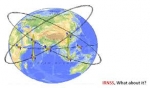
The Indian Regional Navigational Satellite System (IRNSS) is an autonomous regional satellite navigation system being developed by the Indian Space Research Organisation (ISRO).
The proposed system would consist of a constellation of seven satellites and a support ground segment. Three of the satellites in the constellation will be placed in geostationary orbit. These GEOs will be located at 34 East 83 East and 132 East longitude. Two of the GSOs will cross the equator at 55 East and two at 111 East. Such an arrangement would mean all seven satellites would have continuous radio visibility with Indian control stations. The satellite payloads would consist of atomic clocks and electronic equipment to generate the navigation signals.
This system will be under complete control of the Indian government. The requirement of such a navigation system is driven by the fact that access to Global Navigation Satellite Systems, GPS, is not guaranteed in hostile situations. The IRNSS would provide two services, with the Standard Positioning Service open for civilian use and the Restricted Service, encrypted one, for authorised users (military).