Displaying items by tag: Earth observation
LSTM Copernicus - Land Surface Temperature Monitoring mission
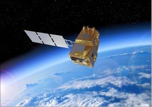
LSTM is a next generation ESA mission within the Copernicus program to complement Sentinel observation capabilities with high spatio-temporal resolution TIR (Thermal Infrared) observations over land and coastal regions in support of agriculture management services,and possibly a range of additional applications and services. The primary objective is to enable monitoring the evapotranspiration (ET) rate at European field scale by capturing the variability of Land Surface Temperature (LST) (and hence derived ET) allowing more robust estimates of field-scale water productivity.
TARANIS (Tool for the Analysis of RAdiations from lightNIngs and Sprites)
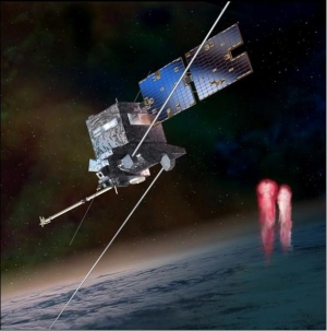
TARANIS is a CNES microsatellite mission, proposed by LPCE (Laboratoire de Physique et de Chimie de l'Environnement), and CEA (Commissariat a l'Energie Atomique) of France in collaboration with institutions from USA, Denmark, Japan, the Czech Republic and Poland. The TARANIS mission is devoted to the study of transient event energetic mechanisms that generate transient luminous emissions and gamma ray flashes in the terrestrial atmosphere above the thunderstorm areas. These emissions are a manifestation of a coupling between atmosphere, ionosphere and magnetosphere via intense transitory processes implying avalanching relativistic electrons with energies up to 30 MeV.
Note: In ancient mythology, TARANIS was the Gallic god of thunder and lightning.
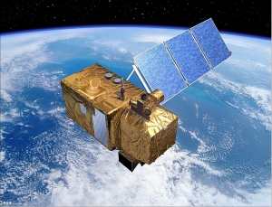
SEOSat - Ingenio - Earth Observation Satellite of Spain
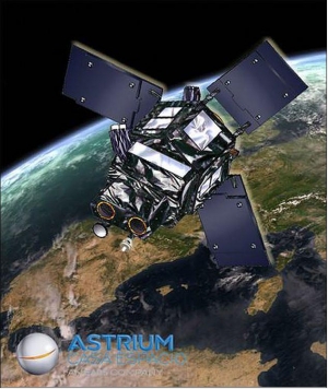
Ingenio, Spanish for “ingenuity”, is an optical high-resolution imaging mission of Spain - the flagship mission of the Spanish Space Strategic Plan 2007-2011. The mission is devoted to providing high resolution multispectral land optical images to different Spanish civil, institutional and government users, and potentially to other European users in the framework of Copernicus (formerly GMES) and GEOSS. The overall mission objective is to provide information for applications in cartography, land use, urban management, water management, environmental monitoring, risk management and security. The requirements call for panchromatic imagery of 2.5 m and multispectral imagery of 10 m resolution. 1) 2)
Copernicus: Sentinel-3 - Global Sea/Land Monitoring Mission including Altimetry
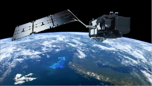
The Sentinel-3 (S3) mission of ESA and the EC is one of the elements of the GMES (Global Monitoring for Environment and Security) program, which responds to the requirements for operational and near-real-time monitoring of ocean, land and ice surfaces over a period of 20 years. The topography element of this mission will serve primarily the marine operational users but will also allow the monitoring of sea ice and land ice, as well as inland water surfaces, using novel observation techniques.The Sentinel-3 mission is designed as a constellation of two identical polar orbiting satellites, separated by 180º, for the provision of long-term operational marine and land monitoring services. The operational character of this mission implies a high level of availability of the data products and fast delivery time, which have been important design drivers for the mission. 1) 2) 3) 4) 5) 6) 7) 8) 9) 10) 11) 12) 13) 14)
The Sentinel-3 program represents a series of operational spacecraft over the envisioned service period to guarantee access to an uninterrupted flow of robust global data products.
Copernicus: Sentinel-2 - The Optical Imaging Mission for Land Services
Sentinel-2 is a multispectral operational imaging mission within the GMES (Global Monitoring for Environment and Security) program, jointly implemented by the EC (European Commission) and ESA (European Space Agency) for global land observation (data on vegetation, soil and water cover for land, inland waterways and coastal areas, and also provide atmospheric absorption and distortion data corrections) at high resolution with high revisit capability to provide enhanced continuity of data so far provided by SPOT-5 and Landsat-7. 1) 2) 3) 4) 5) 6) 7) 8)
Magnolia Terra LLC

Magnolia Terra LLC, Moscow, Russia, is a privately-owned company with a mission to provide cost effective quality Remote Sensing Imagery services and to contribute to the development of new technologies. The main goal of development of a wide range of Magnolia-family software products (Magnolia rsLab, Magnolia iMATH, Magnolia psDraw) is to provide solutions for virtually every stage of the satellite data acquisition and satellite data analysis processes.
A resident of the Skolkovo Innovation Centre, the Space Technology and Telecommunications Cluster. Reg. no. 1120388.
Specialties: Earth observation, remote sensing, satellite imagery, software development, geophysics, environmental science.
Magnolia Terra LLC

Magnolia Terra LLC, Moscow, Russia, is a privately-owned company with a mission to provide cost effective quality Remote Sensing Imagery services and to contribute to the development of new technologies. The main goal of development of a wide range of Magnolia-family software products (Magnolia rsLab, Magnolia iMATH, Magnolia psDraw) is to provide solutions for virtually every stage of the satellite data acquisition and satellite data analysis processes.
A resident of the Skolkovo Innovation Centre, the Space Technology Cluster. Reg. no. 1120388.
Specialties: Earth observation, remote sensing, satellite imagery, software development, geophysics, environmental science.
Flock 1 constellation (Dove satellites)
Flock 1 is a fleet of 28 small satellites. Its deployment began on 11 Feb 2014 from the International Space Station. It was at that date the largest single constellation of Earth-imaging satellites ever to launch into space.
Built and operated by Planet Labs of San Francisco, the Flock 1 small satellites are individually referred to as Doves.
The Dove satellites are part of a class of miniature satellites often called CubeSats. These small satellites will capture imagery of Earth for use in humanitarian, environmental and commercial applications. Data collected by the Flock 1 constellation will be universally accessible to anyone who wishes to use it.
Membrane Optical Imager for Real-Time Exploitation (MOIRE)
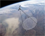
The Membrane Optical Imager for Real-Time Exploitation (MOIRE) program is a technology demonstration for the Defense Advanced Research Projects Agency (DARPA) that will provide persistent, real-time, tactical video to the war fighter. To accomplish this capability, MOIRE is incrementally demonstrating the technologies needed to develop a large lightweight space-based telescope for geosynchronous orbit using advanced diffractive membrane optics.
MOIRE plans to demonstrate the manufacturability of large collection area telescopes (up to 20 meters), large structures to hold the optics tight and flat, and also demonstrate the additional optical elements needed to turn a diffraction-based optic into a wide bandwidth imaging device.
While the membrane is less efficient than glass, which is nearly 90 percent efficient, its much lighter weight enables creating larger lenses that more than make up the difference. The membrane is also substantially lighter than glass. Based on the performance of the prototype, a new system incorporating MOIRE optics would come in at roughly one-seventh the weight of a traditional system of the same resolution and mass. As a proof of concept, the MOIRE prototype validates membrane optics as a viable technology for orbital telescopes.
With a proposed diameter of 20 meters, MOIRE's membrane optic "lens" would be the largest telescope optics ever made and dwarf the traditional glass mirrors used in the world's most famous telescopes.

Space telescope size comparison (click image to enlarge) - (copyright DARPA)
Perseus satellite constellation
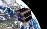
Perseus is a constellation of Earth observation satellite, based on the CubeSat platform.
Perseus will provide high quality imagery of the entire Earth, everyday, from a light CubeSat platform, offering imagery at an affordable price, making the data widely accessible. To bridge the data availability barrier, current and archived data will be available to all via a cloud based platform that encourages value added application development in addition to direct imagery access.
The Perseus constellation will utilize the CubeSat standard for cost-effective access to space as secondary payloads to larger, much more expensive Earth observing spacecraft. Traditional Sun-synchronous Earth observation orbits provide constant lighting conditions for data continuity through time. Synchronization of this constellation allows imagery of the entire Earth daily, which is something a traditional spacecraft would be incapable of doing, at a lower cost than one traditional spacecraft.