

 Image:
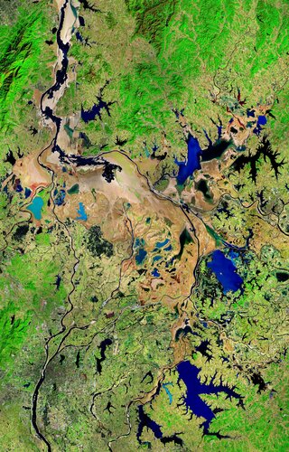
This Copernicus Sentinel-2 image shows Poyang Lake in China’s Jiangxi Province during winter.
Image:
This Copernicus Sentinel-2 image shows Poyang Lake in China’s Jiangxi Province during winter. This Copernicus Sentinel-2 image shows Poyang Lake in China’s Jiangxi Province during winter.
Zoom in to explore this image at its full resolution or click on the circles to learn more about the features in it.
In summer, Poyang Lake is China’s largest freshwater body, but in the dry season, it shrinks to less than a third of its former size. As clearly visible in this image captured on 31 January 2023, the receding waters leave behind a system of wetlands and mudflats, which are an important habitat for migratory waterfowl.
Poyang is one of China’s most important rice-producing areas, although local inhabitants must cope with massive seasonal changes in water level, topped by regular severe floods. Satellites have been used to monitor the evolution of the lake, as an improved understanding of Poyang Lake's annual dynamics could help with flood mitigation.
This false-colour image combines both infrared and visible light. This combination allows us to easily identify water bodies, distinguish crop types and differentiate vegetation conditions. As water absorbs infrared, shallow waters with a high concentration of sediments are shown in various shades of blue, while rivers appear in black.
The Gan River, visible in the bottom-left corner, flows northward into Poyang Lake through the city of Nanchang, capital of the Jiangxi Province.
Exposed dry soil in the lake’s basin appears in light brown. In contrast, agricultural areas and forests stand out in vibrant tones of green. In the lower part of the image, a dense system of canals feeds the cultivated fields, that can be identified as rectangular shapes nestled within the canals. Some of the fields appear in shades of blue, meaning they are waterlogged.