

 Utilities and local energy distribution companies (LDCs) face ongoing challenges in managing their infrastructure. Keeping track of power lines, pipelines, energy plant emissions, and other assets is essential to prevent power outages, wildfires, broken power lines, and methane leaks.
 Perrysburg OH (SPX) Nov 25, 2025
Utilities and local energy distribution companies (LDCs) face ongoing challenges in managing their infrastructure. Keeping track of power lines, pipelines, energy plant emissions, and other assets is essential to prevent power outages, wildfires, broken power lines, and methane leaks. Rather than waiting for the next disaster, LDCs are using satellites to deliver high-resolution imagery for AI-powered spatial analytics, offering a bird's-eye view to detect issues before they become disasters.
Satellite imagery is the best way for utilities to maintain comprehensive, ongoing visibility into their assets. Energy providers face issues with vegetation threats, methane emissions, construction encroachments, and unanticipated landscape changes, and it's impossible (and expensive) to roll ground crews for regular inspections. It's more efficient and cost-effective to use remote sensing, artificial intelligence, and geographic information systems (GIS) to monitor assets from 270 miles up. Processing satellite images enables LDCs to spot problems in hours, rather than days or weeks.
Thanks to high-resolution satellite images, cloud computing, and artificial intelligence (AI), utilities can now monitor thousands of square miles of infrastructure faster, cheaper, and with more precision than ever before.
Space-based Monitoring Is a Game Changer
Technological advances like AI and the explosive growth of commercial high-resolution satellites have put new imaging and analytical capabilities in the hands of utilities. Space imaging companies like Airbus, Vantor (formerly Maxar), and Planet Labs now operate their own constellations of low-orbiting satellites that can capture images of the Earth's surface in astonishing detail, down to 30 centimeters, about the size of a dinner plate.Remote sensing technology (RST) captures multispectral and hyperspectral data from the satellites, then sends the data to cloud computing systems. AI-powered algorithms then look for spectral signatures to detect surface activities such as new vegetation growth, new construction, trenching, soil grading, new access roads, and other changes that could indicate encroachment on utilities' rights-of-way or a risk to power cables and pipelines.
The combination of cloud computing and AI-powered data analysis can ingest enormous amounts of imaging data, enabling pixel-by-pixel and week-by-week comparisons. Using satellite images is more comprehensive and cost-effective than using aircraft or drone imaging, or sending a crew to inspect new building sites or a transmission corridor. Additionally, the system can be programmed to send a detailed alert when it detects a problem, such as a risk of falling trees or a methane leak.
Detecting Power Line Risks
Southern Company, a utility responsible for thousands of miles across Alabama, Georgia, Florida, and Mississippi, has been using satellite geospatial analytics for corridor encroachment monitoring.Southern Company owns the right-of-way for electrical transmission lines, although it does not own the property. The company must patrol these corridors to watch for issues, such as a landowner pouring a new slab for a structure or extending a parking lot into the right-of-way. Any encroachment could pose risks to power lines or create additional hazards in the event of a storm or heat wave.
These corridors are usually inspected every few years. Rolling crews or using aircraft to examine the corridors is expensive and far too slow to catch early-stage construction.
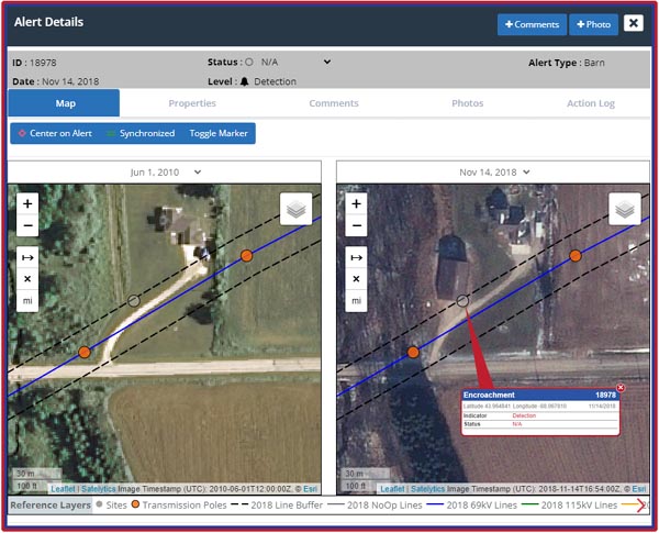
Using high-resolution satellite images, AI algorithms can detect anomalies right away. A change in the soil grade, new rooflines, or unauthorized digging could signal the start of a new structure. Spotting these activities early means Southern Company can intervene while the structure is still movable, saving tens of thousands of dollars and avoiding potential safety hazards.
Trees Can Tell a Story
One of the most common threats to the energy infrastructure is vegetation. Trees, bushes, and grasses must be cut back so they don't encroach on power lines. One fallen tree limb or grass fire can knock out power lines and threaten the electrical grid.Traditionally, utility companies would manually spot-check transmission corridors, extrapolating conditions for the area. High-resolution satellite imagery is more accurate, providing detailed images with a resolution as fine as 30cm, allowing identification of trees, limbs, and potential vegetation threats. The algorithm can identify types of trees and even measure tree height with an accuracy of within 5%. It can also reveal signs of stress, such as chlorosis or drought damage.
One utility company decided to use satellite imaging and AI technology to determine where to remove trees encroaching on power lines based on their height and health. The initial analysis in Fall 2022 detected 200,651 trees and vegetation clusters in the danger zone. The danger zones were then prioritized using a heat map.
Following the success of the initial satellite assessment, the utility conducted a second analysis in the Summer of 2023 to determine the most likely threats for the coming year. Spatial analysis offered a new level of granularity, identifying tree species and vegetation growth and health to predict future problem areas.
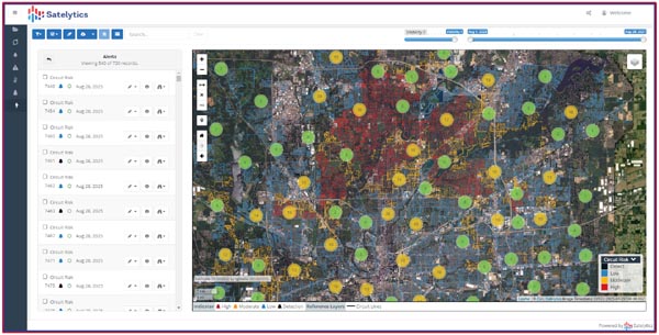
Preventing More than Two Calls a Day
For many utilities, responding to infrastructure damage is an ongoing effort. Everything from accidental excavations to downed power lines could trigger an incident requiring a crew to be rolled to fix the problem, sometimes more than once.Using satellite imagery and geospatial analytics, one utility has reduced incidents to just one or two per day. Satellite images allow the utility to keep a close eye on its infrastructure and analyze changes multiple times each week. That includes flagging new construction, equipment staging, geohazards, seasonal changes, and vegetation growth that could threaten service. An added benefit of using satellite images is that they can monitor hard-to-reach locations, such as remote powerlines, back yards, and areas outside the right-of-way.
Identifying problems using remote imaging saves time and resources. The cost of sending a crew can be $1,000 per truck roll or more; costs that have a direct impact on the bottom line. Using geospatial analytics, the utility can proactively address problems before they impact service.
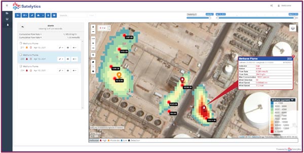
Detecting Invisible Gas Leaks
The Environmental Protection Agency's new "super emitter" rules put new pressure on oil and gas operators to detect and fix methane leaks quickly. Still, many leaks occur in remote areas that are difficult to monitor. Ground systems and sensor networks can't provide adequate coverage.Analyzing high-resolution shortwave infrared imagery available from only the best commercial satellite data providers, geospatial analytic techniques can detect methane leaks with flow rates as small as 1 kg/hr, with a resolution of 3.7 meters. This approach provides sufficient detail to pinpoint leaks within a few meters, making it easier to identify the source.
Monitoring operators can deliver methane alerts to utilities several times per month, allowing them to repair any leaks before third-party watchdogs or regulators can flag them.
About Sean Donegan:
Sean Donegan is CEO of Satelytics, a company that uses cloud-based, geospatial analytics to analyze multispectral and hyperspectral imagery to identify pipeline leaks and other environmental issues. Donegan has over 30 years of experience building technology and software companies.
Related Links
Satelytics
Earth Observation News - Suppiliers, Technology and Application