

 Image:
Return to the labyrinth
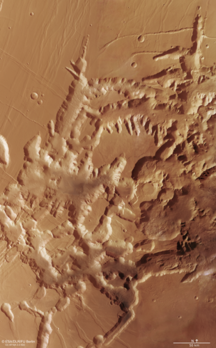
Image:
Return to the labyrinth Take another trip through Mars’s ‘labyrinth of night’ – a place unlike any other in the Solar System.
In October 2023, we featured a fly-over film of this part of Mars using data from ESA’s Mars Express. The same data – from the orbiter’s High Resolution Stereo Camera (HRSC) – has now been used to create this image. It’s large and detailed, and we’ve labelled a few key features. Be sure to zoom in, click around and explore deeply to be sure you don’t miss a thing!
Noctis Labyrinthus is a truly fascinating region. It’s filled with colossal landslides, vast windblown sand dunes, and dramatic intersecting canyons measuring up to 30 km wide and 6 km deep. The area spans around 1190 km in length – roughly the same as the tip to toe of Italy – and is found between the volcanic hub of Tharsis and the western edge of Mars’s ‘Grand Canyon’, Valles Marineris (a location shown more clearly in this associated context map).
While the original ground level can still be seen at the plateau-tops, large chunks of ground seem to have been haphazardly scooped away. This is due to past volcanism in the nearby region of Tharsis, which caused the crust to arch upwards, thin out, and fall away. There are also signs of hydrated salts and clay minerals in this labyrinth, indicating that water was once present here.
We have highlighted Mars Express views of Noctis Labyrinthus before in 2007 and 2016. The orbiter has circled the Red Planet since 2003, imaging Mars’s surface, mapping its minerals, studying its atmosphere, probing beneath its crust, and exploring how various phenomena interact in the martian environment. For more from the mission, see ESA's Mars Express releases.
Processing notes: The mosaic comprises data gathered over eight orbits (0442, 1085, 1944, 1977, 1988, 10497, 14632 and 16684) by ESA’s Mars Express and its HRSC. The ground resolution is approx. 12.5 m/pixel and the image is centred at about 265°E/7°S. North is up. For annotated and additional views of this mosaic, and a downloadable 'Digital Terrain Model’ of the region, see more resources provided by FU Berlin.
Download the data used to create this image here.
[Alt-text: The tan-coloured image shows a network of intersecting and irregularly shaped valleys and canyons, filling the frame and extending out of view. A number of features are highlighted, allowing the viewer to zoom and focus in on areas of note.]