

 Image:
The powerful Hurricane Otis has been captured in this Copernicus Sentinel-3 image when it was approaching Mexico’s southern Pacific coast in October 2023.
Image:
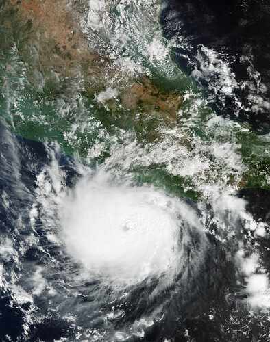
The powerful Hurricane Otis has been captured in this Copernicus Sentinel-3 image when it was approaching Mexico’s southern Pacific coast in October 2023. The powerful Hurricane Otis has been captured in this Copernicus Sentinel-3 image when it was approaching Mexico’s southern Pacific coast in October 2023.
Zoom in to explore this image at its full resolution or click on the circles to learn more.
Originally classified as a tropical storm, Otis was upgraded in just 12 hours to a category five hurricane – the most dangerous rating for a hurricane – shocking forecasters and local authorities alike. With sustained winds reaching around 265 km per hour, Hurricane Otis became the strongest on record to hit Mexico's Pacific coast. After making landfall near Acapulco, the hurricane began to weaken as it moved inland, leaving a trail of devastation.
This image, acquired on 24 October 2023 by Copernicus Sentinel-3’s Ocean and Land Colour Instrument, shows Hurricane Otis near Acapulco, where it made landfall the following day. The eye of the storm, which is very clear to see, had a diameter of approximately 25 km.
Acapulco, which is home to almost one million people is covered by storm clouds in the image. It was one of the worst places hit. Mexico City, the country’s huge, densely populated capital, can be seen as a brown area in the cloud-free part of the image north of the hurricane. The Popocatépetl active volcano can also be spotted about 70 km southeast of Mexico City.
To help emergency response efforts, both the International Charter Space and Major Disasters and the Copernicus Emergency Mapping Service were triggered to supply maps, based on satellite data, of the affected areas.
Hurricanes are one of the forces of nature that can be tracked by satellites. Timely imagery from space can help authorities take precautionary measures. Earth observation satellites are the best means of providing important information about storms, including size, wind speed and path, as well about features that contribute to the intensification of hurricanes, such as cloud thickness, temperature, and water and ice content.
Thanks to its daily revisits and spatial resolution, Copernicus Sentinel-3 is well equipped to measure, monitor and understand such large-scale global dynamics and provide essential information in near-real time for ocean and weather forecasting.