

 Image:
Like shining jewels in the water, ships passing through the Panama Canal, which cuts across Central America, have been captured in this Copernicus Sentinel-1 image.
Image:
Like shining jewels in the water, ships passing through the Panama Canal, which cuts across Central America, have been captured in this Copernicus Sentinel-1 image. Like shining jewels in the water, ships passing through the Panama Canal, which cuts across Central America, have been captured in this Copernicus Sentinel-1 image.
Zoom in to explore this image at its full resolution or click on the circles to learn more.
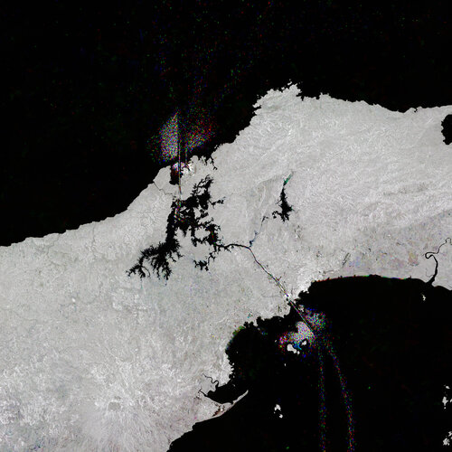
Connecting the Atlantic and Pacific Oceans, the 80 km-long Panama Canal is one of the greatest engineering projects of the last century.
Locks at either end are used to raise and lower the water level by as much as 26 metres: ships entering the canal are raised and then lowered to sea level as they exit. Under normal conditions, the canal sees up to 14,000 vessels pass every year, making it one of the busiest maritime passages in the world.
Copernicus Sentinel-1 satellites carry radar instruments to provide an all-weather, day-and-night supply of imagery of Earth’s surface, making it ideal to monitor ship traffic.
Here, hundreds of radar images acquired from 2020 to 2022 have been compressed into a single image. Separate colours have been assigned to each year to highlight differences: blue for images from 2020, green for 2021 and red for 2022. At either end of the canal, ships that are entering, exiting and waiting to pass through the waterway appear as dots of red, green and blue depending on the year.
While the trace of marine traffic is clear to see in channel, so too is traffic in Lake Gatun – the large, black jagged inland water body in the centre of the image.
Lake Gatun was created by damming the Chagres River to the north, where the river, which flows into the Caribbean Sea, can be seen as a black winding line. Water from the lake helps to keep the locks operational. However, this year Panama has been experiencing one of its driest seasons on record, significantly affecting the supply of freshwater needed to fill the locks.
In the last few months, this severe drought has forced the Panama Canal authority to gradually reduce the number of ships entering the canal from a 37 daily average to a maximum of 31 per day, which has impacted maritime traffic and the local and global economy.