

 Image:
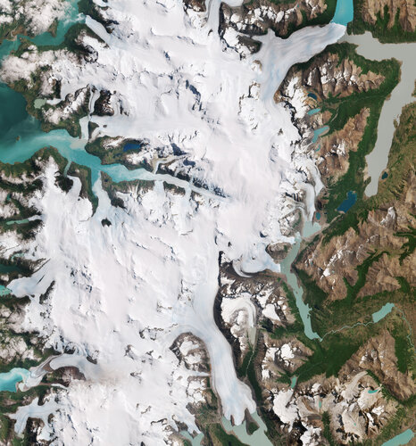
Part of the Southern Patagonian Ice Field with its white glaciers and aquamarine lakes is featured in this Copernicus Sentinel-2 image from 10 January 2023.
Image:
Part of the Southern Patagonian Ice Field with its white glaciers and aquamarine lakes is featured in this Copernicus Sentinel-2 image from 10 January 2023. Part of the Southern Patagonian Ice Field with its white glaciers and aquamarine lakes is featured in this Copernicus Sentinel-2 image from 10 January 2023.
Zoom in to explore this image at its full 10 m resolution or click on the circles to learn more.
Straddling the border of Chile and Argentina, the ice field stretches across the Patagonian Andes for more than 350 km and is one of the largest ice masses on Earth outside the polar regions.
Ice fields form as a result of accumulations of snow that turn into ice through years of compression and freezing. Shaped by the underlying topography, glaciers often form at the edges of an ice field.
In this image, the ice mass feeds several smaller and bigger glaciers, including the Argentinian Perito Moreno Glacier in the top right corner. Located on a narrow channel, Perito Moreno feeds Lake Argentino and forms an ice dam that separates the main body of the lake, visible on top in turquoise, from its southern arm, which appears grey.
Many lakes in the area are fed by waters from melting glaciers. The colour of the water varies from deep blue to grey depending on the amount of suspended fine sediment present. This sediment is called ‘glacier milk’ and is a result of abrasion as glaciers flow over the underlying rock.
The biggest glacier visible at the bottom of the image is the Grey Glacier, its terminus is split in three by pieces of land. It lies within the Torres del Paine National Park, one of the largest in Chile. The name of the park comes from the three distinctive granite peaks ‘Torres del Paine’, visible in the bottom right corner of the image.
The darker lines following the flow of most of the glaciers are moraines: accumulations of rock, soil and other debris that have been deposited by the glacier. Taking a closer look at the terminus of some of the glaciers, we can see how icebergs have broken off and are now floating in fjords and lakes.
Glaciers are the largest reservoirs of freshwater on our planet. The rate at which they may be melting or growing is one of the best indicators of climate change. The demise of glaciers is one of the main causes of sea-level rise. Many glaciers in Patagonia have retreated over the last 50 years. Satellite data can help monitor changes in glacier mass, extent and thickness and, subsequently, their contribution to rising sea levels.