

 Image:
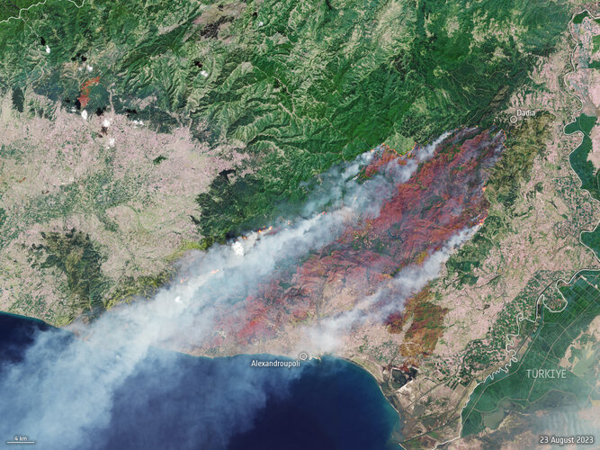
A month after fires ravaged the island of Rhodes in July 2023, more fires have ripped through Greece this week as southern Europe swelters under a late summer heatwave. This Copernicus Sentinel-2 image shows the ongoing blaze near Alexandroupoli in the Evros region of northeast Greece – close
Image:
A month after fires ravaged the island of Rhodes in July 2023, more fires have ripped through Greece this week as southern Europe swelters under a late summer heatwave. This Copernicus Sentinel-2 image shows the ongoing blaze near Alexandroupoli in the Evros region of northeast Greece – close A month after fires ravaged the island of Rhodes in July 2023, more fires have ripped through Greece this week as southern Europe swelters under a late summer heatwave. This Copernicus Sentinel-2 image shows the ongoing blaze near Alexandroupoli in the Evros region of northeast Greece – close to the Türkiye border.
Hot, dry and windy conditions have seen dozens of wildfires break out across Greece, with the most severe entering its fourth day and encroaching on the northeast port city of Alexandroupoli.
This satellite image is a blend between a natural colour and a shortwave infrared composite to highlight the fire front, which was approximately 70 km long when this image was captured on 23 August. The fire has produced a plume of smoke that stretched 1600 km southwest towards Tunisia. Burned area can be seen in the image in dark brown.
The Copernicus Sentinel-2 mission is based on a constellation of two identical satellites, each carrying an innovative wide swath high-resolution multispectral imager with 13 spectral bands for monitoring changes in Earth’s land and vegetation.
In response to the fires, the Copernicus Emergency Mapping Service has been activated in North Attica, Rodopi, Euboea Island, the Sterea Ellada Region, and East Macedonia. The service uses satellite observations to help civil protection authorities and, in cases of disaster, the international humanitarian community, respond to emergencies.
Climate change and land-use change are projected to make wildfires more frequent and intense. In light of the devastating wildfires, ESA has reopened its World Fire Atlas which provides a detailed analysis of wildfires taking place across the globe.