

 Image:
Rotterdam and part of the Zeeland province in southwest Netherlands are featured in this radar image acquired by Copernicus Sentinel-1.
Image:
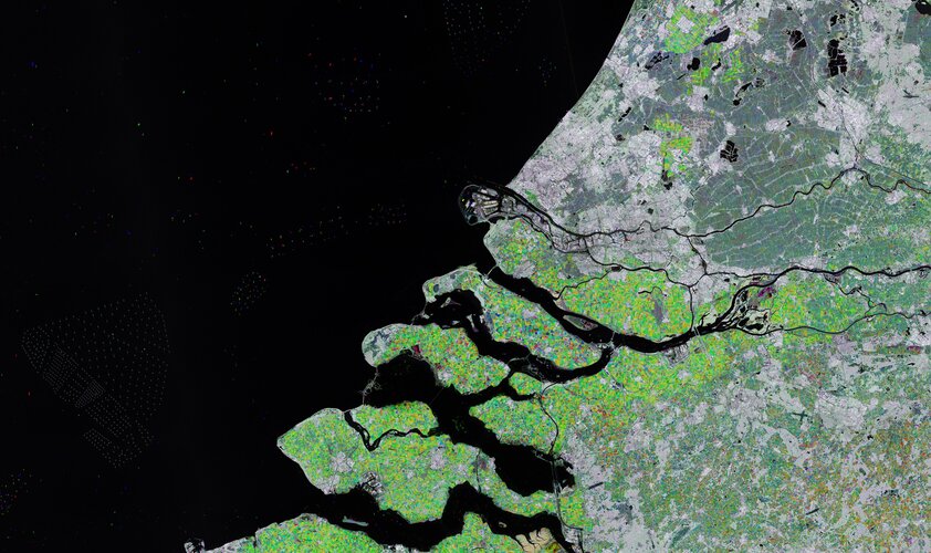
Rotterdam and part of the Zeeland province in southwest Netherlands are featured in this radar image acquired by Copernicus Sentinel-1. Rotterdam and part of the Zeeland province in southwest Netherlands are featured in this radar image acquired by Copernicus Sentinel-1.
Zoom in to explore this image at its full resolution or click on the circles to learn more.
This multitemporal picture is a combination of three radar images, each assigned to a colour channel: red for the image acquired in August 2022, green for the second image taken in January 2023, and blue for the last image from June 2023.
The combined images, with their different colours, help identify changes that have occurred between the acquisitions. For example, the green means that the vegetation was particularly lush when the January image was acquired.
Parts that appear grey or white depict little or no change. Water surfaces usually appear dark or black.
The coloured dots in the black of the North Sea are ships. Their colours indicate when they were captured by the satellite, as noted above. The white dots on the left are offshore wind farms.
Rotterdam, the country’s second largest city after Amsterdam, can be seen as a grey area near the centre of the image, straddling the New Meuse River, visible as a black line. Rotterdam is Europe’s largest port and the gateway to some 450 million customers.
Other cities pictured include Utrecht northwest of Rotterdam and The Hague northeast of Rotterdam. Moving north along the coast lies the town of Noordwijk, which is home to ESTEC, ESA’s technical centre, where new missions are designed, their industrial development is managed and, in some cases, the spacecraft and instruments are tested.
The large body of water south of Rotterdam is Haringvliet. Haringvliet dam is visible as a white and green bridge closing the mouth of the river. The dam was constructed as part of the ‘Delta Plan’ – a number of dams, sluices, dikes and barriers to reinforce the coastline. Volkerak dam, also part of the plan, is visible in the image at the eastern end of Haringvliet.
The area featured at the bottom of the image is part of the province of Zeeland. It lies on a large river delta, formed by the confluence of the Schelde and Meuse rivers and consists of a complex system of islands, peninsulas and waterways, mostly below sea level and interconnected by the dams and bridges of the Delta Works.