

 Image:
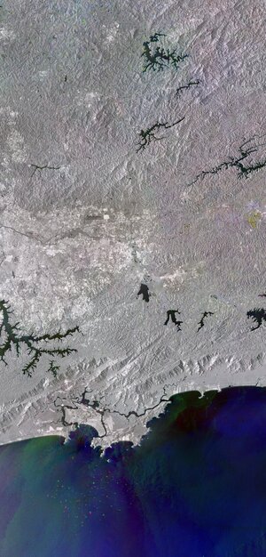
This radar image from Copernicus Sentinel-1 shows the city of São Paulo and part of the homonymous state in southeast Brazil.
Image:
This radar image from Copernicus Sentinel-1 shows the city of São Paulo and part of the homonymous state in southeast Brazil. This radar image from Copernicus Sentinel-1 shows the city of São Paulo and part of the homonymous state in southeast Brazil.
Zoom in to explore this image at its full resolution or click on the circles to learn more.
While standard radar images are usually black and white, this composite image combines three separate radar acquisitions, each assigned to a specific colour, so that the resulting colours show changes in land and water occurred between acquisitions. Areas in grey depict little or no change.
The first image, captured on 1 December 2022, is assigned to the blue channel; the second, from 6 January 2023, to green; and the third, from 11 February 2023, to red.
Radar data are interpreted by studying the intensity of the backscattered radar signal.
Water surfaces reflect the radar signal away from the satellite which makes water bodies appear dark, such as the Billings reservoir visible near the southern outskirts of the city.
In certain water bodies, such as the Represa do Jaguari reservoir at the top of the image, the shores have different coloured outlines owing to the changing level of the water.
Urban areas appear white as cities reflect radar extremely well. The brightest areas in the image represent the most densely built.
São Paulo, the capital of São Paulo state, is visible as the large, bright area in the centre-left of the image. This huge sprawling metropolis has an area of nearly 1500 sq km and a population of over 10 million, making it the most populous city in South America.
São Paulo is situated on a plateau extending behind the Serra do Mar mountain range, which can be seen running along the Atlantic coast. São Paulo’s port, Santos, lies 50 km southeast of the city on the São Vicente Island, separated from the mainland by a tidal channel.
Ships heading to or leaving the port of Santos appear as shining, coloured dots off the coast. Their colours depend on the date the images were acquired. Changes in the water, caused by surface currents and waves, can be seen as different shades in the Atlantic Ocean.