

 Image:
Deadly wildfires continue to rage in south-central Chile destroying hundreds of thousands of hectares of land across the country. Satellite images captured by the Copernicus Sentinel-3 mission on 4 February show the ongoing fires and heatwave in South America.
Image:
Deadly wildfires continue to rage in south-central Chile destroying hundreds of thousands of hectares of land across the country. Satellite images captured by the Copernicus Sentinel-3 mission on 4 February show the ongoing fires and heatwave in South America. Deadly wildfires continue to rage in south-central Chile destroying hundreds of thousands of hectares of land across the country. Satellite images captured by the Copernicus Sentinel-3 mission on 4 February show the ongoing fires and heatwave in South America.
The fires in Chile have consumed approximately 270 000 hectares of land, killing over 20 and injuring more than 1000 people. The government has declared a state of emergency in the Biobío, Ñuble and Araucania regions and is seeking international assistance to battle the fires from neighbouring countries.
The optical image on the left is a combination of images from the Ocean and Land Colour Instrument (OCLI) and Sea and Land Surface Temperature Radiometer (SLSTR) onboard the Sentinel-3 satellite. This allows us to highlight the fire hotspots visible in shades of orange and red in the image.
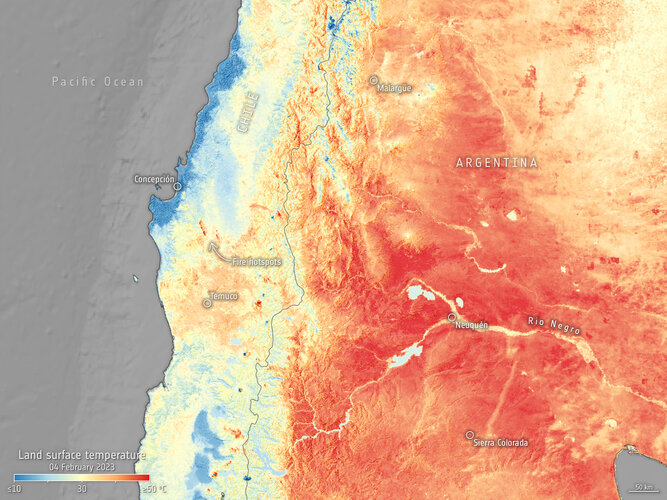
The map on the right, generated using data from Sentinel-3’s SLSTR instrument, shows the temperature of the land surface. The data show that ground temperatures in Neuquén reached 49°C, Sierra Colorada reached 45°C and Malargüe 38°C.
While weather forecasts use predicted air temperatures, this satellite instrument measures the real amount of energy radiating from Earth. Therefore, the map shows the actual temperature of the land’s surface pictured here on 4 February (11:00 local time), which is usually significantly hotter than air temperatures reported.
Chile is suffering through a decade-long period of dry weather. The searing heatwave and strong winds have caused the flames to spread and has complicated efforts to extinguish the flames, with air temperatures exceeding 40°C in some of the most affected areas. According to the Global Drought Observatory report, the current drought event in the Parana-La Plata Basin is the worst since 1944.
The blazes impact air quality as they release large quantities of aerosol into the atmosphere. The Copernicus Atmosphere Service reported forecasts of particulate matter 2.5 levels in the atmosphere up until 8 February.
In response to the wildfires, the Copernicus Emergency Mapping Service has been activated. Chile had requested support from the Member and Participating States to help limit the consequences of the destructive fires. The service uses observations from multiple satellites to provide on-demand mapping to help civil protection authorities and the international humanitarian community in the face of major emergencies.