

Copernical Team
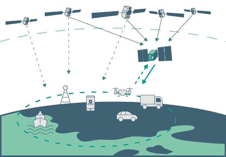
GEODNET offers centimeter precision and GNSS corrections for OEMS and Ag Sector
Researchers focus AI on finding exoplanets
 New research from the University of Georgia reveals that artificial intelligence can be used to find planets outside of our solar system. The recent study demonstrated that machine learning can be used to find exoplanets, information that could reshape how scientists detect and identify new planets very far from Earth.
"One of the novel things about this is analyzing environments where pla
New research from the University of Georgia reveals that artificial intelligence can be used to find planets outside of our solar system. The recent study demonstrated that machine learning can be used to find exoplanets, information that could reshape how scientists detect and identify new planets very far from Earth.
"One of the novel things about this is analyzing environments where pla SwRI models explain canyons on Pluto moon
 In 2015, when NASA's New Horizons spacecraft encountered the Pluto-Charon system, the Southwest Research Institute-led science team discovered interesting, geologically active objects instead of the inert icy orbs previously envisioned. An SwRI scientist has revisited the data to explore the source of cryovolcanic flows and an obvious belt of fractures on Pluto's large moon Charon. These new mod
 Fundamentals of Space Missions
 The newly released book "Fundamentals of Space Missions: Problems with Solutions" (ISBN 9798985668742) provides a comprehensive guide for students, instructors, and professionals alike in the field of space systems and missions.
Written by Professor Mike Gruntman, a renowned astronautics expert who has taught the subject at the University of Southern California for the past 25 years to ove
The newly released book "Fundamentals of Space Missions: Problems with Solutions" (ISBN 9798985668742) provides a comprehensive guide for students, instructors, and professionals alike in the field of space systems and missions.
Written by Professor Mike Gruntman, a renowned astronautics expert who has taught the subject at the University of Southern California for the past 25 years to ove A circular economy to tackle space junk
. DOI: 10.1016/j.wasman.2022.10.024")
Southampton researchers have developed the world's first robust method for estimating the value and mass of space junk.
A fully circular economy for space—removing space junk and reusing or recycling it—is a viable possibility to safeguard the future for satellites and space exploration, according to new research from the University of Southampton.
The research estimates there is billions, potentially trillions, of dollars' worth of recyclable materials, in the form of space junk (mission debris and defunct satellites), orbiting the Earth. Knowing what is 'out there' will enable viable solutions to the growing problem to be effectively and justifiably pursued.
Space junk is a form of pollution that poses a threat to future space exploration and satellites—which we rely heavily on here on Earth.
As of January 2021, the US Space Surveillance Network reported 21,901 artificial objects in orbit around Earth, including almost 4,500 functioning satellites. But these are just the objects large enough to be tracked. There is also estimated to be more than 128 million pieces of debris smaller than 1cm, more than 900,000 pieces measuring 1cm to 10cm, and 34,000 pieces larger than 10cm.
Europe’s next radar satellite tip-top for flight
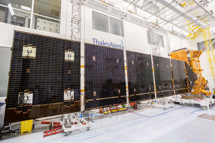
Following its arrival at Thales Alenia Space’s cleanroom facilities in the south of France last October, Europe’s next radar satellite, Copernicus Sentinel-1C, has been put through its paces in a series of tests and demonstrated that it is in tip-top condition for flight. Engineers have also carried out the all-important and precise check to ensure that the satellite fits on the adapter that connects it to the rocket that will take it into orbit.
Artemis II main engine
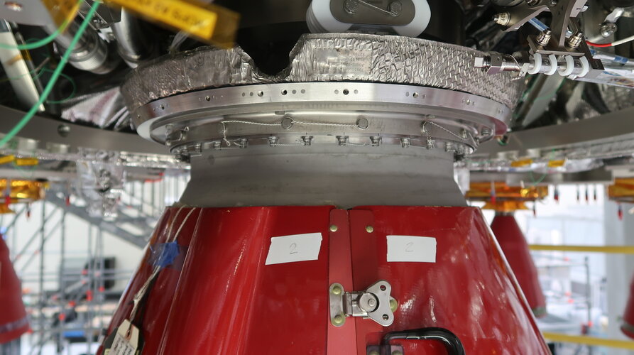 Image:
Artemis II main engine
Image:
Artemis II main engine Artemis II: main engine nozzle install
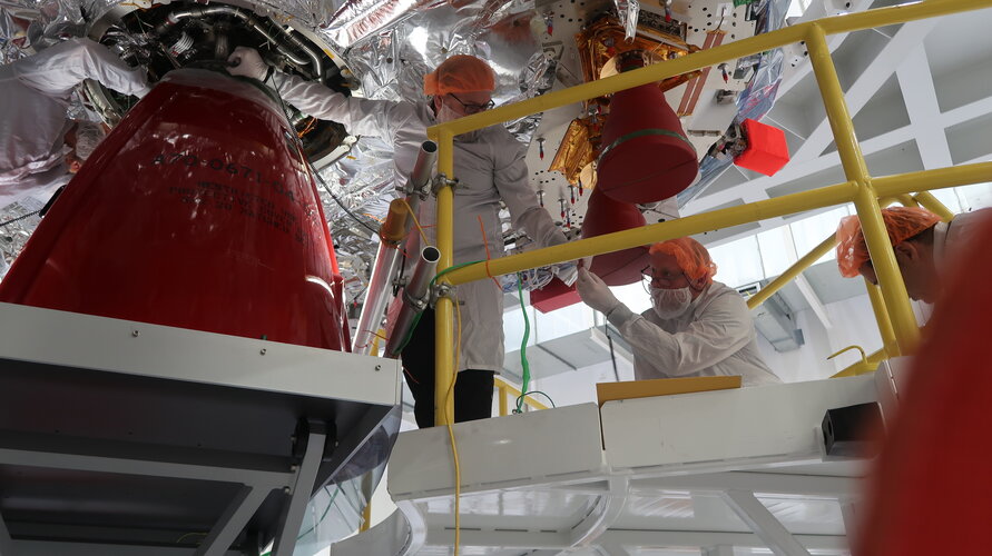 Image:
Artemis II: main engine nozzle install
Image:
Artemis II: main engine nozzle install Chile battles raging wildfires
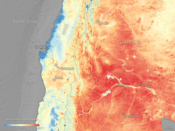 Image:
Deadly wildfires continue to rage in south-central Chile destroying hundreds of thousands of hectares of land across the country. Satellite images captured by the Copernicus Sentinel-3 mission on 4 February show the ongoing fires and heatwave in South America.
Image:
Deadly wildfires continue to rage in south-central Chile destroying hundreds of thousands of hectares of land across the country. Satellite images captured by the Copernicus Sentinel-3 mission on 4 February show the ongoing fires and heatwave in South America. Industry Day: find out how to take part in low-orbit satnav testing
ESA is embarking on the in-orbit demonstration of a new satellite navigation constellation operating much closer to our planet, utilising novel frequencies and capabilities, so the Agency is looking for European companies interested in taking part. Attend ESA’s LEO-PNT Industry Day on 7 March at ESA’s ESTEC technical centre in the Netherlands to find out more.