

 Image:
Earth from Space: The Mekong Delta
Image:
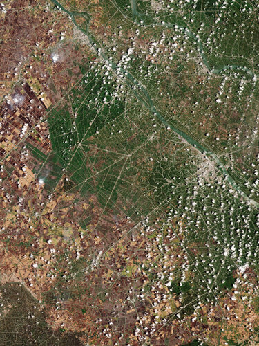
Earth from Space: The Mekong Delta The Copernicus Sentinel-2 mission captured a rare, almost cloud-free image over the Mekong Delta and the city of Can Tho in southwest Vietnam.
Zoom in to explore this image at its full 10 m resolution or click on the circles to learn more.
The Mekong Delta is a vast flood plain formed by the longest river in southeast Asia, the Mekong, which can be seen in the top right corner of the image. Its exceptionally fertile soil has established the area as one of the world’s richest agricultural regions.
The extensive patchwork of rice paddy fields can be seen across the image, intersected by an intricate web of irrigation and drainage canals. Vietnam is one of the world’s top rice producers and this region is often labelled Vietnam’s ‘rice bowl’.
Different colours in the fields could signify either different stages in plant growth or different agriculture methods being used for the crops. The various colours could also be the result of a common agricultural practice in the area: post-harvest, many fields are burned to clear and prepare for the next planting cycle. Recently burned fields appear black, while those where some time has passed since burning appear in shades of brown. Notably, wisps of smoke can be spotted, particularly in the left of the image, over some plots that were being burned at the time the image was captured.
There are very few roads in this area – the network of canals and waterways are used to transport people and products. All villages and cities in the area are therefore built along waterways.
The large river in the image, south of the Mekong, is the Hau River, a major branch of the lower Mekong River. On its left bank lies Can Tho, the largest city of the delta region and visible as a large grey area.
A large inland port, Can Tho is renowned for floating markets and for picturesque rural canals. Zooming in northwest of the city reveals the clear outline of the Can Tho International Airport.