


The Canary Islands are a group of ocean island volcanoes that were formed by volcanic activity millions of years ago. The Spanish region and archipelago is located around 100 km off the north coast of Africa and 1000 km from the Iberian Peninsula. The eight main islands are (in order of largest to smallest in area) Tenerife, Fuerteventura, Gran Canaria, Lanzarote, La Palma, La Gomera, El Hierro and La Graciosa. The archipelago also includes many smaller islands and islets.
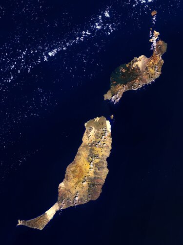
Lanzarote, the easternmost of the Canary Islands, is visible in the top-right of the image.
With over 150 000 inhabitants, it is the third most populous Canary Island, after Tenerife and Gran Canaria. It covers an area of 845 sq km, making it the fourth-largest of the islands in the archipelago.
Lanzarote has a long history of eruptions and is often referred to as the ‘Island of the 1000 volcanoes’, yet it is actually the least mountainous Canarian Island. The highest mountain is the volcano Peñas del Chache near Haría in the northern part of the island, which is 670 m above sea level. The Timanfaya National Park can be seen in the southwest part of the island and is entirely made up of volcanic soil.
Fuerteventura Island, the second largest of the Canaries, lies southwest of Lanzarote, across the Bocaina Strait. Its total area is 1731 sq km and the island is around 110 km long and no more than 30 km wide. Fuerteventura is the oldest island in the Canary Archipelago, having risen between 12 and 20 million years ago owing largely to volcanic activity.
The island is fairly flat and has a desert landscape of sand and stones as well as long beaches. The centre of the island is made up of a wide, elongated valley and, from north to south, is dissected by a series of extinct, eroded volcanoes. The west coast is dotted with rugged cliffs and small bays.
To the northeast of Fuerteventura, separated by the 15 m deep strait El Río, lies the island of Isla de Lobos. The only six sq km island is home to a 127 m high extinct volcano.
This image, also featured on the Earth from Space video programme, was captured on 24 September 2021 by Copernicus Sentinel-2 – a two-satellite mission to supply the coverage and data delivery needed for Europe’s Copernicus programme. The image was processed by selecting spectral bands that can be used for classifying geological features.