

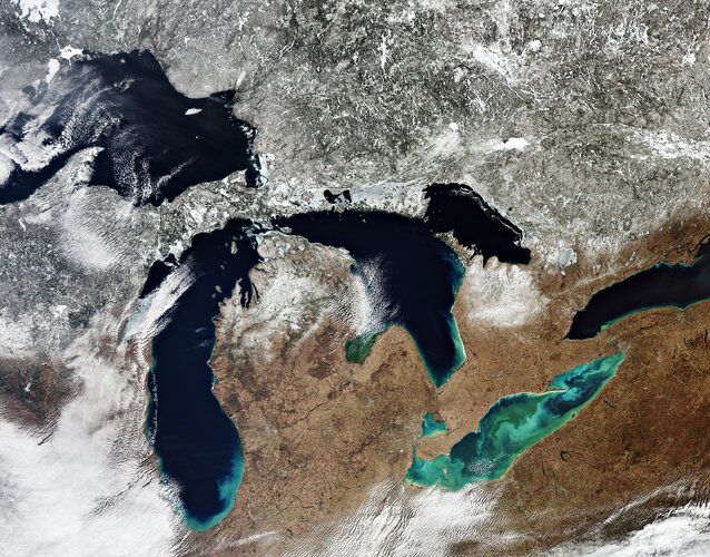

The Great Lakes are a chain of deep freshwater lakes. With a combined area of around 244 000 sq km, the lakes represent the largest surface of freshwater in the world – covering an area exceeding that of the United Kingdom.
Around 100 000 years ago, a major ice sheet formed over most of Canada and part of the US. As it formed, giant glaciers flowed into the land carving out valleys and levelling mountains. As higher temperatures began to melt the ice sheet, meltwater filled the holes left by the glaciers.
Many of these holes today still contain water and formed the thousands of lakes across central USA and Canada. The biggest remnants of this process are the Great Lakes. The lakes drain roughly from west to east and empty into the Atlantic Ocean.
Lake Superior, the northernmost and westernmost lake, is the largest and deepest of the Great Lakes. It drains into Lake Huron via the St. Marys River at an average rate of 2000 cubic metres per second. Lake Michigan lies south of Lake Superior and connects with Lake Huron through the six km-wide channel Straits of Mackinac in the north. Lake Huron is the second largest of the Great Lakes and is bounded by Michigan, US, on the north and by Ontario, Canada, to the east.
Lake Erie is the shallowest and southernmost of the Great Lakes. Green algal blooms are visible on the lake. These toxic blooms have been a problem for the lake in recent years. Caused by heightened levels of phosphorus – found in fertilisers and common household products – finding its way into the water, these blooms have caused harm to the lake’s fish population.
Lake Ontario is the easternmost of the Great Lakes and also the smallest in surface area. It is bounded on the north by Ontario, Canada and on the south by New York, US, whose water boundaries meet in the middle of the lake.
In this image, captured on 15 March 2020, a large quantity of ice and snow coverage is visible north of the lakes, yet the amount of ice cover on the lakes is minimal – extremely unusual for the ice season which typically runs from 1 December through 30 April.
Parts of the Great Lakes typically freeze every winter. As Earth’s climate changes, rising air and water temperatures have led to less ice cover on many lakes in North America, including the Great Lakes.