Displaying items by tag: satellite navigation
NAPEOS software

NAPEOS, the NAvigation Package for Earth Observation Satellites, is a state of the art software system for GNSS data processing providing results with a very accuracy.
NAPEOS is developed and maintained by the European Space Operations Centre (ESOC) of the European Space Agency (ESA). The NAPEOS developments started around 1995. In 2003 the GNSS capabilties started to be added a project that was finished in 2007. After significant testing the navigation support office at ESOC (OPS-GN) started to use the NAPEOS software in January 2008 for all its IGS activities.
A significant number of companies and individuals have been involved in the development of the NAPEOS software. Of course the major part of the GNSS work has been done at the navigation support office (OPS-GN) at ESOC with a special mentioning for the company GMV. GMV has been responsible for major parts of the actual programming of the NAPEOS source code.
At OPS-GN, in ESOC, NAPEOS supports all the activities in the International GNSS Service (IGS), the International DORIS Service (IDS), the International Laser Ranging Service (ILRS), and other international scientific communities. NAPEOS is also used for the routine precise orbit determination (POD) of several LEO missions, e.g., the ESA ENVISAT mission.
NAPEOS allows fully automated, robust, and reliable GNSS processing at very high accuracy levels with processing efficiency.
Commercial services using NAPEOS are proposed by the company PosiTim.
Multi-functional Satellite Augmentation System (MSAS)
Multi-functional Satellite Augmentation System (MSAS) is a Japanese SBAS (Satellite Based Augmentation System), i.e. a satellite navigation system which supports differential GPS (DGPS) designed to supplement the GPS system by reporting (then improving) on the reliability and accuracy of those signals.
A similar service is provided in North America by Wide Area Augmentation System (WAAS), and in Europe by European Geostationary Navigation Overlay Service (EGNOS).
It is operated by the Japan's Government.
Wide Area Augmentation System (WAAS)
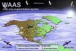
The Wide Area Augmentation System (WAAS) is an air navigation aid developed by the Federal Aviation Administration to augment the Global Positioning System (GPS).
The goal is to improve the GPS signal accuracy, integrity, and availability. Essentially, WAAS is intended to enable aircraft to rely on GPS for all phases of flight, including precision approaches to any airport within its coverage area.
WAAS uses a network of ground-based reference stations, in North America and Hawaii, to measure small variations in the GPS satellites' signals in the western hemisphere. Measurements from the reference stations are routed to master stations, which queue the received Deviation Correction and send the correction messages to geostationary WAAS satellites in a timely manner (every 5 seconds or better). Those satellites broadcast the correction messages back to Earth, where WAAS-enabled GPS receivers use the corrections while computing their positions to improve accuracy.
The International Civil Aviation Organization (ICAO) calls this type of system a satellite-based augmentation system (SBAS).
Similar service is provided in Asia, notably Japan, by the Multi-functional Satellite Augmentation System (MSAS), and in Europe by European Geostationary Navigation Overlay Service (EGNOS).
European GNSS Agency (GSA)

As an official European Union regulatory authority, the European GNSS Agency (GSA) manages public interests related to European GNSS(*) programmes.
The Agency's strategic objectives include the achievement of a fully operational GALILEO system. This includes the laying of foundations for a fully sustainable and economically viable system and its security.
(*) GNSS: Global Navigation Satellite Systems
EGNOS
The European Geostationary Navigation Overlay Service (EGNOS) is a satellite based augmentation system developed by the European Space Agency (ESA), the European Commission and EUROCONTROL.
The EGNOS system provides additional signals to users of satellite navigation services, broadcast through geostationary satellites, guaranteeing the integrity of satellite navigation so that it can be used in support of safety-of-life services such as civil aviation.
It supplements the GPS, GLONASS and Galileo systems by reporting on the reliability and accuracy of the positioning data. The official start of operations was announced by the European Commission on 1 October 2009.
According to specifications, horizontal position accuracy should be better than seven metres. In practice, the horizontal position accuracy is at the metre level. The EGNOS system consists of three geostationary satellites and a network of ground stations.
The system started its initial operations in July 2005, showing outstanding performances in terms of accuracy (better than two metres) and availability (above 99%); and it was certified for use in safety of life applications in March 2011. An EGNOS Data Access Service is also available since July 2012.
Similar service is provided in North America by the Wide Area Augmentation System (WAAS), and in Asia, notably Japan, by the Multi-functional Satellite Augmentation System (MSAS).
SGR-10 GPS Receiver
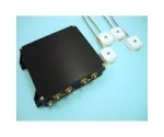
The Surrey Space GPS Receiver SGR-10 (2 antennae, 24 channels) is a single frequency, multiple antenna space GPS receiver designed as a spacecraft orbit determination subsystem for small satellite LEO applications.
The SGR-10 has two active patch antennas, and can be used for positioning only.
- Navigation for LEO missions
- 24 Channel L1 C/A Code Space GPS Receiver
- Fast start-up
- High visibility and redundancy
- Two active patch antennae included
- Price reflects batch build discount
- Delivery from batch build stock : 9 months
company: Surrey Satellite Technology
Beidou navigation system

The BeiDou Navigation System is a project of China to develop an independent satellite navigation system. It may refer to either one or both generations of the Chinese navigation system.
The first BeiDou system, officially called BeiDou Satellite Navigation Experimental System, or known as BeiDou-1, consists of three satellites and offers limited coverage and applications. It has been offering navigation services, mainly for customers in China and neighboring regions, since 2000.
The second generation of the system, known as Compass or BeiDou-2, which will be a global satellite navigation system consisting of 35 satellites, is still under construction as of May 2012. It became operational in China in December 2011, with 10 satellites in use. It is planned to offer services to customers in the Asia-Pacific region by 2012, and to global customers upon its completion in 2020.
The BeiDou Navigation System is sometimes named BDS.
Galileo Mission Segment (GMS)

The Galileo Mission Segment (GMS) will use a global network of nominally thirty Galileo Sensor Stations (GSS) to monitor the navigation signals of all satellites on a continuous basis.
It will use a comprehensive communications network using commercial satellites as well as cable connections in which each link will be duplicated for redundancy. The prime element of the GSS is the Reference Receiver. The GMS communicates with the Galileo satellites through a global network of Mission Up-Link Stations (ULS), installed at five sites, each of which will host a number of 3-metre antennas. ULSs will operate in the 5 GHz Radionavigation Satellite (Earth-to-space) band. The GMS will use the GSS network for the Orbitography Determination and Time Synchronisation (OD&TS) function, which will provide batch processing every ten minutes of all the observations of all satellites over an extended period and calculates the precise orbit and clock offset of each satellite, including a forecast of predicted variations (SISA - Signal-in-Space Accuracy) valid for the next hours. The results of these computations for each satellite will be up-loaded into that satellite nominally every 100 minutes using a scheduled contact via a Mission Up-link Station.
Galileo Navigation Program

Galileo is a joint initiative of the European Commission (EC) and the European Space Agency (ESA). Galileo will be Europe’s own global navigation satellite system, providing a highly accurate, guaranteed global positioning service under civilian control. It will be inter-operable with GPS and GLONASS, the two other GNSS (Global Navigation Satellite Systems). The complete system consists of:
• A space segment of 30 MEO satellites in 3 planes inclined at 56º
• A launch segment to place the satellites into their operational orbits
• A control ground segment for monitoring and control of the satellites
• A mission ground segment managing all mission specific data
• A user ground segment of equipment capable of receiving and using Galileo signals
Global Positioning System (GPS)
The Global Positioning System (GPS) is a space-based satellite navigation system that provideslocation and time information in all weather, anywhere on or near the Earth, where there is an unobstructed line of sight to four or more GPS satellites. It is maintained by the United Statesgovernment and is freely accessible by anyone with a GPS receiver with some technical limitations which are only removed for military users.
The GPS program provides critical capabilities to military, civil and commercial users around the world. It is an engine of economic growth and jobs, and has generated billions of dollars of economic activity. It maintains future warfighter advantage over opponents and is one of the four core military capabilities. In addition, GPS is the backbone for modernizing the global air traffic system.
The GPS project was developed in 1973 to overcome the limitations of previous navigation systems, integrating ideas from several predecessors, including a number of classified engineering design studies from the 1960s. GPS was created and realized by the U.S. Department of Defense (DoD) and was originally run with 24 satellites. It became fully operational in 1994.
Advances in technology and new demands on the existing system have now led to efforts to modernize the GPS system and implement the next generation of GPS III satellites and Next Generation Operational Control System (OCX). Announcements from the Vice President and the White House in 1998 initiated these changes. In 2000, U.S. Congress authorized the modernization effort, referred to as GPS III.
In addition to GPS, other systems are in use or under development. The Russian GLObal NAvigation Satellite System (GLONASS) was in use by only the Russian military, until it was made fully available to civilians in 2007. There are also the planned European Union Galileo positioning system, Chinese Compass navigation system, and Indian Regional Navigational Satellite System.