
Copernical Team
Death in space: Here's what would happen to our bodies

As space travel for recreational purposes is becoming a very real possibility, there could come a time when we are traveling to other planets for holidays, or perhaps even to live. Commercial space company Blue Origin has already started sending paying customers on sub-orbital flights. And Elon Musk hopes to start a base on Mars with his firm SpaceX.
This means we need to start thinking about what it will be like to live in space—but also what will happen if someone dies there.
After death here on Earth, the human body progresses through a number of stages of decomposition. These were described as early as 1247 in Song Ci's The Washing Away of Wrongs, essentially the first forensic science handbook.
First the blood stops flowing and begins to pool as a result of gravity, a process known as livor mortis. Then the body cools to algor mortis, and the muscles stiffen due to uncontrolled build-up of calcium in the muscle fibers. This is the state of rigor mortis.
Three hours to save Integral
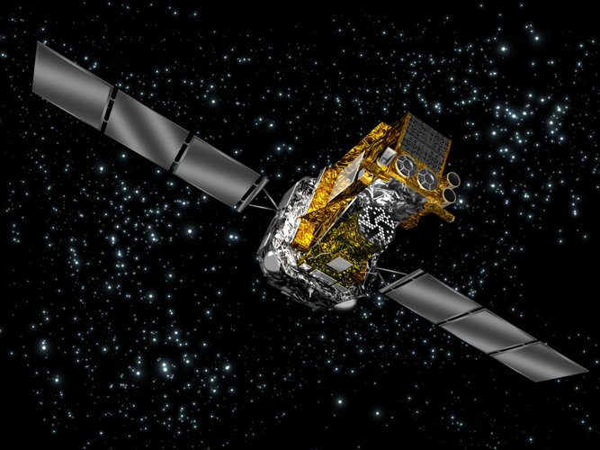
On 22 September, around midday, ESA’s Integral spacecraft went into emergency Safe Mode. One of the spacecraft’s three active ‘reaction wheels’ had turned off without warning and stopped spinning, causing a ripple effect that meant the satellite itself began to rotate.
How the Sun affects asteroids in our neighborhood

Asteroids embody the story of our solar system's beginning. Jupiter's Trojan asteroids, which orbit the Sun on the same path as the gas giant, are no exception. The Trojans are thought to be left over from the objects that eventually formed our planets, and studying them might offer clues about how the solar system came to be.
Over the next 12 years, NASA's Lucy mission will visit eight asteroids—including seven Trojans—to help answer big questions about planet formation and the origins of our solar system. It will take the spacecraft about three and a half years to reach its first destination. What might Lucy find?
Like all the planets, asteroids exist in the heliosphere, the vast bubble of space defined by the reaches of our Sun's wind. Directly and indirectly, the Sun affects many aspects of existence within this pocket of the universe. Here are a few of the ways the Sun influences asteroids like the Trojans in our solar system.
Place in Space
The Sun makes up 99.8% of the solar system's mass and exerts a strong gravitational force as a result.
Is Planetary Defense PI in the Sky?
 In February of 2013, skywatchers around the world turned their attention toward asteroid 2012 DA14, a cosmic rock about 150 feet (50 meters) in diameter that was going to fly closer to Earth than the spacecraft that bring us satellite TV.
Little did they realize as they prepared for the once-in-several-decades event that another bit of celestial debris was hurtling toward Earth, with a mor
In February of 2013, skywatchers around the world turned their attention toward asteroid 2012 DA14, a cosmic rock about 150 feet (50 meters) in diameter that was going to fly closer to Earth than the spacecraft that bring us satellite TV.
Little did they realize as they prepared for the once-in-several-decades event that another bit of celestial debris was hurtling toward Earth, with a mor Late-time small-body disruptions can protect the Earth
 If an asteroid is determined to be on an Earth-impacting trajectory, scientists typically want to stage a deflection, where the asteroid is gently nudged by a relatively small change in velocity, while keeping the bulk of the asteroid together.
A kinetic impactor or a standoff nuclear explosion can achieve a deflection. However, if the warning time is too short to stage a successful deflec
If an asteroid is determined to be on an Earth-impacting trajectory, scientists typically want to stage a deflection, where the asteroid is gently nudged by a relatively small change in velocity, while keeping the bulk of the asteroid together.
A kinetic impactor or a standoff nuclear explosion can achieve a deflection. However, if the warning time is too short to stage a successful deflec Study demonstrates Lunar composition mapping capabilities of SwRI-created space instrument
 A new study by a recent graduate of Southwest Research Institute's joint graduate program in physics with The University of Texas at San Antonio demonstrates the ability of the Lyman-Alpha Mapping Project (LAMP) to determine the composition of areas on the lunar surface by measuring the reflectance of far-ultraviolet (far-UV) light.
LAMP is an SwRI-created, far-UV spectrograph instrument a
A new study by a recent graduate of Southwest Research Institute's joint graduate program in physics with The University of Texas at San Antonio demonstrates the ability of the Lyman-Alpha Mapping Project (LAMP) to determine the composition of areas on the lunar surface by measuring the reflectance of far-ultraviolet (far-UV) light.
LAMP is an SwRI-created, far-UV spectrograph instrument a NASA launches Lucy probe to explore Jupiter asteroids
 NASA launched a spacecraft called Lucy on a 12-year mission to explore Jupiter's Trojan asteroids for the first time on Saturday, gathering new insights into the solar system's formation.
The Atlas V rocket responsible for propelling the probe took off at 5:34 am local time (0934 GMT) from Cape Canaveral.
Named after an ancient fossil of a pre-human ancestor, Lucy will become the first s
NASA launched a spacecraft called Lucy on a 12-year mission to explore Jupiter's Trojan asteroids for the first time on Saturday, gathering new insights into the solar system's formation.
The Atlas V rocket responsible for propelling the probe took off at 5:34 am local time (0934 GMT) from Cape Canaveral.
Named after an ancient fossil of a pre-human ancestor, Lucy will become the first s Dwarf planet Vesta a window to the early solar system
 The dwarf planet Vesta is helping scientists better understand the earliest era in the formation of our solar system. Two recent papers involving scientists from the University of California, Davis, use data from meteorites derived from Vesta to resolve the "missing mantle problem" and push back our knowledge of the solar system to just a couple of million years after it began to form. The paper
 Using the Moon to address digital inequality
 Most Americans take access to reliable, fast wireless internet (Wi-Fi) for granted. Yet, in underserved communities, reliable internet access can be as elusive as it is on the Moon. NASA is working to solve both challenges.
Digital inequality or inadequate internet access is a socioeconomic concern across the United States, and the pandemic has worsened the divide. In Cleveland, home of NA
Most Americans take access to reliable, fast wireless internet (Wi-Fi) for granted. Yet, in underserved communities, reliable internet access can be as elusive as it is on the Moon. NASA is working to solve both challenges.
Digital inequality or inadequate internet access is a socioeconomic concern across the United States, and the pandemic has worsened the divide. In Cleveland, home of NA Research to boost astronaut health for future space missions
 New research backed by the UK Space Agency will look to solve challenges such as muscle loss and isolation stress that astronauts face during long missions
The research, which uses the low gravity (microgravity) environment of the International Space Station and other facilities that provide similar conditions to space, could also potentially benefit people who suffer from conditions such
New research backed by the UK Space Agency will look to solve challenges such as muscle loss and isolation stress that astronauts face during long missions
The research, which uses the low gravity (microgravity) environment of the International Space Station and other facilities that provide similar conditions to space, could also potentially benefit people who suffer from conditions such 


