

Copernical Team
Just a Little Scoot: Sols 3814-3816
 We arrived this morning to Curiosity at a new location with some bright toned, and more rounded rocks in our vicinity. Unfortunately, we could look but not touch as our wheels were positioned such that we could not safely unstow the arm for contact science. We typically have a large suite of arm activities in weekend plans but with those now removed, the science team had ample power and time to
 Falcon Heavy launches massive GEO satellite for Viasat
 Elon Musk's SpaceX launched a Falcon Heavy rocket with a payload of satellites from the Kennedy Space Center on Sunday after having to abort the mission days earlier.
The two-stage rocket - loaded with competitor ViaSat-3 Americas broadband Internet satellite, as well as satellites by Astranis and Gravity Space - was scheduled to launch Friday evening but the mission was aborted with
Elon Musk's SpaceX launched a Falcon Heavy rocket with a payload of satellites from the Kennedy Space Center on Sunday after having to abort the mission days earlier.
The two-stage rocket - loaded with competitor ViaSat-3 Americas broadband Internet satellite, as well as satellites by Astranis and Gravity Space - was scheduled to launch Friday evening but the mission was aborted with Conservation groups sue US regulator over SpaceX launches
 US conservation groups on Monday announced they are suing the Federal Aviation Administration (FAA) for not doing enough to protect the environment from SpaceX's Starship program.
The move came after the world's most powerful rocket exploded on its first integrated test flight, just four minutes after launching from Boca Chica, Texas on April 20.
SpaceX video showed a hail of debris bein
US conservation groups on Monday announced they are suing the Federal Aviation Administration (FAA) for not doing enough to protect the environment from SpaceX's Starship program.
The move came after the world's most powerful rocket exploded on its first integrated test flight, just four minutes after launching from Boca Chica, Texas on April 20.
SpaceX video showed a hail of debris bein Zhurong Rover finds evidence of water at low latitudes on modern Mars
 The Zhurong rover has found evidence of water on dune surfaces on modern Mars by providing key observational proof of liquid water at low Martian latitudes, according to a study led by Prof. QIN Xiaoguang from the Institute of Geology and Geophysics (IGG) of the Chinese Academy of Sciences (CAS).
Researchers from the National Astronomical Observatories of CAS and the Institute of Atmospher
The Zhurong rover has found evidence of water on dune surfaces on modern Mars by providing key observational proof of liquid water at low Martian latitudes, according to a study led by Prof. QIN Xiaoguang from the Institute of Geology and Geophysics (IGG) of the Chinese Academy of Sciences (CAS).
Researchers from the National Astronomical Observatories of CAS and the Institute of Atmospher Massive radio array to search for ET signals from other civilizations
 One of the world's most powerful radio telescope arrays is joining the hunt for signals from other galactic civilizations. The National Science Foundation's Karl G. Jansky Very Large Array (VLA), situated about 50 miles west of Socorro, New Mexico, is collecting data that scientists will analyze for the type of emissions that only artificial transmitters make, signals that would betray the exist
 BlackSky releases rare satellite image of alleged airship in China
 BlackSky Technology Inc. (NYSE: BKSY) released the first and only known public satellite image, according to a third-party intelligence analyst, of an alleged aerostat at the Korla East Test Site, China. The rare image was captured Friday, November 4, 2022, at 9 a.m. local time and is one of only two images, from among more than 1,000 images collected over the duration of one year, that shows a
 Webb reveals early-Universe prequel to huge galaxy cluster
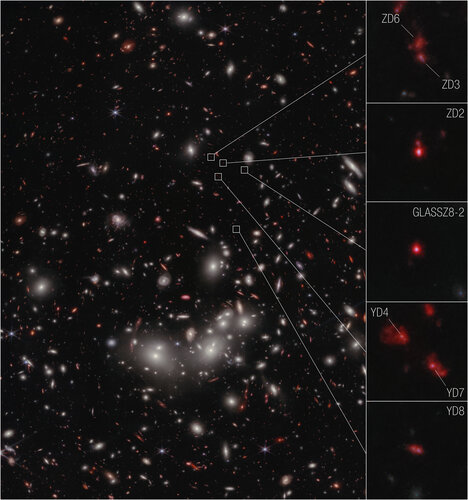 Image:
The seven galaxies highlighted in this image from the NASA/ESA/CSA Telescope have been confirmed to be at a distance that astronomers refer to as redshift 7.9, which correlates to 650 million years after the big bang. This makes them the earliest galaxies yet to be spectroscopically confirmed as part of a developing cluster.
The seven galaxies confirmed by Webb were first established as candidates for observation using data from the NASA/ESA Hubble Space Telescope’s Frontier Fields program. The program dedicated Hubble time to observations using gravitational lensing, to observe very distant galaxies in detail. However, because Hubble cannot detect light
Webb finds water vapor, but from a rocky planet or its star?
 Image:
Astronomers used the NASA/ESA/CSA James Webb Space Telescope to study a rocky exoplanet known as GJ 486 b. It is too close to its star to be within the habitable zone, with a surface temperature of about 430 degrees Celsius. And yet, their observations using Webb’s Near-Infrared Spectrograph (NIRSpec) show hints of water vapor. If the water vapor is associated with the planet, that would indicate that it has an atmosphere despite its scorching temperature and close proximity to its star. Water vapor has been seen on gaseous exoplanets before, but to date no atmosphere has been
JWST's MIRI instrument is having problems again
. Credit: NASA/Goddard Space Flight Center/Chris Gunn")
Last week, NASA shared a blog post saying they detected a sensor glitch associated with the James Webb Space Telescope's Mid-Infrared Instrument (MIRI). For some reason, the sensor for MIRI's Medium Resolution Spectroscopy (MRS) is receiving less light than expected at the longest wavelengths.
NASA is investigating the cause, and said that the instrument is not at risk and no effect has been seen for images taken by MIRI. According to agency officials, all other modes of JWST and MIRI remain unaffected, and they are searching for the underlying issue.
The glitch was found this month during regular calibration and monitoring of the telescope's performance.
SpaceX Starship effectively grounded by FAA after in-flight explosion

It was an exciting time when, two weeks ago, SpaceX got the clearance it needed to conduct its first orbital flight test with the Starship and Super Heavy launch system. After years of waiting, SN flight tests, static fire tests, and stacking and unstacking, the long-awaited test of the SN24 Starship and BN7 Booster prototype was on. For this flight, SpaceX hoped to achieve an altitude of at least 150 km (90 mi) above sea level, crossing the 100 km (62 mi) threshold that officially marks the boundary of "space" (aka. the Karman Line) and making a partial transit around the world before splashing down off the coast of Hawaii.
Unfortunately, things began to go awry a few minutes into the flight as the Starship prototype failed to separate from the booster, sending the rocket into a spin that ended in an explosion.