Displaying items by tag: Meteosat
Copernicus: Sentinel-4 - GEO Component Mission
The Sentinel-4 (S-4) mission within the context of Copernicus represents the geostationary component of European (EC, ESA) operational atmospheric composition monitoring missions.
In December 2007, the GMES Atmospheric Service Implementation Group of the EC (European Commission), issued its preliminary recommendations for the development of the GMES Space Segment operational capabilities in regard of atmospheric missions. In particular, it recommended implementing the Sentinel-4 mission as a UVN (UV/Visible/Near-infrared) sounder to be deployed on the two MTG Sounding (MTG-S) satellites. 1) 2) 3) 4) 5) 6)
|
Copernicus is the new name of the European Commission's Earth Observation Programme, previously known as GMES (Global Monitoring for Environment and Security). The new name was announced on December 11, 2012, by EC (European Commission) Vice-President Antonio Tajani during the Competitiveness Council. In the words of Antonio Tajani: "By changing the name from GMES to Copernicus, we are paying homage to a great European scientist and observer: Nicolaus Copernicus (1473-1543). As he was the catalyst in the 16th century to better understand our world, so the European Earth Observation Programme gives us a thorough understanding of our changing planet, enabling concrete actions to improve the quality of life of the citizens. Copernicus has now reached maturity as a programme and all its services will enter soon into the operational phase. Thanks to greater data availability user take-up will increase, thus contributing to that growth that we so dearly need today." |
Table 1: Copernicus is the new name of the former GMES program 7)
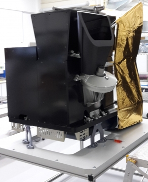
MTG - Meteosat Third Generation
MTG, Meteosat Third Generation, is a serie of geostationary meteorological satellites that will be procured and operated by the organisation EUMETSAT.
Considering the long development cycle for a new observational space system, EUMETSAT has been working on the definition and the planning for a Meteosat Third Generation (MTG) system since the year 2000, as a continuation of the Meteosat (1st generation) and MSG (2nd generation) missions.
The Meteosat Third Generation series will comprise six satellites, with the first spacecraft likely to be ready for launch from 2018. The in orbit configuration will consist of two parallel positioned satellites, the MTG-I imager (a 3-tonne satellite with 16 nominal channels) and the MTG-S sounder. The sounder will be one of the key innovations in the new programme, allowing Meteosat satellites, for the first time, to not just image weather systems but to analyse the atmosphere layer-by-layer and perform far more detailed chemical composition studies.
Unlike the first and second generation Meteosat series, MTG will be based on three axes stabilised platforms, meaning the instruments will be pointed at the Earth for 100% of their in orbit time. Such improvements are necessary to achieve compliance with more demanding user requirements on spatial resolution; repeat cycle and signal to noise ratio, and are a prerequisite to conduct soundings from geostationary orbit.
MTG components providing continuity of MSG services need to be available around 2015, before the end of the nominal lifetime of MSG. MTG preparatory activities started end of 2000 in cooperation with the European Space Agency (ESA), following the decision of the EUMETSAT Council to proceed with a Post-MSG User Consultation Process. The process is aimed at capturing the foreseeable needs of users of EUMETSAT's satellite data in the 2015-2025 timeframe.
MSG - Meteosat Second Generation
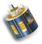
MSG, Meteosat Second Generation, is a serie of geostationary meteorological satellites operated by EUMETSAT.
It consists of a series of four geostationary meteorological satellites, along with ground-based infrastructure, that will operate consecutively until 2020. The MSG satellites carry a pair of instruments — the Spinning Enhanced Visible and InfraRed Imager (SEVIRI), which has the capacity to observe the Earth in 12 spectral channels and provide image data which is core to operational forecasting needs, and the Geostationary Earth Radiation Budget (GERB) instrument supporting climate studies.
It was designed in response to user requirements to serve the needs of Nowcasting applications and numerical weather prediction. In addition the GERB instrument provides important data for climate monitoring and research.
The MSG satellites are spin-stabilised like the previous generation, but with many design improvements. The more frequent and comprehensive data collected by MSG also aids the weather forecaster in the swift recognition and prediction of dangerous weather phenomena such as thunderstorms, fog and explosive development of small but intense depressions which can lead to devastating wind storms.
The MSG satellites are 3.2 m in diameter and 2.4 m high and spins anti-clockwise at 100 RPM at an altitude of 36,000 km.
On January 29, 2004 the first Meteosat Second Generation satellite MSG-1, renamed to Meteosat-8, commenced routine operations.
Meteosat
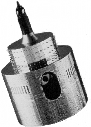
The Meteosat series of satellites are geostationary meteorological satellites operated by the Euopean organisation EUMETSAT.
EUMETSAT
The European Organisation for the Exploitation of Meteorological Satellites (EUMETSAT) is an intergovernmental organisation created through an international convention agreed by a current total of 30 European Member States.
EUMETSAT's primary objective is to establish, maintain and exploit European systems of operational meteorological satellites. EUMETSAT is responsible for the launch and operation of the satellites and for delivering satellite data to end-users as well as contributing to the operational monitoring of climate and the detection of global climate changes.
The activities of EUMETSAT contribute to a global meteorological satellite observing system coordinated with other space-faring nations.
Satellite observations are an essential input to numerical weather prediction systems and also assist the human forecaster in the diagnosis of potentially hazardous weather developments. Of growing importance is the capacity of weather satellites to gather long-term measurements from space in support of climate change studies.
EUMETSAT is not part of the European Union, but became a signatory to the International Charter on Space and Major Disasters in 2012, thus providing for the global charitable use of its space assets.[1]
- public organisation
- Europe
- mission operations
- satellite operator
- meteorology
- Copernicus (EO program)
- Meteosat Third Generation
- Meteosat
- Meteosat Second Generation
- MTG
- MSG
- MTP
- Meteosat Transition Phase
- METOP
- METOP SG
- Sentinel 1
- Sentinel 2 satellite
- Sentinel 2
- Sentinel 3
- Sentinel 4
- sentinel 5P
- sentinel 5
- Sentinel 6
- JasonCS
- Jason 2
- Jason 3
- EPS
- EPS_SG
- NOAA