Displaying items by tag: Eumetsat
Iguassu Software Systems

Iguassu Software Systems (ISS) excels in design and development of technology software applications and in aerospace marketing consultancy for Latin America and central Europe. Its core business is with the European Space Agency (ESA) and other space customers. During the transition period before full ESA membership (PECS 2005-2008), ISS was the most successful Czech space company, having been awarded 6 contracts, 2 of which through participation in international competitive tenders. Since the Czech accession to the ESA convention at the end of 2008, ISS is again in the forefront – the only Czech company to be awarded more than one project (in fact 3) in the ESA Czech industrial incentive scheme in 2009 and the only one to win work in competitive tenders with Astrium D and EOX in 2010.
Copernicus: Sentinel-6 - Michael Freilich Mission - formerly Jason-CS Mission
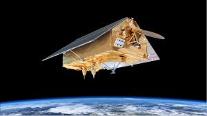
Jason-CS is the second component of the hybrid solution (Jason-3 + Jason-CS) agreed to in 2009. Jason-CS will ensure continuity with Jason-3 to guarantee adequate overlap with Jason-3. At least two satellites with a 7 years lifetime each (5 years + 2 years consumables) are planned to give time before new technologies such as swath interferometry (SWOT mission) can be considered as operational. 1) 2)
The Jason-CS satellite will carry a radar altimeter package to continue the high-precision, low-inclination altimetry missions of Jason-2 and -3. It will complement the high-inclination measurements on Sentinel-3 to obtain high-precision global sea-surface topography for the marine and climate user community.
Copernicus: Sentinel-4 - GEO Component Mission
The Sentinel-4 (S-4) mission within the context of Copernicus represents the geostationary component of European (EC, ESA) operational atmospheric composition monitoring missions.
In December 2007, the GMES Atmospheric Service Implementation Group of the EC (European Commission), issued its preliminary recommendations for the development of the GMES Space Segment operational capabilities in regard of atmospheric missions. In particular, it recommended implementing the Sentinel-4 mission as a UVN (UV/Visible/Near-infrared) sounder to be deployed on the two MTG Sounding (MTG-S) satellites. 1) 2) 3) 4) 5) 6)
|
Copernicus is the new name of the European Commission's Earth Observation Programme, previously known as GMES (Global Monitoring for Environment and Security). The new name was announced on December 11, 2012, by EC (European Commission) Vice-President Antonio Tajani during the Competitiveness Council. In the words of Antonio Tajani: "By changing the name from GMES to Copernicus, we are paying homage to a great European scientist and observer: Nicolaus Copernicus (1473-1543). As he was the catalyst in the 16th century to better understand our world, so the European Earth Observation Programme gives us a thorough understanding of our changing planet, enabling concrete actions to improve the quality of life of the citizens. Copernicus has now reached maturity as a programme and all its services will enter soon into the operational phase. Thanks to greater data availability user take-up will increase, thus contributing to that growth that we so dearly need today." |
Table 1: Copernicus is the new name of the former GMES program 7)
MetOp (Meteorological Operational Satellite Program of Europe)
MetOp-A is Europe's first polar-orbiting (LEO) satellite dedicated to operational meteorology. The MetOp program was originally planned as a much larger satellite concept, called POEM (Polar-Orbit Earth-Observation Mission), a successor mission series to ERS-1/2 on the Columbus Polar Platform (PPF design).
However, this idea was abandoned at the ESA Ministerial Council in Granada, Spain, in 1992. Instead, Envisat and MetOp were born. Full approval of the EPS (EUMETSAT Polar System) program was granted in September 1998. The MetOp program is planned as a series of three satellites to be launched sequentially over an observational period of 14 years, starting in 2006 with MetOp-A (2010, 2014), it represents the space segment of EPS. 1) 2)
EPS (EUMETSAT Polar System)
The EUMETSAT Polar System (EPS) is a European satellite system that offers remote sensing capabilities to both meteorologists and climatologists. It consists of a series of three polar orbiting Metop satellites, to be flown successively for more than 14 years, from 2006, together with the relevant ground facilities.
The satellites form the space segment component of the overall EPS system, which in turn is the European half of the EUMETSAT/NOAA Initial Joint Polar System (IJPS).
Metop-A (launched on 19 October 2006) and Metop-B (launched on 17 September 2012) are in a lower polar orbit, at an altitude of 817 kilometres, to provide more detailed observations of the global atmosphere, oceans and continents. The two satellites will operate in parallel for as long as Metop-A's available capacities bring benefits to users. Metop-C is due to be launched in 2017.
EPS Programme Background
EUMETSAT is responsible for coordinating all elements of the development, launch and operation of EPS satellites. This includes developing and procuring the ground segment; procuring the launcher and launch site, and operating the systems. Under the IJPS and Joint Transition Activities (JTA) agreement, EUMETSAT and NOAA have agreed to provide instruments for each other's satellites; exchange all data in real time, and assist each other with backup services. Other partners are European Space Agency and CNES.
The European and American satellites carry a set of identical sensors:
AVHRR/3 and the ATOVS suite consisting of AMSU-A, HIRS/4 and MHS. NOAA provides most of the joint instruments on board the satellites and EUMETSAT has developed and provides NOAA with the Microwave Humidity Sounder (MHS).
In addition, the Metop satellites carry a set of European sensors, IASI, ASCAT, GOME-2 and GRAS, aimed at improving atmospheric soundings, as well as measuring atmospheric ozone and near-surface wind vectors over the ocean. They also carry the Argos Advanced Data Collection System (A-DCS).
MTG - Meteosat Third Generation
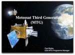
MTG, Meteosat Third Generation, is a serie of geostationary meteorological satellites that will be procured and operated by the organisation EUMETSAT.
Considering the long development cycle for a new observational space system, EUMETSAT has been working on the definition and the planning for a Meteosat Third Generation (MTG) system since the year 2000, as a continuation of the Meteosat (1st generation) and MSG (2nd generation) missions.
The Meteosat Third Generation series will comprise six satellites, with the first spacecraft likely to be ready for launch from 2018. The in orbit configuration will consist of two parallel positioned satellites, the MTG-I imager (a 3-tonne satellite with 16 nominal channels) and the MTG-S sounder. The sounder will be one of the key innovations in the new programme, allowing Meteosat satellites, for the first time, to not just image weather systems but to analyse the atmosphere layer-by-layer and perform far more detailed chemical composition studies.
Unlike the first and second generation Meteosat series, MTG will be based on three axes stabilised platforms, meaning the instruments will be pointed at the Earth for 100% of their in orbit time. Such improvements are necessary to achieve compliance with more demanding user requirements on spatial resolution; repeat cycle and signal to noise ratio, and are a prerequisite to conduct soundings from geostationary orbit.
MTG components providing continuity of MSG services need to be available around 2015, before the end of the nominal lifetime of MSG. MTG preparatory activities started end of 2000 in cooperation with the European Space Agency (ESA), following the decision of the EUMETSAT Council to proceed with a Post-MSG User Consultation Process. The process is aimed at capturing the foreseeable needs of users of EUMETSAT's satellite data in the 2015-2025 timeframe.
EPS-SG (programme)
EPS is a programme of Earth observation for Meteorology and weather forecast. The satellite is called METOP. EPS/METOP is managed by the European organisation EUMETSAT. Placed on a polar orbit, the satellite sends picture of the whole Earth.
EPS-SG is the Second Generation of this programme. (respectively the satellite is METOP-SG)
Activities are on-going (Aug. 2012) for the definition of the follow-on EUMETSAT Polar System, to replace the current satellite system in the 2020 timeframe and contribute to the Joint Polar System to be set up with NOAA. Through consultation with users and application experts, requirements have been defined for a range of candidate missions mainly in support of operational meteorology and climate monitoring. A number of on-board instruments, satellite platforms and ground support infrastructure are under study in coordination with ESA, NOAA, DLR and CNES. The satellites will fly, like Metop, in a sun synchronous, low earth orbit at 817 km altitude and 09:30 local time of the descending node, providing observations over the full globe with revisit times of 12 to 24 hours, depending on instrument. Feasibility studies are on-going with the main objective to define the baseline configuration for subsequent detailed design, development and operation programmes to be proposed and coordinated within the involved organisations. Started in 2005 under the name of Post-EPS, the activities will enter in 2012 the design and development phases under a new programme: EPS Second Generation (EPS-SG).
MSG - Meteosat Second Generation
MSG, Meteosat Second Generation, is a serie of geostationary meteorological satellites operated by EUMETSAT.
It consists of a series of four geostationary meteorological satellites, along with ground-based infrastructure, that will operate consecutively until 2020. The MSG satellites carry a pair of instruments — the Spinning Enhanced Visible and InfraRed Imager (SEVIRI), which has the capacity to observe the Earth in 12 spectral channels and provide image data which is core to operational forecasting needs, and the Geostationary Earth Radiation Budget (GERB) instrument supporting climate studies.
It was designed in response to user requirements to serve the needs of Nowcasting applications and numerical weather prediction. In addition the GERB instrument provides important data for climate monitoring and research.
The MSG satellites are spin-stabilised like the previous generation, but with many design improvements. The more frequent and comprehensive data collected by MSG also aids the weather forecaster in the swift recognition and prediction of dangerous weather phenomena such as thunderstorms, fog and explosive development of small but intense depressions which can lead to devastating wind storms.
The MSG satellites are 3.2 m in diameter and 2.4 m high and spins anti-clockwise at 100 RPM at an altitude of 36,000 km.
On January 29, 2004 the first Meteosat Second Generation satellite MSG-1, renamed to Meteosat-8, commenced routine operations.