Displaying items by tag: imaging system
RocketCam™ Systems
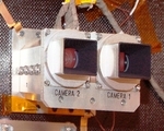
The RocketCam™ systems are onboard imaging systems to provide situational awareness on a rocket, spacecraft or other remote platform.
Ecliptic's integrated RocketCam™ systems help you understand and appreciate what your remote, complex system is doing and experiencing in extreme environments.
You don't need a high-end, expensive, science-quality imaging system. RocketCam™ systems provide engineering and PR-quality situational awareness within a small, rugged, cost-effective package, and are available in analog (Analog Video Systems, AVS), digital (Digital Video System, DVS), and hybrid analog-digital configurations (Integrated Video Assembly, IVA).
Typical system lifetimes for the most demanding applications, space, are hours to months to several years. Selected systems have been ruggedized further to allow for addional tolerance to space-radiation effects, enabling lifetimes of 5 years or more.
company: Ecliptic Enterprises
NGI project

The NGI project (Near Real-Time Geo-annotated Imagery) is an imaging system for near real-time satellite imagery delivery services. The target is to provide rapidly access to GIS-ready imagery within 10 minutes of transmission to ground.
Leading the NGI project, Spacemetric is coordinating an experienced team from Sweden and the UK that will develop and demonstrate the new technologies during the 18-month project. Partners SSC and Metria bring a wealth of experience from ground station operations and satellite image value-adding respectively.
At the same time, Magellium Ltd brings in-depth experience from satellite mapping systems developed by its parent for French Government agencies.
The project is financed within ESA's GSTP programme and is expected to provide service solutions of high interest in a range of application areas including rapid mapping and media. Use of open service standards, such as OGC, is an important element of the project strategy along with the use of Spacemetric's Keystone Image Management System as a COTS to jump-start the technical development work.
Teledyne Technologies

Teledyne Technologies Inc is an industrial conglomerate primarily based in the USA but with global operations. It was founded in 1960, as Teledyne Inc.
Teledyne Technologies currently operates with four major segments: Digital Imaging, Instrumentation, Engineered Systems, and Aerospace and Defense Electronics.
The 'Engineered Systems' segment provides systems engineering and integration, advanced technology application, software development, and manufacturing solutions to space, military, environmental, energy, chemical, biological and nuclear systems, and missile defense requirements. It also designs and manufactures hydrogen gas generators, thermoelectric and fuel-based power sources, and small turbine engines.
The 'Aerospace and Defense Electronics' segment provides complex electronic components and subsystems for communication products, including defense electronics, data acquisition and communications equipment for air transport and business aircraft, and components and subsystems for wireless and satellite communications, as well as general aviation batteries.
Skybox Imaging

Skybox Imaging is developing a high performance constellation of imaging micro-satellites to deliver high resolution imagery of any spot on Earth multiple times per day. Skybox sells timely satellite imagery and derived information products to commercial customers and governments worldwide.
The Skybox team's mission is to expand significantly the use of satellite imagery for commercial customers and governments alike.
Nov 2012: as we approach the launch date of our first satellite, SkySat-1, our team is focused on completing the construction of the satellite and ground infrastructure, as well as building strong relationships with our partners and customers. SkySat-1 is a commercial Earth observation satellite, licensed to collect high resolution panchromatic and multispectral images of the Earth. The satellite will operate in a polar inclined, circular orbit at approximately 450 km above the earth.
Spatial Energy

Spatial Energy is a provider of digital imagery and services within the energy industry.
Solely dedicated to meeting the needs of energy companies operating worldwide, Spatial Energy acquires, processes, and manages an extensive collection of high resolution satellite and aerial imagery, topographic maps, and digital elevation models (DEMs). Imagery is available on demand from an extensive data archives, by tasking satellites and aerial providers, and by speculative collection. Spatial Energy has established preferred relationships with the leading data providers and can thus select the best source(s) to meet a client particular application. In addition, programs such as the Energy Partner Program (EPP), BasinWatch and Spatial on Demand provide simplified, cost effective access to imagery. The company goal is to reduce the cost, time and effort required to acquire imagery for all client needs.
Ecliptic Enterprises
Ecliptic Enterprises is an American company that creates on-board imaging systems for use with rockets, spacecraft, and other remote platforms. It is based in Pasadena, Calif., USA.
Ecliptic Enterprises also provides cost-effective space-access solutions for small space payloads.
The activities of Ecliptic Enterprises encompass:
- imaging and sensor technology for spacecraft,
- small secondary, payload technologies,
- space transportation technologies.
Rochester Institute of Technology (RIT)

Rochester Institute of Technology (RIT) is a private university located within the town of Henrietta in the Rochester, New York metropolitan area.
RIT is composed of nine academic colleges. It is widely known for its fine arts, computing, engineering, and imaging science programs.
RIT has collaborated with many industry players in the field of research as well, including IBM, Xerox, NASA, and the Defense Advanced Research Projects Agency (DARPA).
Selex Galileo

Electronic, mechanical and optical equipment for space and defense; space attitude sensors and optical payload.
SELEX Galileo is a major defence electronics company that specialises in surveillance, protection, tracking, targeting, navigation and control, and imaging systems. It is owned by the Italian company Finmeccanica.
SELEX was created by the Eurosystems transaction between Finmeccanica and BAE Systems which saw the merger of their avionics businesses. Part of BAE Systems Avionics became SELEX Sensors and Airborne Systems Ltd (SELEX S&AS), while part remained with BAE Systems, becoming part of BAE Systems North America Group.
From January 2008, SELEX S&AS and Galileo Avionica began to operate under a common brand name, SELEX Galileo. In January 2010, the operating companies’ legal names were aligned to the brand, becoming SELEX Galileo Ltd and SELEX Galileo S.p.A. respectively. SELEX Sensors and Airborne Systems (US) Inc became SELEX Galileo Inc.