Displaying items by tag: laser
Monday, 15 April 2013 15:28
Geoscience Laser Altimeter System (GLAS)
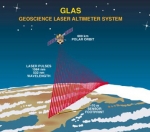
The Geoscience Laser Altimeter System (GLAS) is an instrument onboard the ICESat satellite.
This instrument will determine the distance from the satellite to the Earth's surface and to intervening clouds and aerosols. It will do this by precisely measuring the time it takes for a short pulse of laser light to travel to the reflecting object and return to the satellite. Although surveyors routinely use laser methods, the challenge for ICESat is to perform the measurement 40 times a second from a platform moving 26,000 km (16,000 mi) per hour. In addition, ICESat will be 600 km above the Earth and the precise locations of the satellite in space and the laser beam on the surface below must be determined at the same time.
Published in
Projects
Tagged under