
Copernical Team
Russian, European astronauts make rare joint spacewalk at ISS
 A Russian cosmonaut and European Space Agency engineer made a several-hour spacewalk at the International Space Station on Thursday to work on a robotic laboratory arm.
The pair began the spacewalk around 10 a.m. EDT and it was scheduled to last about six hours.
The objective of the mission is to continue outfitting the European robotic arm on the ISS Nauka laboratory.
Com
A Russian cosmonaut and European Space Agency engineer made a several-hour spacewalk at the International Space Station on Thursday to work on a robotic laboratory arm.
The pair began the spacewalk around 10 a.m. EDT and it was scheduled to last about six hours.
The objective of the mission is to continue outfitting the European robotic arm on the ISS Nauka laboratory.
Com Northrop Grumman and NASA test SLS booster
 Northrop Grumman and NASA have conducted a full-scale static fire of NASA's Space Launch System (SLS) rocket motor, known as Flight Support Booster-2. The five-segment solid rocket booster is the world's largest solid rocket motor and will provide more than 75 percent of the SLS rocket's initial thrust during launch.
Over 300 measurement channels assessed the 154-foot-long solid rocket boo
Northrop Grumman and NASA have conducted a full-scale static fire of NASA's Space Launch System (SLS) rocket motor, known as Flight Support Booster-2. The five-segment solid rocket booster is the world's largest solid rocket motor and will provide more than 75 percent of the SLS rocket's initial thrust during launch.
Over 300 measurement channels assessed the 154-foot-long solid rocket boo SpaceX delays 32nd launch of year, putting off attempt at record for one more day
 SpaceX will delay Thursday's Starlink launch, an attempt by the company to beat its record of 31 launches in 2021 with a 32nd launch this year, until Friday because of fog.
The countdown to launch was aborted seconds ahead of the Falcon 9 rocket's planned launch of 46 Starlink satellites to low-Earth orbit from the from the Vandenberg Space Force Base in California.
The lift off
SpaceX will delay Thursday's Starlink launch, an attempt by the company to beat its record of 31 launches in 2021 with a 32nd launch this year, until Friday because of fog.
The countdown to launch was aborted seconds ahead of the Falcon 9 rocket's planned launch of 46 Starlink satellites to low-Earth orbit from the from the Vandenberg Space Force Base in California.
The lift off Georgia spaceport land deal is off, site owner says

You can see where the Webb Telescope took a direct hit from a micrometeorite on one of its mirrors
. Credit: NASA/ESA/CSA")
The world is still reeling from the release of the James Webb Space Telescope's (JWST) first images. These provided a comprehensive overview of the kind of science operations that Webb will conduct over its 20-year mission. They included the most sensitive and detailed look at some iconic astronomical objects, spectra from an exoplanet atmosphere, and a deep field view of some of the most distant galaxies in the universe. Since their release, we've also been treated to glimpses of objects in the solar system captured by Webb's infrared instruments.
Meanwhile, the JWST collaboration released a full report titled titled "Characterization of JWST science performance from commissioning," in which they examined everything Webb has accomplished so far and what they anticipate throughout the mission.
You can buy SpaceX toys and collectibles starting next year

SpaceX is venturing into the toy business.
Mattel announced Wednesday it is partnering with SpaceX on a new line of toys and collectibles inspired by the aerospace company co-founded by Tesla CEO Elon Musk.
The toys will be available in 2023 through Mattel's Matchbox brand as well as Mattel Creations, the company's direct-to-consumer platform.
"We take pride in our ability to create products and experiences that honor cultural moments and inspire humankind," said Nick Karamanos, Mattel's senior vice president of entertainment partnerships, in a statement.
Mattel has created multiple toys through its various brands including Hot Wheels and Barbie to promote space exploration. For example, the toy maker currently offers an astronaut version of its Barbie doll and several Hot Wheels vehicles based on Mars rovers.
In April, Mattel announced it was sending two Barbie dolls to space in partnership with the International Space Station to encourage girls to consider careers in science, technology, engineering and math.
Explore further
(c)2022 USA Today
Distributed by Tribune Content Agency, LLC.
New method to map the surface of the moon increases accuracy to unprecedented levels

Italian becomes first European woman on spacewalk outside ISS

Italian Samantha Cristoforetti became the first European woman astronaut to embark on a spacewalk outside the International Space Station on Thursday, NASA footage showed.
Cristoforetti was joined by Russian cosmonaut Oleg Artemyev on the spacewalk which began just before 1500 GMT, with the pair expected to spend around six and half hours more than 400 kilometres (248 miles) above Earth.
Among their tasks is work on a Europe-made robotic arm which just a week ago became embroiled in tensions between Russia and the West over Moscow's war in Ukraine.
Early last week the head of Russian space agency Roscosmos Dmitry Rogozin, furious at the European Space Agency's decision to cut ties with Moscow on a Mars rover mission, told cosmonauts on the ISS to stop using the European Robotic Arm.
But President Vladimir Putin dismissed Rogozin as Roscosmos chief on Friday, and hours later Washington and Moscow said they would renew flights together to the ISS.
Solar storm to hit Earth's magnetic field on July 21

Something is happening to the sun. One of the regions of the solar atmosphere currently exhibiting sunspots caught the attention of observatories on July 11, when there was a sudden increase in ultraviolet and X-ray brightness. The next ones to notice were the amateur radio communities on either side of the Pacific Ocean, when their communications were briefly interrupted.
A solar flare—the emission of electromagnetic radiation and energetic particles located in a small region of the solar atmosphere—had just occurred. It is a region where the magnetic field is particularly strong and complex.
SPECTACULAR FILAMENT ERUPTION: A filament stretching halfway across the solar disk became unstable and erupted away from the Sun. Couple things to note: (1) A section of it twists (magnetic energy being released).
EarthCARE takes a big stretch
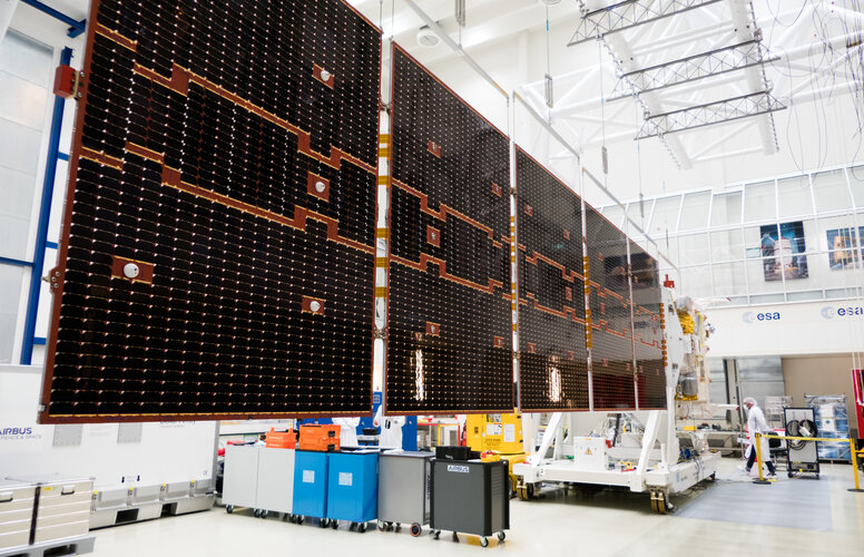
ESA’s upcoming EarthCARE satellite mission has just taken a big stretch. Engineers have gently unfolded this new satellite’s huge five-panel solar wing to test that it will deploy correctly once it is in space. The solar wing is a critical part of the satellite, providing the energy for EarthCARE to do its job: to quantify the role that clouds and aerosols play in heating and cooling Earth’s atmosphere.